KMCN

MIDDLE GEORGIA RGNL
MACON
GA
Time Zone: Eastern
Lat: N 3241.6
Long: W 08339.0
Elev: 354
Var: +06
Longest Runway: 6500
Dept. ATIS: 120.77
Arr. ATIS: 120.77
AWOS: 120.77
Ground: 121.65
Tower: 128.2

FBO & Flight Services info for KMCN

FBOs: Update your Fuel Prices

HIGHNOTE AVIATIONPh: 478-310-4689
-
Freq: 122.95
Service
Jet
100LL
SAF
MoGas
Fuel Avail: PRIST PREMIXED.
Full6.026.18    Last Update: 04/05/2024 09:35

Self  5.68    
 Address: 2178 FLIGHTLINE AVE   MACON, GA 31297
ASOSPh: 478-784-8825
-
Freq: 120.77  
If you are an FBO, call 1-203-262-1700 to update your info or email: FltPlan.Advertising@garmin.com
Advertise your FBO on FltPlan.com

Runway & Approach Info for KMCN
Rwy
Length
Land Dist**
Approach*
  Rwy
Length
Land Dist**
Approach*
05
6500x150  6500'          
ILS
 109.50 - 053°  
  
23
  6500x150  6500'          
 
14
5000x150  5000'          
 
  
32
  5000x150  5000'          
 
 * only ILS, LOC, LDA, and SDF approaches to a specific runway are shown
** For any Declared Landing Distance Available, please see A/FD or Approach plates
Runway Weight Capability (lbs.) Help
Runway IDSingle WheelDouble WheelDouble Tandem WheelDual Double Wheel
05/2380,000128,000237,000N/A
14/3244,00065,000110,000N/A
These numbers are Advisory and are not limits.   The Airport Manager should have more accurate Weight Limits
Approach Charts
Approaches    
Current Weather/Notams
Customs Information Send updates to Support@FltPlan.com
Customs Not Available
Database effective 04/18/2024
Airport Diagram of KMCN
Airport Diagram might not be current.

Facility Name: MIDDLE GEORGIA RGNL
City Name: MACON
County: BIBB
State abbrev: GA
State Name: GEORGIA
   
Ownership: PUBLICLY OWNED
Use: OPEN TO THE PUBLIC
Owner's Name: MACON-BIBB COUNTY
Address: CITY HALL
 MACON, GA 31202
Owner's Phone: 478-788-3760
  
Manager's Name: DOUGLAS FAOUR
Address: 1000 TERMINAL DR
 MACON, GA 31297
Phone: 478-219-1145
   
FAA Region: SOUTHERN
FAA Field Office: ATL


Sunrise / Sunset times for MIDDLE GEORGIA RGNL

DateSunriseSunset
04/17/24 Wednesday7:0220:07
04/18/24 Thursday7:0120:07
04/19/24 Friday7:0020:08
04/20/24 Saturday6:5820:09
04/21/24 Sunday6:5720:10
04/22/24 Monday6:5620:10
04/23/24 Tuesday6:5520:11
04/24/24 Wednesday6:5420:12
04/25/24 Thursday6:5320:12
04/26/24 Friday6:5220:13
04/27/24 Saturday6:5120:14
04/28/24 Sunday6:5020:15
04/29/24 Monday6:4920:15
04/30/24 Tuesday6:4820:16

Airport Facilities

Airport Attendance Schedule7 Days A Week 0500-2000; FOR SVC AFT HRS HIGHNOTE AVIATION - 478-957-9791.
Airport Status OPERATIONAL (This Status can change at any time - please check NOTAMS)
Airport Lighting ScheduleACTVT MALSR RWY 05; REIL RWY 23 & 32; HIRL RWY 05/23; MIRL RWY 14/32 & TWY LGTS - CTAF.
Airport Storage AvailableTie Downs, Hanger
Extra Services AvailableAir Freight, Air Ambulance, Charter, Flight Instruction, Aircraft Rental, Aircraft Sales
Wind IndicatorYES - (lighted)
Control TowerYES
CTAF Frequency128.200
Unicom Frequency122.950
Rotating Beacon ColorWG
Segmented CircleYES
Landing FeeNO

Airport Inspection Data

Airport InspectedFEDERAL - performed by FAA AIRPORTS FIELD PERSONNEL
Inspection Date02/01/2024

Airport Services

Type of Fuel AvailableGrade 100LL, JET A (freeze point -40C)
Airframe Repair ServiceMAJOR
Power Plant Repair ServiceMAJOR

Geographic Data

LatitudeN3241.6
LongitudeW08339.0 (ESTIMATED)
Arpt Elevation354ft (SURVEYED)
Magnetic Variation06W
9 miles Sof MACON
Traffic Pattern Altitude
Sectional ChartATLANTA

Aircraft Data

Operations (Reported)YearlyAvg. Daily
General Aviation Transient 1289435
General Aviation Local 956526
Air Taxi 18515
Commerical 2931
Commuter 00
Military 5141
Aircraft based on Field
General Aviation Singles 36
General Aviation Multi 26
Jet Aircraft 13
General Aviation Helicopters 3
Military Aircraft 0
Gliders 0
Ultralights 0

FAA Services

FSS on field NO
FSS tie-in MACON
FSS Phone 1-800-WX-BRIEF
Who issues Notams MCN
Notam D service at airport YES
ARTCC Name ATLANTA

Federal Status

Airport CertificationAIRPORT RECEIVING SCHEDULED AIR CARRIER SERVICE FROM CARRIERS CERTIFICATED BY THE CIVIL AERONAUTICS BOARD
Aircraft Rescue & Firefighting IndexAIRPORT HAS A CERTIFICATE UNDER CFR PART 139
Airport of EntryNo
Custom Landing RightsNo
Joint Civil/MilitaryNo
Military Landing rightsYES

Federal Agreements

NATIONAL PLAN OF INTEGRATED AIRPORT SYSTEMS (NPIAS)
GRANT AGREEMENTS UNDER FAAP/ADAP/AIP
SURPLUS PROPERTY AGREEMENT UNDER PUBLIC LAW 289
ASSURANCES PURSUANT TO TITLE VI, CIVIL RIGHTS ACT OF 1964

Remarks

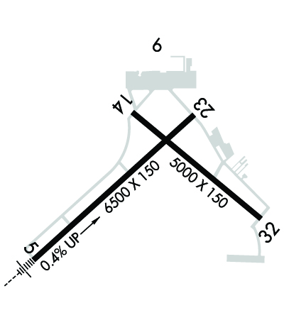
ROBINS AFB CLASS D AIRSPACE .4 MI SE OF DEP END RY 14. VFR ACFT DEP RY 14 BTN 2000-0800 ARE ADVISED TO CTC ROBINS ATCT 133.22/320.1 PRIOR TO DEP.
DEER ON & INVOF ARPT.
PAEW ADJ TO THE MOVEMENT AREAS FROM MARCH 1 TO NOV 1 FOR GRASS CUTTING.
FOR CD IF UNA TO CTC ON FSS FREQ, CTC ATLANTA APCH AT 678-364-6132, WHEN ATCT CLSD CTC ATLANTA ARTCC AT 770-210-7692.
NO ACFT WITH WINGSPAN GTR THAN 118 FT MAY TAXI ON TWY C BTN RWY 23 AND RWY 32.
Airport Communications & Frequencies:
ATIS Frequencies:   Hours(local) of Operation: CONTINUOUS
120.775
MACON Tower Frequencies:   Hours(local) of operation: 0800-2000   
128.2
257.8
MACON Ground Frequencies:
121.65
Emergency Frequencies:
121.5
CTAF Frequency:
128.200
Unicom Frequency:
122.950
Remarks
  • ATLANTA LARGE TRACON PROVIDES APCH/DEP SVC 0615-2300 ON FREQ 124.2/279.6; ATLANTA ARTCC PROVIDES APCH/DEP SVC 2300-0615 ON FREQS 134.5/360.75 (MACON RCAG).
  • ATLANTA Primary Approach Frequencies:  
    124.2
    279.6
    388.2 7000 FT & ABV
    ATLANTA Primary Departure Frequencies:  
    124.2
    279.6
    388.2 7000 FT & ABV
    Runway Identifications
    Runway Identification: 05/23
    Length: 6500 ft
    Width: 150 ft
    Surface: ASPHALT-GOOD CONDITION
    Edge lights: High Intensity

    Treatment: GROOVED
    Weight: PCN 54 /F/B/W/U

     Runway: 05   Runway: 23
    Mag heading: 54°Mag heading: 234°
    Rwy Slope: .36% UpRwy Slope: -.36% Down
    Approach: ILSApproach:
    Pattern: Left TrafficPattern: Right Traffic
    Markings: PRECISION INSTRUMENTMarkings: NONPRECISION INSTRUMENT
    Marking Condition: GOODMarking Condition: GOOD
    Arresting Dev: Arresting Dev:
    Lat & Long: N3241.2  W08339.6Lat. & Long.: N3241.9  W08338.7
    Elev: 331.0 ft. MSLElev: 354.2 ft. MSL
    TCH: TCH: 67 ft. AGL
    Visual Glide Path: Visual Glide Path: 3.00 degrees
    Displaced Threshold: NoDisplaced Threshold: No
    Touchdown Zone: YESTouchdown Zone: YES
    Touchdown Elev.: 344.3 feetTouchdown Elev.: 354.2 feet
    Visual Glide Slope: Visual Glide Slope: 4-Light PAPI on LEFT side of Runway
    RVR Equipment: TOUCHDOWNRVR Equipment: ROLLOUT
    RVV Equipment: NORVV Equipment: NO
    Approach Lights: MALSR - 1,400 foot medium intensity approach lighting system with runway alignment indicator lightsApproach Lights:
    REIL: NOREIL: YES
    Centerline Lights: NOCenterline Lights: NO
    Touchdown lights: NOTouchdown lights: NO
    Runway Category: Precision Instrument RunwayRunway Category: Runway with a Non-precision Approach having visibility minimums greater than 3/4 mile
    Declared Distances: TORA:6501' TODA:6501' ASDA:6221' LDA:6221'Declared Distances: TORA:6501' TODA:6501' ASDA:6426' LDA:6426'
    Obstructions: TREESObstructions: TREES
    Marked: NOT Marked/LightedMarked: NOT Marked/Lighted
    Clearance slope: 50:1Clearance slope: 20:1
    Obstruction height: 27 feet AGLObstruction height: 47 feet AGL
    Dist. from runway: 1540 feetDist. from runway: 1140 feet
    Centerline offset: 450 right of centerlineCenterline offset: 350 feet right of centerline
    Comments: Comments:
    Runway Identification: 14/32
    Length: 5000 ft
    Width: 150 ft
    Surface: ASPHALT
    Edge lights: Medium Intensity

    Treatment: GROOVED
    Weight: PCN 46 /F/B/W/U

     Runway: 14   Runway: 32
    Mag heading: 136°Mag heading: 316°
    Rwy Slope: -.17% DownRwy Slope: .17% Up
    Approach: Approach:
    Pattern: Right TrafficPattern: Left Traffic
    Markings: NONPRECISION INSTRUMENTMarkings: NONPRECISION INSTRUMENT
    Marking Condition: GOODMarking Condition: GOOD
    Arresting Dev: Arresting Dev:
    Lat & Long: N3241.9  W08339.0Lat. & Long.: N3241.4  W08338.3
    Elev: 353.7 ft. MSLElev: 345.3 ft. MSL
    TCH: 46 ft. AGLTCH: 46 ft. AGL
    Visual Glide Path: 3.00 degreesVisual Glide Path: 3.00 degrees
    Displaced Threshold: NoDisplaced Threshold: No
    Touchdown Zone: YESTouchdown Zone: YES
    Touchdown Elev.: 354.0 feetTouchdown Elev.: 351.4 feet
    Visual Glide Slope: 4-Light PAPI on LEFT side of RunwayVisual Glide Slope: 4-Light PAPI on LEFT side of Runway
    RVR Equipment: RVR Equipment:
    RVV Equipment: NORVV Equipment: NO
    Approach Lights: Approach Lights:
    REIL: NOREIL: YES
    Centerline Lights: NOCenterline Lights: NO
    Touchdown lights: NOTouchdown lights: NO
    Runway Category: Runway with a Non-precision Approach having visibility minimums greater than 3/4 mileRunway Category: Runway with a Non-precision Approach having visibility minimums greater than 3/4 mile
    Declared Distances: TORA:5000' TODA:5000' ASDA:5000' LDA:5000'Declared Distances: TORA:5000' TODA:5000' ASDA:5000' LDA:5000'
    Obstructions: TREESObstructions: RR
    Marked: NOT Marked/LightedMarked: NOT Marked/Lighted
    Clearance slope: 20:1Clearance slope: 10:1
    Obstruction height: 43 feet AGLObstruction height: 32 feet AGL
    Dist. from runway: 1060 feetDist. from runway: 525 feet
    Centerline offset: 50 left of centerlineCenterline offset: 300 feet right of centerline
    Comments: Comments:
    C:58/P: