Current Weather/Notams (Metars, TAFs, Notams, NWS Forecast, PIREPS, and nearby weather)
Customs Information Send updates to Support@FltPlan.com
Customs Not Available
Database effective 05/16/2024
Airport Diagram might not be current.
|
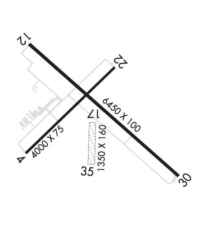
| Facility Name: | MC COOK BEN NELSON RGNL |
| City Name: | MC COOK |
| County: | RED WILLOW |
| State abbrev: | NE |
| State Name: | NEBRASKA |
| | |
| Ownership: | PUBLICLY OWNED |
| Use: | OPEN TO THE PUBLIC |
| Owner's Name: | CITY OF MC COOK |
| Address: | BOX 1059 |
| | MC COOK, NE 69001 |
| Owner's Phone: | 308-345-2022 |
| | |
| Manager's Name: | MR. NATE SCHNEIDER; CITY MANAGER. |
| Address: | BOX 1059 |
| | MC COOK, NE 69001 |
| Phone: | 308-345-2022 |
| | |
| FAA Region: | CENTRAL |
| FAA Field Office: | NONE |
Runway Identifications
Runway Identification: 04/22Length: 4000 ft
Width: 75 ft
Surface: CONCRETE-GOOD CONDITION
Edge lights: Medium IntensityTreatment: NONE
Weight: PCN 34 /R/C/W/T
| | Runway: 04 | | Runway: 22 |
| Mag heading: | 38° | Mag heading: | 218° |
| Rwy Slope: | -.18% Down | Rwy Slope: | .18% Up |
| Approach: | | Approach: | |
| Pattern: | Right Traffic | Pattern: | Left Traffic |
| Markings: | NONPRECISION INSTRUMENT | Markings: | NONPRECISION INSTRUMENT |
| Marking Condition: | FAIR | Marking Condition: | FAIR |
| Arresting Dev: | | Arresting Dev: | |
| Lat & Long: | N4012.2 W10036.0 | Lat. & Long.: | N4012.6 W10035.4 |
| Elev: | 2562.6 ft. MSL | Elev: | 2555.6 ft. MSL |
| TCH: | 26 ft. AGL | TCH: | 26 ft. AGL |
| Visual Glide Path: | 3.00 degrees | Visual Glide Path: | 3.00 degrees |
| Displaced Threshold: | No | Displaced Threshold: | No |
| Touchdown Zone: | YES | Touchdown Zone: | YES |
| Touchdown Elev.: | 2564.9 feet | Touchdown Elev.: | 2564.9 feet |
| Visual Glide Slope: | 2-Box VASI on LEFT side of Runway | Visual Glide Slope: | 2-Box VASI on LEFT side of Runway |
| RVR Equipment: | | RVR Equipment: | |
| RVV Equipment: | NO | RVV Equipment: | NO |
| Approach Lights: | | Approach Lights: | |
| REIL: | NO | REIL: | NO |
| Centerline Lights: | NO | Centerline Lights: | NO |
| Touchdown lights: | NO | Touchdown lights: | NO |
| Runway Category: | Runway with a Visual Approach | Runway Category: | Runway with a Non-precision Approach having visibility minimums greater than 3/4 mile |
| Declared Distances: | TORA:4000' TODA:4000' ASDA:4000' LDA:4000' | Declared Distances: | TORA:4000' TODA:4000' ASDA:4000' LDA:4000' |
| Obstructions: | POLE | Obstructions: | |
| Marked: | NOT Marked/Lighted | Marked: | |
| Clearance slope: | 26:1 | Clearance slope: | 20:1 |
| Obstruction height: | 25 feet AGL | Obstruction height: | |
| Dist. from runway: | 850 feet | Dist. from runway: | |
| Centerline offset: | 100 left of centerline | Centerline offset: | |
| Comments: | | Comments: | |
Runway Identification: 12/30Length: 6450 ft
Width: 100 ft
Surface: CONCRETE-GOOD CONDITION
Edge lights: Medium IntensityTreatment: NONE
| | Runway: 12 | | Runway: 30 |
| Mag heading: | 123° | Mag heading: | 303° |
| Rwy Slope: | -.39% Down | Rwy Slope: | .39% Up |
| Approach: | ILS/DME | Approach: | |
| Pattern: | Left Traffic | Pattern: | Right Traffic |
| Markings: | PRECISION INSTRUMENT | Markings: | NONPRECISION INSTRUMENT |
| Marking Condition: | FAIR | Marking Condition: | FAIR |
| Arresting Dev: | | Arresting Dev: | |
| Lat & Long: | N4012.7 W10036.0 | Lat. & Long.: | N4012.0 W10034.9 |
| Elev: | 2582.9 ft. MSL | Elev: | 2557.7 ft. MSL |
| TCH: | 38 ft. AGL | TCH: | 44 ft. AGL |
| Visual Glide Path: | 3.00 degrees | Visual Glide Path: | 3.00 degrees |
| Displaced Threshold: | No | Displaced Threshold: | 750 feet |
| Touchdown Zone: | YES | Touchdown Zone: | YES |
| Touchdown Elev.: | 2582.9 feet | Touchdown Elev.: | 2557.7 feet |
| Visual Glide Slope: | 4-Light PAPI on LEFT side of Runway; UNUSBL BYD 5 DEGS RIGHT OF CNTRLN AND 8 DEGS LEFT OF CNTRLN. | Visual Glide Slope: | 4-BOX VASI ON LEFT SIDE OF RUNWAY |
| RVR Equipment: | | RVR Equipment: | |
| RVV Equipment: | NO | RVV Equipment: | NO |
| Approach Lights: | MALSR - 1,400 foot medium intensity approach lighting system with runway alignment indicator lights | Approach Lights: | |
| REIL: | NO | REIL: | YES |
| Centerline Lights: | NO | Centerline Lights: | NO |
| Touchdown lights: | NO | Touchdown lights: | NO |
| Runway Category: | Precision Instrument Runway | Runway Category: | Runway with a Non-precision Approach having visibility minimums greater than 3/4 mile |
| Declared Distances: | TORA:6448' TODA:6448' ASDA:5698' LDA:5698' | Declared Distances: | TORA:6448' TODA:6448' ASDA:6448' LDA:5698' |
| Obstructions: | TREE | Obstructions: | |
| Marked: | NOT Marked/Lighted | Marked: | |
| Clearance slope: | 34:1 | Clearance slope: | 50:1 |
| Obstruction height: | 30 feet AGL | Obstruction height: | |
| Dist. from runway: | 1225 feet | Dist. from runway: | |
| Centerline offset: | 475 left of centerline | Centerline offset: | |
| Comments: | | Comments: | |
Runway Identification: 17/35Length: 1330 ft
Width: 160 ft
Surface: GRASS-FAIR CONDITION
Edge lights: Treatment: NONE
| | Runway: 17 | | Runway: 35 |
| Mag heading: | 173° | Mag heading: | 353° |
| Rwy Slope: | .25% Up | Rwy Slope: | -.25% Down |
| Approach: | | Approach: | |
| Pattern: | Left Traffic | Pattern: | Right Traffic |
| Markings: | | Markings: | |
| Marking Condition: | 17/35 THR BDRY MKRS. | Marking Condition: | |
| Arresting Dev: | | Arresting Dev: | |
| Lat & Long: | N4012.3 W10035.5 | Lat. & Long.: | N4012.1 W10035.5 |
| Elev: | 2558.0 ft. MSL | Elev: | 2561.3 ft. MSL |
| TCH: | | TCH: | |
| Visual Glide Path: | | Visual Glide Path: | |
| Displaced Threshold: | No | Displaced Threshold: | No |
| Touchdown Zone: | YES | Touchdown Zone: | YES |
| Touchdown Elev.: | 2562.3 feet | Touchdown Elev.: | 2562.3 feet |
| Visual Glide Slope: | | Visual Glide Slope: | |
| RVR Equipment: | | RVR Equipment: | |
| RVV Equipment: | NO | RVV Equipment: | NO |
| Approach Lights: | | Approach Lights: | |
| REIL: | NO | REIL: | NO |
| Centerline Lights: | NO | Centerline Lights: | NO |
| Touchdown lights: | NO | Touchdown lights: | NO |
| Runway Category: | Runway with a Visual Approach | Runway Category: | Runway with a Visual Approach |
| Declared Distances: | | Declared Distances: | |

