Click here for more info on on SMS!

KMCI

KANSAS CITY INTL
KANSAS CITY
MO
Time Zone: Central
Lat: N 3917.9
Long: W 09442.8
Elev: 1027
Var: -02
Longest Runway: 10801
Clr Del: 135.7
Dept. ATIS: 128.37
Arr. ATIS: 128.37
Ground: 121.65/121.8
Tower: 125.75/128.2

FBO & Flight Services info for KMCI

FBOs: Update your Fuel Prices

SIGNATUREPh: 816-243-6440 Fax: 816-243-5674 Freq: 128.85
Service
Jet
100LL
SAF
MoGas
Fuel Avail: PRIST +$0.02/gal.
Full9.098.04    Last Update: 04/24/2024 09:41

Self        
 Address: 880 MEXICO CITY AVE,   KANSAS CITY, MO 64153-1132
ASOSPh: 816-243-6415
-
-
 
ATISPh: 816-243-2725
-
Freq: 128.35  
NOISE RESTRICTPh: 816-243-5248
-
-
 
If you are an FBO, call 1-203-262-1700 to update your info or email: FltPlan.Advertising@garmin.com
Advertise your FBO on FltPlan.com
FBOs at nearby airports who want your business:
KIXD


  click here  
Advanced Jet Center is Kansas City's Premier FBO 95 Full Concierge Service No Ramp Fees 95 Daily Fuel Specials 95 QuickTurn Central 95 X/C Fuel Specials 95 EASYMONEY Pilot Rewards 95 Kansas City Famous BBQ, Beer and Coffee Now Available!
Ph: 913-768-1500 WebsiteE-MailFax: 913-768-1528 Freq: 122.95

Runway & Approach Info for KMCI
Rwy
Length
Land Dist**
Approach*
  Rwy
Length
Land Dist**
Approach*
01L
10801x150  10801'          
ILS/DME
 110.50 - 010°  
  
19R
  10801x150  10801'          
ILS/DME
 109.10 - 190°  
01R
9500x150  9500'          
ILS/DME
 110.75 - 010°  
  
19L
  9500x150  9500'          
ILS/DME
 109.55 - 190°  
09
9501x150  9501'          
ILS/DME
 109.70 - 094°  
  
27
  9501x150  9501'          
ILS/DME
 109.70 - 274°  
 * only ILS, LOC, LDA, and SDF approaches to a specific runway are shown
** For any Declared Landing Distance Available, please see A/FD or Approach plates
Runway Weight Capability (lbs.) Help
Runway IDSingle WheelDouble WheelDouble Tandem WheelDual Double Wheel
01L/19R120,000250,000524,000450,000
01R/19L75,000204,000400,000450,000
09/27120,000250,000465,000260,000
These numbers are Advisory and are not limits.   The Airport Manager should have more accurate Weight Limits
Approach Charts
Approaches    
Current Weather/Notams
Customs Information Send updates to Support@FltPlan.com
Phone 816-584-1994
Fax 816-584-8431

Comments 2 hr advance notice required. Business hrs 0800-1630 Monday-Friday. *Maximum passengers per flight: 30 *M-F Call prior to 1630 on preceeding weekday *WKND Call prior to 1630 on preceeding Friday. kansascitygeneralaviation@cbp.dhs.gov
Database effective 05/16/2024
Airport Diagram of KMCI
Airport Diagram might not be current.

Facility Name: KANSAS CITY INTL
City Name: KANSAS CITY
County: PLATTE
State abbrev: MO
State Name: MISSOURI
   
Ownership: PUBLICLY OWNED
Use: OPEN TO THE PUBLIC
Owner's Name: CITY OF KANSAS CITY
Address: 601 BRASILIA; PO BOX 20047
 KANSAS CITY, MO 64141
Owner's Phone: 816-243-3100
  
Manager's Name: MR. LUKE MAWHIRTER
Address: P.O. BOX 20047
 KANSAS CITY, MO 64195
Phone: 816-243-5248
   
FAA Region: CENTRAL
FAA Field Office: NONE
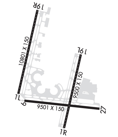

Sunrise / Sunset times for KANSAS CITY INTL

DateSunriseSunset
04/23/24 Tuesday6:3020:05
04/24/24 Wednesday6:2820:06
04/25/24 Thursday6:2720:07
04/26/24 Friday6:2620:08
04/27/24 Saturday6:2420:09
04/28/24 Sunday6:2320:10
04/29/24 Monday6:2220:11
04/30/24 Tuesday6:2120:12
05/01/24 Wednesday6:1920:13
05/02/24 Thursday6:1820:14
05/03/24 Friday6:1720:15
05/04/24 Saturday6:1620:16
05/05/24 Sunday6:1520:17
05/06/24 Monday6:1420:18

Airport Facilities

Airport Attendance ScheduleCONTINUOUS
Airport Status OPERATIONAL (This Status can change at any time - please check NOTAMS)
Airport Lighting Schedule
Airport Storage AvailableTie Downs
Extra Services AvailableCargo Handling
Wind IndicatorYES - (lighted)
Control TowerYES
CTAF Frequency
Unicom Frequency122.950
Rotating Beacon ColorWG
Segmented CircleNO
Landing FeeNO

Airport Inspection Data

Airport InspectedFEDERAL - performed by FAA AIRPORTS FIELD PERSONNEL
Inspection Date08/21/2023

Airport Services

Type of Fuel AvailableGrade 100LL, JET A (freeze point -40C)
Airframe Repair ServiceNONE
Power Plant Repair ServiceNONE

Geographic Data

LatitudeN3917.9
LongitudeW09442.8 (ESTIMATED)
Arpt Elevation1026ft (SURVEYED)
Magnetic Variation02E
15 miles NWof KANSAS CITY
Traffic Pattern Altitude
Sectional ChartKANSAS CITY

Aircraft Data

Operations (Reported)YearlyAvg. Daily
General Aviation Transient 34369
General Aviation Local 2611
Air Taxi 352410
Commerical 98566270
Commuter 00
Military 12483
Aircraft based on Field
General Aviation Singles 0
General Aviation Multi 0
Jet Aircraft 2
General Aviation Helicopters 0
Military Aircraft 0
Gliders 0
Ultralights 0

FAA Services

FSS on field NO
FSS tie-in COLUMBIA
FSS Phone 1-800-WX-BRIEF
Who issues Notams MCI
Notam D service at airport YES
ARTCC Name KANSAS CITY

Federal Status

Airport CertificationAIRPORT RECEIVING SCHEDULED AIR CARRIER SERVICE FROM CARRIERS CERTIFICATED BY THE CIVIL AERONAUTICS BOARD
Aircraft Rescue & Firefighting IndexAIRPORT HAS A CERTIFICATE UNDER CFR PART 139
Airport of EntryNo
Custom Landing RightsYES
Joint Civil/MilitaryNo
Military Landing rightsYES

Federal Agreements

NATIONAL PLAN OF INTEGRATED AIRPORT SYSTEMS (NPIAS)
GRANT AGREEMENTS UNDER FAAP/ADAP/AIP
ASSURANCES PURSUANT TO TITLE VI, CIVIL RIGHTS ACT OF 1964

Remarks

WATERFOWL ON AND INVOF ARPT.
PPR TO PARK AT AIRLINE GATES CTC RESPECTIVE AIRLINE.
WHEN USING HIGH-SPEED EXITS C5 & C6 CONTINUE UNTIL FIRST PARALLEL TWY, THEN USE EXTREME CARE WHEN TURNING IN EXCESS OF 90 DEGREES.
NO ACFT PARKING ON POSTAL APRON.
DESIGN GROUP V AND VI ACFT RQR AN ARPT ESCORT ON TWY DELTA BTN TWYS JULIET AND LIMA.
ASSC IN USE. OPERATE TRANSPONDERS WITH ALTITUDE REPORTING MODE AND ADS-B (IF EQUIPPED) ENABLED ON ALL AIRPORT SURFACES.
TWY B1 BTN TWY B AND FEDEX APN COCKPIT OVER CNTRLN STEERING RQRD
TWY L BTN TWY L1 AND TWY D WINGSPAN RESTRICTION OF 118 FT. TWY C2 BTN TWY C3 AND TWY C1 WINGSPAN RESTRICTION OF 118 FT.
TXL W, N1, N3, M1, M3, S1, S3 WINGSPAN RESTRICTION OF 118 FT.
N RAMP CTL FREQ: 128.975
S RAMP CTL FREQ: 130.825
WINDSHEAR ALERT SYSTEM ON ARPT.
NOISE ABATEMENT PROCEDURES IN EFFECT 2200-0600 WITH LANDING ON RYS 01L & 19L; TAKEOFFS ON RYS 01R & 19R.
MIL ACFT MAY BE CHARGED RAMP/PARKING FEES.
FLIGHT NOTIFICATION SVC (ADCUS) AVBL AT GATE 90.
RWY 01L/ 19RPCR VALUE: 1106/R/D/W/T
RWY 09/2 7 PCR VALUE: 646/F/B/X/T
Airport Communications & Frequencies:
ATIS Frequencies:   Hours(local) of Operation: CONTINUOUS
128.375
INTERNATIONAL Tower Frequencies:   Hours(local) of operation: CONTINUOUS   
125.75
128.2
254.25
INTERNATIONAL Ground Frequencies:
121.65
121.8
Clearance Delivery Frequencies:
135.7
Emergency Frequencies:
121.5
243.0
Unicom Frequency:
122.950
KANSAS CITY Primary Approach Frequencies:   Hours(local) of operation: CONTINUOUS   
120.95
318.1
KANSAS CITY Primary Departure Frequencies:   Hours(local) of operation: CONTINUOUS   
123.95 ;010-190
124.7 ;191-009
284.7 ;191-009
318.1 ;010-190
Class B Frequencies:
118.4 ;EAST OF RWY 01/19
118.9 ;S OF A LINE FROM LWC ARPT TO 3GV ARPT
124.7 ;WEST OF RWY 01/19
294.7 ;EAST OF RWY 01-19
294.7 ;S OF A LINE FROM LWC ARPT TO 3GV ARPT
318.1 ;WEST OF RWY 01/19
Runway Identifications
Runway Identification: 01L/19R
Length: 10801 ft
Width: 150 ft
Surface: ASPHALT-FAIR CONDITION
Edge lights: High Intensity

Treatment: GROOVED

 Runway: 01L   Runway: 19R
Mag heading: 11°Mag heading: 191°
Rwy Slope: -.32% DownRwy Slope: .32% Up
Approach: ILS/DMEApproach: ILS/DME
Pattern: Left TrafficPattern: Right Traffic
Markings: PRECISION INSTRUMENTMarkings: PRECISION INSTRUMENT
Marking Condition: GOODMarking Condition: GOOD
Arresting Dev: Arresting Dev:
Lat & Long: N3917.6  W09443.8Lat. & Long.: N3919.3  W09443.2
Elev: 1014.4 ft. MSLElev: 979.6 ft. MSL
TCH: 78 ft. AGLTCH: 80 ft. AGL
Visual Glide Path: 3.00 degreesVisual Glide Path: 3.00 degrees
Displaced Threshold: NoDisplaced Threshold: No
Touchdown Zone: YESTouchdown Zone: YES
Touchdown Elev.: 1014.4 feetTouchdown Elev.: 990.5 feet
Visual Glide Slope: 4-Light PAPI on LEFT side of RunwayVisual Glide Slope: 4-Light PAPI on RIGHT side of Runway
RVR Equipment: TOUCHDOWN-MIDFIELD-ROLLOUTRVR Equipment: TOUCHDOWN-MIDFIELD-ROLLOUT
RVV Equipment: NORVV Equipment: NO
Approach Lights: MALSR - 1,400 foot medium intensity approach lighting system with runway alignment indicator lightsApproach Lights: ALSF2 - standard 2,400 foot high intensity approach lighting system with sequenced flashers, Category II or III
REIL: NOREIL: NO
Centerline Lights: YESCenterline Lights: YES
Touchdown lights: YESTouchdown lights: YES
Runway Category: Precision Instrument RunwayRunway Category: Precision Instrument Runway
Declared Distances: TORA:10801' TODA:10801' ASDA:10801' LDA:10801'Declared Distances: TORA:10801' TODA:10801' ASDA:10801' LDA:10801'
Runway Identification: 01R/19L
Length: 9500 ft
Width: 150 ft
Surface: CONCRETE
Edge lights: High Intensity

Treatment: GROOVED
Weight: PCN 71 /R/B/W/T

 Runway: 01R   Runway: 19L
Mag heading: 11°Mag heading: 191°
Rwy Slope: -.41% DownRwy Slope: .41% Up
Approach: ILS/DMEApproach: ILS/DME
Pattern: Left TrafficPattern: Left Traffic
Markings: PRECISION INSTRUMENTMarkings: PRECISION INSTRUMENT
Marking Condition: GOODMarking Condition: GOOD
Arresting Dev: Arresting Dev:
Lat & Long: N3916.9  W09442.5Lat. & Long.: N3918.4  W09442.1
Elev: 1017.2 ft. MSLElev: 978.5 ft. MSL
TCH: 74 ft. AGLTCH:
Visual Glide Path: 3.00 degreesVisual Glide Path:
Displaced Threshold: NoDisplaced Threshold: No
Touchdown Zone: YESTouchdown Zone: YES
Touchdown Elev.: 1017.4 feetTouchdown Elev.: 995.2 feet
Visual Glide Slope: 4-Light PAPI on RIGHT side of RunwayVisual Glide Slope:
RVR Equipment: TOUCHDOWN-MIDFIELD-ROLLOUTRVR Equipment: TOUCHDOWN-MIDFIELD-ROLLOUT
RVV Equipment: NORVV Equipment: NO
Approach Lights: ALSF2 - standard 2,400 foot high intensity approach lighting system with sequenced flashers, Category II or IIIApproach Lights: MALSR - 1,400 foot medium intensity approach lighting system with runway alignment indicator lights
REIL: NOREIL: NO
Centerline Lights: YESCenterline Lights: YES
Touchdown lights: YESTouchdown lights: YES
Runway Category: Precision Instrument RunwayRunway Category: Precision Instrument Runway
Declared Distances: TORA:9500' TODA:9500' ASDA:9500' LDA:9500'Declared Distances: TORA:9500' TODA:9500' ASDA:9500' LDA:9500'
Runway Identification: 09/27
Length: 9501 ft
Width: 150 ft
Surface: ASPHALT-GOOD CONDITION
Edge lights: High Intensity

Treatment: GROOVED

 Runway: 09   Runway: 27
Mag heading: 94°Mag heading: 274°
Rwy Slope: .12% UpRwy Slope: -.12% Down
Approach: ILS/DMEApproach: ILS/DME
Pattern: Left TrafficPattern: Right Traffic
Markings: PRECISION INSTRUMENTMarkings: PRECISION INSTRUMENT
Marking Condition: GOODMarking Condition: GOOD
Arresting Dev: Arresting Dev:
Lat & Long: N3917.5  W09443.6Lat. & Long.: N3917.3  W09441.6
Elev: 1015.3 ft. MSLElev: 1026.9 ft. MSL
TCH: TCH: 72 ft. AGL
Visual Glide Path: Visual Glide Path: 3.00 degrees
Displaced Threshold: NoDisplaced Threshold: No
Touchdown Zone: YESTouchdown Zone: YES
Touchdown Elev.: 1015.7 feetTouchdown Elev.: 1026.9 feet
Visual Glide Slope: Visual Glide Slope: 4-Light PAPI on LEFT side of Runway
RVR Equipment: TOUCHDOWN-ROLLOUTRVR Equipment: TOUCHDOWN-ROLLOUT
RVV Equipment: NORVV Equipment: NO
Approach Lights: MALSR - 1,400 foot medium intensity approach lighting system with runway alignment indicator lightsApproach Lights: MALSR - 1,400 foot medium intensity approach lighting system with runway alignment indicator lights
REIL: NOREIL: NO
Centerline Lights: NOCenterline Lights: NO
Touchdown lights: NOTouchdown lights: NO
Runway Category: Precision Instrument RunwayRunway Category: Precision Instrument Runway
Declared Distances: TORA:9501' TODA:9501' ASDA:9501' LDA:9501'Declared Distances: TORA:9501' TODA:9501' ASDA:9501' LDA:9501'
C:51/P: