Current Weather/Notams (Metars, TAFs, Notams, NWS Forecast, PIREPS, and nearby weather)
Customs Information Send updates to Support@FltPlan.com
Customs Not Available
Database effective 05/16/2024
Airport Diagram might not be current.
|
| Facility Name: | MARION COUNTY |
| City Name: | MARION |
| County: | MARION |
| State abbrev: | SC |
| State Name: | SOUTH CAROLINA |
| | |
| Ownership: | PUBLICLY OWNED |
| Use: | OPEN TO THE PUBLIC |
| Owner's Name: | MARION COUNTY |
| Address: | PO BOX 183 |
| | MARION, SC 29571 |
| Owner's Phone: | 843-423-3904 |
| | |
| Manager's Name: | CHARLES TAYLOR |
| Address: | 225 AIRPORT COURT |
| | MULLINS, SC 29574 |
| Phone: | 843-423-8265 |
| | |
| FAA Region: | SOUTHERN |
| FAA Field Office: | ATL |
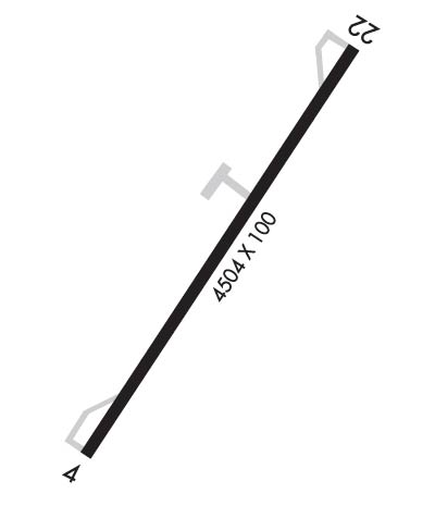
Runway Identifications
Runway Identification: 04/22Length: 4504 ft
Width: 100 ft
Surface: ASPHALT-FAIR CONDITION
Edge lights: Medium IntensityTreatment: NONE
Weight: PCN 11 /F/C/Y/T
| | Runway: 04 | | Runway: 22 |
| Mag heading: | 43° | Mag heading: | 223° |
| Rwy Slope: | -.04% Down | Rwy Slope: | .04% Up |
| Approach: | | Approach: | |
| Pattern: | Right Traffic | Pattern: | Right Traffic |
| Markings: | NONPRECISION INSTRUMENT | Markings: | NONPRECISION INSTRUMENT |
| Marking Condition: | FAIR | Marking Condition: | FAIR |
| Arresting Dev: | | Arresting Dev: | |
| Lat & Long: | N3410.6 W07920.3 | Lat. & Long.: | N3411.2 W07919.8 |
| Elev: | 92.0 ft. MSL | Elev: | 90.3 ft. MSL |
| TCH: | 39 ft. AGL | TCH: | 39 ft. AGL |
| Visual Glide Path: | 3.00 degrees | Visual Glide Path: | 3.00 degrees |
| Displaced Threshold: | No | Displaced Threshold: | No |
| Touchdown Zone: | YES | Touchdown Zone: | YES |
| Touchdown Elev.: | 92.3 feet | Touchdown Elev.: | 90.4 feet |
| Visual Glide Slope: | 2-Light PAPI on LEFT side of Runway | Visual Glide Slope: | 2-Light PAPI on LEFT side of Runway |
| RVR Equipment: | | RVR Equipment: | |
| RVV Equipment: | NO | RVV Equipment: | NO |
| Approach Lights: | | Approach Lights: | |
| REIL: | NO | REIL: | NO |
| Centerline Lights: | NO | Centerline Lights: | NO |
| Touchdown lights: | NO | Touchdown lights: | NO |
| Runway Category: | Runway with a Non-precision Approach having visibility minimums greater than 3/4 mile | Runway Category: | Runway with a Visual Approach |
| Declared Distances: | | Declared Distances: | |
| Obstructions: | TREE | Obstructions: | TREE |
| Marked: | NOT Marked/Lighted | Marked: | NOT Marked/Lighted |
| Clearance slope: | 29:1 | Clearance slope: | 15:1 |
| Obstruction height: | 57 feet AGL | Obstruction height: | 43 feet AGL |
| Dist. from runway: | 1889 feet | Dist. from runway: | 882 feet |
| Centerline offset: | 377 right of centerline | Centerline offset: | 94 feet left of centerline |
| Comments: | | Comments: | 9 FT HIGH BRUSH 133 FT FROM THRESHOLD 129 FT LEFT OF CENTRLN |

