
| ||||||||||||||||||||||||||||||||||||||||||||||||||||||||||||||||||||
| ||||||||||||||||||||||||||||||||||||||||||||||||||||||||||||||||||||
| Rwy | Rwy | |||||||
| 4694x100 | 4439' | 111.90 - 104° | 4694x100 | 4440' | ||||
| Runway ID | Single Wheel | Double Wheel | Double Tandem Wheel | Dual Double Wheel |
| 10/28 | 20,000 | N/A | N/A | N/A |
| These numbers are Advisory and are not limits. The Airport Manager should have more accurate Weight Limits | ||||
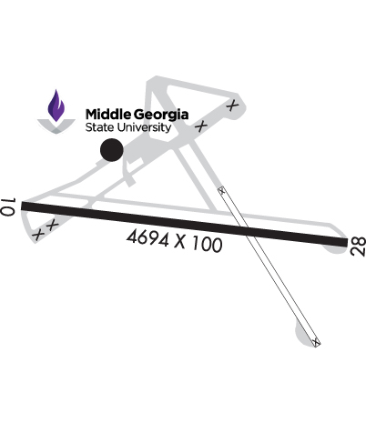 Airport Diagram might not be current. | |
| Facility Name: | MACON DOWNTOWN |
| City Name: | MACON |
| County: | BIBB |
| State abbrev: | GA |
| State Name: | GEORGIA |
| Ownership: | PUBLICLY OWNED |
| Use: | OPEN TO THE PUBLIC |
| Owner's Name: | MACON-BIBB COUNTY CONSOLIDATED GOVT |
| Address: | 700 POPULAR STREET |
| MACON, GA 31201 | |
| Owner's Phone: | 478-751-7170 |
| Manager's Name: | DOUG FAOUR |
| Address: | 1000 TERMINAL DRIVE, SUITE 100; MIDDLE GEORGIA REGIONAL ARPT |
| MACON, GA 31297 | |
| Phone: | 478-803-0460 |
| FAA Region: | SOUTHERN |
| FAA Field Office: | ATL |
| Date | Sunrise | Sunset |
|---|---|---|
| 04/18/24 Thursday | 7:00 | 20:07 |
| 04/19/24 Friday | 6:59 | 20:08 |
| 04/20/24 Saturday | 6:58 | 20:09 |
| 04/21/24 Sunday | 6:57 | 20:09 |
| 04/22/24 Monday | 6:56 | 20:10 |
| 04/23/24 Tuesday | 6:55 | 20:11 |
| 04/24/24 Wednesday | 6:53 | 20:12 |
| 04/25/24 Thursday | 6:52 | 20:12 |
| 04/26/24 Friday | 6:51 | 20:13 |
| 04/27/24 Saturday | 6:50 | 20:14 |
| 04/28/24 Sunday | 6:49 | 20:14 |
| 04/29/24 Monday | 6:48 | 20:15 |
| 04/30/24 Tuesday | 6:47 | 20:16 |
| 05/01/24 Wednesday | 6:46 | 20:17 |
| Airport Attendance Schedule | 7 Days A Week 0700-1900; PHONE AHEAD FOR SPECIAL REQUEST. AFTER HRS CALL OUT FEES MAY APPLY. |
| Airport Status | OPERATIONAL (This Status can change at any time - please check NOTAMS) |
| Airport Lighting Schedule | ACTVT MIRL AND PAPI RY 10/28 - CTAF. |
| Airport Storage Available | Tie Downs |
| Extra Services Available | Flight Instruction |
| Wind Indicator | YES - (lighted) |
| Control Tower | NO |
| CTAF Frequency | 123.000 |
| Unicom Frequency | 123.000 |
| Rotating Beacon Color | WG |
| Segmented Circle | YES |
| Landing Fee | YES; FOR CERTAIN SVCS. |
| Airport Inspected | STATE - performed by STATE AERONAUTICAL PERSONNEL |
| Inspection Date | 05/19/2023 |
| Type of Fuel Available | Grade 100LL, JET A |
| Airframe Repair Service | NONE |
| Power Plant Repair Service | NONE |
| Latitude | N3249.3 |
| Longitude | W08333.7 (ESTIMATED) |
| Arpt Elevation | 436ft (SURVEYED) |
| Magnetic Variation | 06W |
| 3 miles SE | of MACON |
| Traffic Pattern Altitude | |
| Sectional Chart | ATLANTA |
| Operations (Reported) | Yearly | Avg. Daily |
|---|---|---|
| General Aviation Transient | 7000 | 19 |
| General Aviation Local | 16000 | 44 |
| Air Taxi | 0 | 0 |
| Commerical | 0 | 0 |
| Commuter | 0 | 0 |
| Military | 100 | 0 |
| Aircraft based on Field | |
|---|---|
| General Aviation Singles | 18 |
| General Aviation Multi | 5 |
| Jet Aircraft | 0 |
| General Aviation Helicopters | 3 |
| Military Aircraft | 0 |
| Gliders | 0 |
| Ultralights | 0 |
| FSS on field | NO |
| FSS tie-in | MACON |
| FSS Phone | 1-800-WX-BRIEF |
| Who issues Notams | MCN |
| Notam D service at airport | YES |
| ARTCC Name | ATLANTA |
| Airport Certification | |
| Aircraft Rescue & Firefighting Index | None |
| Airport of Entry | No |
| Custom Landing Rights | No |
| Joint Civil/Military | No |
| Military Landing rights | YES |
| NATIONAL PLAN OF INTEGRATED AIRPORT SYSTEMS (NPIAS) |
| GRANT AGREEMENTS UNDER FAAP/ADAP/AIP |
| ASSURANCES PURSUANT TO TITLE VI, CIVIL RIGHTS ACT OF 1964 |
| AGREEMENT UNDER DLAND OR DCLA HAS EXPIRED. |
| 825 FT MSL RADIO TWR LCTD APRXLY 1 MILE SE OF ARPT. |
| POSSIBLE STANDING WATER ON RY 10/28 DURING AND AFTER HEAVY RAIN. |
| WILDLIFE NEAR ARPT. |
| PDEW ADJ TO MOVEMENT AREAS FRM APR 1 TO NOV 1 FOR GRASS CUTTING. |
| FOR CD CTC ATLANTA APCH AT 678-364-6132, WHEN APCH CLSD CTC ATLANTA ARTCC AT 770-210-7692. |
| TWY A UNUSBL BY A/C GTR THAN 49 FT WINGSPAN WHILE ACFT ARR OR DEP ON RWY 10/28. |
Airport Communications & Frequencies:
| |||||||||||||||||||||
| Runway: 10 | Runway: 28 | ||
| Mag heading: | 102° | Mag heading: | 282° |
| Rwy Slope: | .05% Up | Rwy Slope: | -.05% Down |
| Approach: | LOC/DME | Approach: | |
| Pattern: | Left Traffic | Pattern: | Right Traffic |
| Markings: | NONPRECISION INSTRUMENT | Markings: | NONPRECISION INSTRUMENT |
| Marking Condition: | FAIR | Marking Condition: | FAIR |
| Arresting Dev: | Arresting Dev: | ||
| Lat & Long: | N3249.4 W08334.3 | Lat. & Long.: | N3249.3 W08333.3 |
| Elev: | 409.3 ft. MSL | Elev: | 411.8 ft. MSL |
| TCH: | 23 ft. AGL | TCH: | 23 ft. AGL |
| Visual Glide Path: | 3.00 degrees | Visual Glide Path: | 3.00 degrees |
| Displaced Threshold: | 255 feet | Displaced Threshold: | 254 feet |
| Touchdown Zone: | YES | Touchdown Zone: | YES |
| Touchdown Elev.: | 429.9 feet | Touchdown Elev.: | 429.9 feet |
| Visual Glide Slope: | 4-Light PAPI on RIGHT side of Runway | Visual Glide Slope: | 4-Light PAPI on LEFT side of Runway; RWY 28 PAPI UNUSBL BYD 7 DEG RT OF RCL. |
| RVR Equipment: | RVR Equipment: | ||
| RVV Equipment: | NO | RVV Equipment: | NO |
| Approach Lights: | Approach Lights: | ||
| REIL: | NO | REIL: | NO |
| Centerline Lights: | NO | Centerline Lights: | NO |
| Touchdown lights: | NO | Touchdown lights: | NO |
| Runway Category: | Runway with a Non-precision Approach having visibility minimums greater than 3/4 mile | Runway Category: | Runway with a Non-precision Approach having visibility minimums greater than 3/4 mile |
| Declared Distances: | TORA:4694' TODA:4694' ASDA:4439' LDA:4184' | Declared Distances: | TORA:4694' TODA:4694' ASDA:4439' LDA:4184' |


