Approach Charts
| FltPlan does not have IFR approach charts available for KM93. |
Current Weather/Notams (Metars, TAFs, Notams, NWS Forecast, PIREPS, and nearby weather)
Customs Information Send updates to Support@FltPlan.com
Customs Not Available
Database effective 05/16/2024
Airport Diagram might not be current.
|
| Facility Name: | HOUSTON COUNTY |
| City Name: | MC KINNON |
| County: | HOUSTON |
| State abbrev: | TN |
| State Name: | TENNESSEE |
| | |
| Ownership: | PUBLICLY OWNED |
| Use: | OPEN TO THE PUBLIC |
| Owner's Name: | HOUSTON COUNTY |
| Address: | COUNTY COURTHOUSE |
| | ERIN, TN 37061 |
| Owner's Phone: | 931-289-3633 |
| | |
| Manager's Name: | JOEY BRAKE HOUSTON CNTY MAYOR |
| Address: | COUNTY COURTHOUSE, P.O. BOX 366 |
| | ERIN, TN 37061 |
| Phone: | 931-289-3633 |
| | |
| FAA Region: | SOUTHERN |
| FAA Field Office: | MEM |
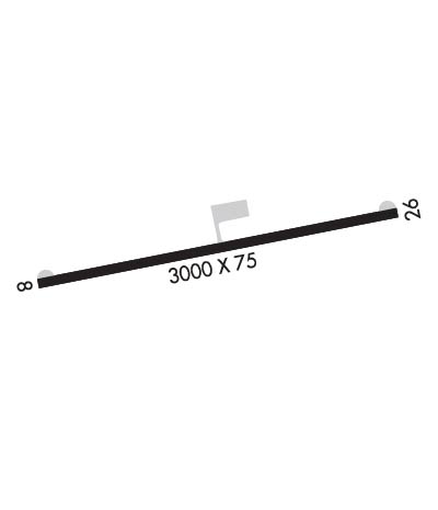
Runway Identifications
Runway Identification: 08/26Length: 3000 ft
Width: 75 ft
Surface: ASPHALT-GOOD CONDITION
Edge lights: Treatment: NONE
| | Runway: 08 | | Runway: 26 |
| Mag heading: | N/A | Mag heading: | N/A |
| Approach: | | Approach: | |
| Pattern: | Left Traffic | Pattern: | Left Traffic |
| Markings: | BASIC | Markings: | BASIC |
| Marking Condition: | FAIR | Marking Condition: | FAIR |
| Arresting Dev: | | Arresting Dev: | |
| Lat & Long: | | Lat. & Long.: | |
| Elev: | N/A | Elev: | N/A |
| TCH: | | TCH: | |
| Visual Glide Path: | | Visual Glide Path: | |
| Displaced Threshold: | No | Displaced Threshold: | No |
| Touchdown Zone: | NO | Touchdown Zone: | NO |
| Touchdown Elev.: | | Touchdown Elev.: | |
| Visual Glide Slope: | | Visual Glide Slope: | |
| RVR Equipment: | | RVR Equipment: | |
| RVV Equipment: | NO | RVV Equipment: | NO |
| Approach Lights: | | Approach Lights: | |
| REIL: | NO | REIL: | NO |
| Centerline Lights: | NO | Centerline Lights: | NO |
| Touchdown lights: | NO | Touchdown lights: | NO |
| Runway Category: | Runway with a Visual Approach | Runway Category: | Runway with a Visual Approach |
| Declared Distances: | | Declared Distances: | |
| Obstructions: | TREES; RY 08 TREES ALONG ROAD NEAR ROW OF HOUSES VIOLATE 7:1 TRANSITIONAL SFC. | Obstructions: | TREES |
| Marked: | NOT Marked/Lighted | Marked: | NOT Marked/Lighted |
| Clearance slope: | 8:1 | Clearance slope: | 7:1; RY 26 TREES ON SOUTH SIDE OF THLD VIOLATE 7:1 TRANSITIONAL SFC. |
| Obstruction height: | 59 feet AGL | Obstruction height: | 79 feet AGL |
| Dist. from runway: | 675 feet | Dist. from runway: | 809 feet |
| Centerline offset: | 119 right of centerline | Centerline offset: | 129 feet left of centerline |
| Comments: | | Comments: | |

