Current Weather/Notams (Metars, TAFs, Notams, NWS Forecast, PIREPS, and nearby weather)
Customs Information Send updates to Support@FltPlan.com
Customs Not Available
Database effective 05/16/2024
Airport Diagram might not be current.
|
| Facility Name: | HOWARD COUNTY |
| City Name: | NASHVILLE |
| County: | HOWARD |
| State abbrev: | AR |
| State Name: | ARKANSAS |
| | |
| Ownership: | PUBLICLY OWNED |
| Use: | OPEN TO THE PUBLIC |
| Owner's Name: | HOWARD COUNTY |
| Address: | 421 N. MAIN |
| | NASHVILLE, AR 71852 |
| Owner's Phone: | 870-845-7500 |
| | |
| Manager's Name: | MARK WILEY |
| Address: | 421 N MAIN |
| | NASHVILLE, AR 71852 |
| Phone: | 870-904-0733 |
| | |
| FAA Region: | SOUTHWEST |
| FAA Field Office: | AOK |
Runway Identifications
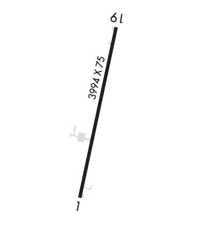
Runway Identification: 01/19Length: 3994 ft
Width: 75 ft
Surface: ASPHALT-FAIR CONDITION
Edge lights: Medium IntensityTreatment: NONE
| | Runway: 01 | | Runway: 19 |
| Mag heading: | 10° | Mag heading: | 190° |
| Rwy Slope: | .53% Up | Rwy Slope: | -.53% Down |
| Approach: | | Approach: | |
| Pattern: | Left Traffic | Pattern: | Left Traffic |
| Markings: | NONPRECISION INSTRUMENT | Markings: | NONPRECISION INSTRUMENT |
| Marking Condition: | POOR; MARKINGS FADED RWY 1 | Marking Condition: | POOR; MARKINGS FADED RWY 19 |
| Arresting Dev: | | Arresting Dev: | |
| Lat & Long: | N3359.5 W09350.4 | Lat. & Long.: | N3400.2 W09350.2 |
| Elev: | 528.5 ft. MSL | Elev: | 549.6 ft. MSL |
| TCH: | 40 ft. AGL | TCH: | 40 ft. AGL |
| Visual Glide Path: | 3.00 degrees | Visual Glide Path: | 3.00 degrees |
| Displaced Threshold: | 115 feet | Displaced Threshold: | No |
| Touchdown Zone: | YES | Touchdown Zone: | YES |
| Touchdown Elev.: | 550.0 feet | Touchdown Elev.: | 553.1 feet |
| Visual Glide Slope: | 2-Light PAPI on LEFT side of Runway | Visual Glide Slope: | 2-Light PAPI on LEFT side of Runway |
| RVR Equipment: | | RVR Equipment: | |
| RVV Equipment: | NO | RVV Equipment: | NO |
| Approach Lights: | | Approach Lights: | |
| REIL: | NO | REIL: | NO |
| Centerline Lights: | NO | Centerline Lights: | NO |
| Touchdown lights: | NO | Touchdown lights: | NO |
| Runway Category: | Runway with a Non-precision Approach | Runway Category: | Runway with a Non-precision Approach |
| Declared Distances: | | Declared Distances: | |
| Obstructions: | TREES | Obstructions: | TREES |
| Marked: | NOT Marked/Lighted | Marked: | NOT Marked/Lighted |
| Clearance slope: | 36:1; APCH RATIO 44:1 FM DTHR. | Clearance slope: | 20:1 |
| Obstruction height: | 40 feet AGL | Obstruction height: | 15 feet AGL |
| Dist. from runway: | 1650 feet | Dist. from runway: | 500 feet |
| Centerline offset: | 525 right of centerline | Centerline offset: | 95 feet left of centerline |
| Comments: | +3 FT FENCE 183 FT FROM RWY END. | Comments: | |

