Click here for more info on on SMS!

KM60

WOODRUFF COUNTY
AUGUSTA
AR
Time Zone: Central
Lat: N 3516.3
Long: W 09116.2
Elev: 200
Var: +01
Longest Runway: 3797
CTAF: 122.9

FBO & Flight Services info for KM60

FBOs: Update your Fuel Prices

AIRPORTPh: 870-731-5516
-
Freq: 122.9
Service
Jet
100LL
SAF
MoGas
Fuel Avail: NO FUEL AVAILABLE
Full        Last Update: 04/18/2024 05:44:57

Self        
If you are an FBO, call 1-203-262-1700 to update your info or email: FltPlan.Advertising@garmin.com
Advertise your FBO on FltPlan.com

Runway & Approach Info for KM60
Rwy
Length
Land Dist**
Approach*
  Rwy
Length
Land Dist**
Approach*
09
3797x75  3797'          
 
  
27
  3797x75  3797'          
 
 * only ILS, LOC, LDA, and SDF approaches to a specific runway are shown
** For any Declared Landing Distance Available, please see A/FD or Approach plates
Runway Weight Capability (lbs.) Help
Runway IDSingle WheelDouble WheelDouble Tandem WheelDual Double Wheel
09/27N/AN/AN/AN/A
These numbers are Advisory and are not limits.   The Airport Manager should have more accurate Weight Limits
Approach Charts
Approaches    
Current Weather/Notams
Customs Information Send updates to Support@FltPlan.com
Customs Not Available
Database effective 04/18/2024
Airport Diagram of KM60
Airport Diagram might not be current.

Facility Name: WOODRUFF COUNTY
City Name: AUGUSTA
County: WOODRUFF
State abbrev: AR
State Name: ARKANSAS
   
Ownership: PUBLICLY OWNED
Use: OPEN TO THE PUBLIC
Owner's Name: WOODRUFF COUNTY
Address: P.O. BOX 300
 AUGUSTA, AR 72006
Owner's Phone: 870-347-5206
  
Manager's Name: MICHAEL-JOHN GRAY - CO. JUDGE
Address: P.O. BOX 300
 AUGUSTA, AR 72006
Phone: 870-731-5516
   
FAA Region: SOUTHWEST
FAA Field Office: AOK


Sunrise / Sunset times for WOODRUFF COUNTY

DateSunriseSunset
04/17/24 Wednesday6:2919:40
04/18/24 Thursday6:2819:41
04/19/24 Friday6:2719:42
04/20/24 Saturday6:2619:43
04/21/24 Sunday6:2419:43
04/22/24 Monday6:2319:44
04/23/24 Tuesday6:2219:45
04/24/24 Wednesday6:2119:46
04/25/24 Thursday6:2019:47
04/26/24 Friday6:1819:48
04/27/24 Saturday6:1719:48
04/28/24 Sunday6:1619:49
04/29/24 Monday6:1519:50
04/30/24 Tuesday6:1419:51

Airport Facilities

Airport Attendance ScheduleUNATTENDED
Airport Status OPERATIONAL (This Status can change at any time - please check NOTAMS)
Airport Lighting ScheduleACTVT MIRL RY 09/27 - CTAF.
Airport Storage AvailableTie Downs
Extra Services AvailableCrop Dusting
Wind IndicatorYES - (lighted)
Control TowerNO
CTAF Frequency122.900
Unicom Frequency
Rotating Beacon ColorWG
Segmented CircleYES
Landing FeeNO

Airport Inspection Data

Airport InspectedSTATE - performed by STATE AERONAUTICAL PERSONNEL
Inspection Date03/23/2023

Airport Services

Type of Fuel AvailableNone
Airframe Repair ServiceNONE
Power Plant Repair ServiceNONE

Geographic Data

LatitudeN3516.3
LongitudeW09116.2 (ESTIMATED)
Arpt Elevation200ft (SURVEYED)
Magnetic Variation01W
4 miles Eof AUGUSTA
Traffic Pattern Altitude
Sectional ChartMEMPHIS

Aircraft Data

Operations (Reported)YearlyAvg. Daily
General Aviation Transient 5001
General Aviation Local 500014
Air Taxi 00
Commerical 00
Commuter 00
Military 00
Aircraft based on Field
General Aviation Singles 0
General Aviation Multi 0
Jet Aircraft 0
General Aviation Helicopters 0
Military Aircraft 0
Gliders 0
Ultralights 0

FAA Services

FSS on field NO
FSS tie-in JONESBORO
FSS Phone 1-800-WX-BRIEF
Who issues Notams JBR
Notam D service at airport YES
ARTCC Name MEMPHIS

Federal Status

Airport Certification
Aircraft Rescue & Firefighting IndexNone
Airport of EntryNo
Custom Landing RightsNo
Joint Civil/MilitaryNo
Military Landing rightsYES

Federal Agreements

NATIONAL PLAN OF INTEGRATED AIRPORT SYSTEMS (NPIAS)
GRANT AGREEMENTS UNDER FAAP/ADAP/AIP
ASSURANCES PURSUANT TO TITLE VI, CIVIL RIGHTS ACT OF 1964

Remarks

DEER ON & INVOF ARPT.
FOR CD CTC MEMPHIS ARTCC AT 901-368-8453/8449.
Airport Communications & Frequencies:
CTAF Frequency:
122.900
Remarks
  • APCH/DEP SVC PRVDD BY MEMPHIS ARTCC (ZME) ON 135.3/335.8 (BRINKLEY RCAG).
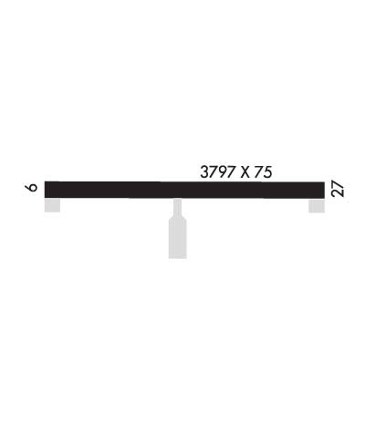
  • Runway Identifications
    Runway Identification: 09/27
    Length: 3797 ft
    Width: 75 ft
    Surface: ASPHALT-GOOD CONDITION
    Edge lights: Medium Intensity

    Treatment: NONE

     Runway: 09   Runway: 27
    Mag heading: N/AMag heading: N/A
    Rwy Slope: .01% UpRwy Slope: -.01% Down
    Approach: Approach:
    Pattern: Left TrafficPattern: Left Traffic
    Markings: NONPRECISION INSTRUMENTMarkings: NONPRECISION INSTRUMENT
    Marking Condition: GOODMarking Condition: GOOD
    Arresting Dev: Arresting Dev:
    Lat & Long: N3516.3  W09116.6Lat. & Long.: N3516.3  W09115.8
    Elev: 197.8 ft. MSLElev: 198.1 ft. MSL
    TCH: 44 ft. AGLTCH: 45 ft. AGL
    Visual Glide Path: 3.00 degreesVisual Glide Path: 3.04 degrees
    Displaced Threshold: NoDisplaced Threshold: No
    Touchdown Zone: YESTouchdown Zone: YES
    Touchdown Elev.: 198.0 feetTouchdown Elev.: 198.1 feet
    Visual Glide Slope: 2-Light PAPI on LEFT side of RunwayVisual Glide Slope: 2-Light PAPI on LEFT side of Runway
    RVR Equipment: RVR Equipment:
    RVV Equipment: NORVV Equipment: NO
    Approach Lights: Approach Lights:
    REIL: NOREIL: NO
    Centerline Lights: NOCenterline Lights: NO
    Touchdown lights: NOTouchdown lights: NO
    Runway Category: Runway with a Visual ApproachRunway Category: Runway with a Visual Approach
    Declared Distances: Declared Distances:
    Obstructions: ROADObstructions: TREES
    Marked: NOT Marked/LightedMarked: NOT Marked/Lighted
    Clearance slope: 25:1Clearance slope: 21:1
    Obstruction height: 4 feet AGLObstruction height: 30 feet AGL
    Dist. from runway: 300 feetDist. from runway: 850 feet
    Centerline offset: Centerline offset: 75 feet right of centerline
    Comments: Comments:
    C:/P: