Click here for more info on on SMS!

KM36

FRANK FEDERER MEMORIAL
BRINKLEY
AR
Time Zone: Central
Lat: N 3452.8
Long: W 09110.6
Elev: 195
Var: -02
Longest Runway: 4002
CTAF: 122.8

FBO & Flight Services info for KM36

FBOs: Update your Fuel Prices

CHISM FLYING SVCPh: 870-734-2779
-
Freq: 122.8
Service
Jet
100LL
SAF
MoGas
Fuel Avail: NO FUEL AVAILABLE
Full        Last Update: 04/15/2024 06:01:01

Self        
FRANK FEDERER APTPh: 870-589-1479 Fax: 870-734-3738 Freq: 122.8
Service
Jet
100LL
SAF
MoGas
Full        Last Update: 04/05/2024 09:57

Self  6.55    
 Address: 630 AIRPORT RD   BRINKLEY AR 72021
If you are an FBO, call 1-203-262-1700 to update your info or email: FltPlan.Advertising@garmin.com
Advertise your FBO on FltPlan.com

Runway & Approach Info for KM36
Rwy
Length
Land Dist**
Approach*
  Rwy
Length
Land Dist**
Approach*
02
4002x75  3754'          
 
  
20
  4002x75  3852'          
 
 * only ILS, LOC, LDA, and SDF approaches to a specific runway are shown
** For any Declared Landing Distance Available, please see A/FD or Approach plates
Runway Weight Capability (lbs.) Help
Runway IDSingle WheelDouble WheelDouble Tandem WheelDual Double Wheel
02/2012,000N/AN/AN/A
These numbers are Advisory and are not limits.   The Airport Manager should have more accurate Weight Limits
Approach Charts
Approaches    
Current Weather/Notams
Customs Information Send updates to Support@FltPlan.com
Customs Not Available
Database effective 04/18/2024
Airport Diagram of KM36
Airport Diagram might not be current.

Facility Name: FRANK FEDERER MEML
City Name: BRINKLEY
County: MONROE
State abbrev: AR
State Name: ARKANSAS
   
Ownership: PUBLICLY OWNED
Use: OPEN TO THE PUBLIC
Owner's Name: CITY OF BRINKLEY
Address: 233 WEST CEDAR
 BRINKLEY, AR 72021
Owner's Phone: 870-734-1382
  
Manager's Name: TERRY BURNETT
Address: 233 WEST CEDAR
 BRINKLEY, AR 72021
Phone: 870-734-5059
   
FAA Region: SOUTHWEST
FAA Field Office: AOK


Sunrise / Sunset times for FRANK FEDERER MEML

DateSunriseSunset
04/15/24 Monday6:3219:38
04/16/24 Tuesday6:3119:39
04/17/24 Wednesday6:2919:39
04/18/24 Thursday6:2819:40
04/19/24 Friday6:2719:41
04/20/24 Saturday6:2619:42
04/21/24 Sunday6:2419:43
04/22/24 Monday6:2319:43
04/23/24 Tuesday6:2219:44
04/24/24 Wednesday6:2119:45
04/25/24 Thursday6:2019:46
04/26/24 Friday6:1919:47
04/27/24 Saturday6:1819:47
04/28/24 Sunday6:1619:48

Airport Facilities

Airport Attendance ScheduleMAR-SEP MON-SAT 0800-1700, OCT-FEB MON-FRI 0800-1700
Airport Status OPERATIONAL (This Status can change at any time - please check NOTAMS)
Airport Lighting ScheduleACTVT MIRL RWY 02/20 - CTAF.
Airport Storage AvailableTie Downs, Hanger
Extra Services AvailableCrop Dusting
Wind IndicatorYES - (lighted)
Control TowerNO
CTAF Frequency122.800
Unicom Frequency122.800
Rotating Beacon ColorWG
Segmented CircleYES
Landing FeeNO

Airport Inspection Data

Airport InspectedSTATE - performed by STATE AERONAUTICAL PERSONNEL
Inspection Date02/08/2022

Airport Services

Type of Fuel AvailableGrade 100LL; -10FUEL AVBL 24 HRS SELF SVC WITH CREDIT CARD.
Airframe Repair ServiceMAJOR
Power Plant Repair ServiceMAJOR

Geographic Data

LatitudeN3452.8
LongitudeW09110.6 (ESTIMATED)
Arpt Elevation195ft (SURVEYED)
Magnetic Variation02E
0 miles SEof BRINKLEY
Traffic Pattern Altitude
Sectional ChartMEMPHIS

Aircraft Data

Operations (Reported)YearlyAvg. Daily
General Aviation Transient 20005
General Aviation Local 2000055
Air Taxi 00
Commerical 00
Commuter 00
Military 1000
Aircraft based on Field
General Aviation Singles 12
General Aviation Multi 0
Jet Aircraft 0
General Aviation Helicopters 0
Military Aircraft 0
Gliders 0
Ultralights 0

FAA Services

FSS on field NO
FSS tie-in JONESBORO
FSS Phone 1-800-WX-BRIEF
Who issues Notams JBR
Notam D service at airport YES
ARTCC Name MEMPHIS

Federal Status

Airport Certification
Aircraft Rescue & Firefighting IndexNone
Airport of EntryNo
Custom Landing RightsNo
Joint Civil/MilitaryNo
Military Landing rightsYES

Federal Agreements

NATIONAL PLAN OF INTEGRATED AIRPORT SYSTEMS (NPIAS)
GRANT AGREEMENTS UNDER FAAP/ADAP/AIP
ASSURANCES PURSUANT TO TITLE VI, CIVIL RIGHTS ACT OF 1964

Remarks

WATER-TANK NW.
NUMEROUS AGRICULTURAL ACFT OPNS FM FEB-NOV 500 FT AGL AND BELOW.
FOR CD CTC MEMPHIS ARTCC AT 901-368-8453/8449.
MIGRATORY BIRDS ON & INVOF ARPT
Airport Communications & Frequencies:
CTAF Frequency:
122.800
Unicom Frequency:
122.800
Remarks
  • APCH/DEP SVC PRVDD BY MEMPHIS ARTCC ON FREQS 135.3/335.8(BRINKLEY RCAG).
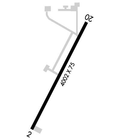
  • Runway Identifications
    Runway Identification: 02/20
    Length: 4002 ft
    Width: 75 ft
    Surface: ASPHALT-GOOD CONDITION
    Edge lights: Medium Intensity

    Treatment: NONE

     Runway: 02   Runway: 20
    Mag heading: 24°Mag heading: 204°
    Rwy Slope: -.11% DownRwy Slope: .11% Up
    Approach: Approach:
    Pattern: Right TrafficPattern: Left Traffic
    Markings: NONPRECISION INSTRUMENTMarkings: NONPRECISION INSTRUMENT
    Marking Condition: GOODMarking Condition: GOOD
    Arresting Dev: Arresting Dev:
    Lat & Long: N3452.5  W09110.8Lat. & Long.: N3453.1  W09110.4
    Elev: 195.1 ft. MSLElev: 190.6 ft. MSL
    TCH: 45 ft. AGLTCH: 48 ft. AGL
    Visual Glide Path: 3.00 degreesVisual Glide Path: 3.00 degrees
    Displaced Threshold: 248 feetDisplaced Threshold: 150 feet
    Touchdown Zone: YESTouchdown Zone: YES
    Touchdown Elev.: 194.7 feetTouchdown Elev.: 194.2 feet
    Visual Glide Slope: 2-Light PAPI on LEFT side of Runway; PAPI UNUSBL BYD 5 DEGS LEFT OF CNTRLN.Visual Glide Slope: 2-Light PAPI on LEFT side of Runway; PAPI UNUSBL BYD 4 DEGS LEFT OF CNTRLN AND BYD 7 DEGS RIGHT OF CNTRLN.
    RVR Equipment: RVR Equipment:
    RVV Equipment: NORVV Equipment: NO
    Approach Lights: Approach Lights:
    REIL: NOREIL: NO
    Centerline Lights: NOCenterline Lights: NO
    Touchdown lights: NOTouchdown lights: NO
    Runway Category: Runway with a Visual ApproachRunway Category: Runway with a Non-precision Approach
    Declared Distances: Declared Distances:
    Obstructions: POLEObstructions: TREE
    Marked: NOT Marked/LightedMarked: NOT Marked/Lighted
    Clearance slope: 13:1; APCH SLOPE 30:1 TO DSPLCD THLD.Clearance slope: 21:1; APCH SLOPE 32:1 TO DSPLCD THLD.
    Obstruction height: 25 feet AGLObstruction height: 50 feet AGL
    Dist. from runway: 525 feetDist. from runway: 1250 feet
    Centerline offset: 200 left of centerlineCenterline offset: 130 feet right of centerline
    Comments: ROAD & BRIDGE SIGNS AT 180 FT FM THR XNG CNTRLN.Comments:
    C:1/P: