Current Weather/Notams (Metars, TAFs, Notams, NWS Forecast, PIREPS, and nearby weather)
Customs Information Send updates to Support@FltPlan.com
Customs Not Available
Database effective 05/16/2024
Airport Diagram might not be current.
|
| Facility Name: | BILL PUGH FLD |
| City Name: | RUSSELLVILLE |
| County: | FRANKLIN |
| State abbrev: | AL |
| State Name: | ALABAMA |
| | |
| Ownership: | PUBLICLY OWNED |
| Use: | OPEN TO THE PUBLIC |
| Owner's Name: | CITY OF RUSSELLVILLE |
| Address: | PO BOX 1000 |
| | RUSSELLVILLE, AL 35653 |
| Owner's Phone: | 256-332-6060 |
| | |
| Manager's Name: | EMILY EVANS; RICHARD J. TUTICH, CHAIRMAN 256-332-6569. |
| Address: | 13365 HWY 243 |
| | RUSSELLVILLE, AL 35654-7605 |
| Phone: | 256-412-5225; ARPT NR 256-331-9000. |
| | |
| FAA Region: | SOUTHERN |
| FAA Field Office: | JAN |
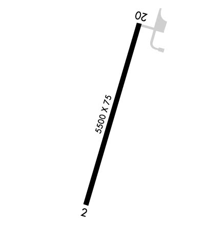
Runway Identifications
Runway Identification: 02/20Length: 5500 ft
Width: 75 ft
Surface: ASPHALT-FAIR CONDITION
Edge lights: Medium IntensityTreatment: NONE
| | Runway: 02 | | Runway: 20 |
| Mag heading: | 18° | Mag heading: | 198° |
| Rwy Slope: | .55% Up | Rwy Slope: | -.55% Down |
| Approach: | | Approach: | |
| Pattern: | Left Traffic | Pattern: | Left Traffic |
| Markings: | NONPRECISION INSTRUMENT | Markings: | NONPRECISION INSTRUMENT |
| Marking Condition: | POOR; RWY MARKINGS OBSC. | Marking Condition: | POOR; RWY MARKINGS OBSC. |
| Arresting Dev: | | Arresting Dev: | |
| Lat & Long: | N3426.3 W08742.9 | Lat. & Long.: | N3427.1 W08742.5 |
| Elev: | 687.4 ft. MSL | Elev: | 717.6 ft. MSL |
| TCH: | | TCH: | 40 ft. AGL |
| Visual Glide Path: | | Visual Glide Path: | 3.00 degrees |
| Displaced Threshold: | No | Displaced Threshold: | 500 feet |
| Touchdown Zone: | YES | Touchdown Zone: | YES |
| Touchdown Elev.: | 696.1 feet | Touchdown Elev.: | 717.0 feet |
| Visual Glide Slope: | | Visual Glide Slope: | 4-Light PAPI on LEFT side of Runway |
| RVR Equipment: | | RVR Equipment: | |
| RVV Equipment: | NO | RVV Equipment: | NO |
| Approach Lights: | | Approach Lights: | |
| REIL: | YES | REIL: | YES |
| Centerline Lights: | NO | Centerline Lights: | NO |
| Touchdown lights: | NO | Touchdown lights: | NO |
| Runway Category: | Runway with a Visual Approach | Runway Category: | Runway with a Visual Approach |
| Declared Distances: | TORA:5000' TODA:5000' ASDA:5500' LDA:5500' | Declared Distances: | TORA:5500' TODA:5500' ASDA:5500' LDA:5000' |
| Obstructions: | TREES | Obstructions: | TREES |
| Marked: | NOT Marked/Lighted | Marked: | NOT Marked/Lighted |
| Clearance slope: | 19:1 | Clearance slope: | 16:1; APCH SLP 29:1 TO DTHR. |
| Obstruction height: | 60 feet AGL | Obstruction height: | 55 feet AGL |
| Dist. from runway: | 1367 feet | Dist. from runway: | 1125 feet |
| Centerline offset: | 225 left of centerline | Centerline offset: | 82 feet left of centerline |
| Comments: | | Comments: | |

