Current Weather/Notams (Metars, TAFs, Notams, NWS Forecast, PIREPS, and nearby weather)
Customs Information Send updates to Support@FltPlan.com
Customs Not Available
Database effective 05/16/2024
Airport Diagram might not be current.
|
| Facility Name: | MUHLENBERG COUNTY |
| City Name: | GREENVILLE |
| County: | MUHLENBERG |
| State abbrev: | KY |
| State Name: | KENTUCKY |
| | |
| Ownership: | PUBLICLY OWNED |
| Use: | OPEN TO THE PUBLIC |
| Owner's Name: | MUHLENBERG COUNTY |
| Address: | MUHLENBERG CO COURTHOUSE |
| | GREENVILLE, KY 42345 |
| Owner's Phone: | 270-338-9419 |
| | |
| Manager's Name: | ED TACKETT |
| Address: | 399 AIRPORT RD |
| | GREENVILLE, KY 42345 |
| Phone: | 270-225-8093 |
| | |
| FAA Region: | SOUTHERN |
| FAA Field Office: | MEM |
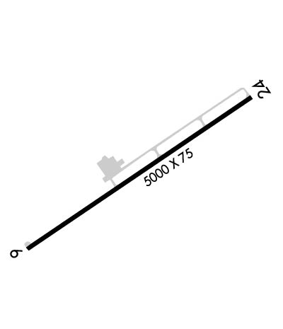
Runway Identifications
Runway Identification: 06/24Length: 4999 ft
Width: 75 ft
Surface: ASPHALT-GOOD CONDITION
Edge lights: Medium IntensityTreatment: NONE
Weight: PCN 6 /F/C/X/T
| | Runway: 06 | | Runway: 24 |
| Mag heading: | 59° | Mag heading: | 239° |
| Rwy Slope: | .27% Up | Rwy Slope: | -.27% Down |
| Approach: | | Approach: | |
| Pattern: | Left Traffic | Pattern: | Left Traffic |
| Markings: | NONPRECISION INSTRUMENT | Markings: | NONPRECISION INSTRUMENT |
| Marking Condition: | GOOD | Marking Condition: | GOOD |
| Arresting Dev: | | Arresting Dev: | |
| Lat & Long: | N3713.3 W08709.8 | Lat. & Long.: | N3713.8 W08709.0 |
| Elev: | 414.8 ft. MSL | Elev: | 428.2 ft. MSL |
| TCH: | 40 ft. AGL | TCH: | 37 ft. AGL |
| Visual Glide Path: | 4.00 degrees | Visual Glide Path: | 4.50 degrees |
| Displaced Threshold: | No | Displaced Threshold: | 400 feet |
| Touchdown Zone: | YES | Touchdown Zone: | YES |
| Touchdown Elev.: | 420.1 feet | Touchdown Elev.: | 425.1 feet |
| Visual Glide Slope: | 2-Light PAPI on LEFT side of Runway | Visual Glide Slope: | 2-Light PAPI on LEFT side of Runway |
| RVR Equipment: | | RVR Equipment: | |
| RVV Equipment: | NO | RVV Equipment: | NO |
| Approach Lights: | | Approach Lights: | |
| REIL: | YES | REIL: | YES |
| Centerline Lights: | NO | Centerline Lights: | NO |
| Touchdown lights: | NO | Touchdown lights: | NO |
| Runway Category: | Runway with a Non-precision Approach having visibility minimums greater than 3/4 mile | Runway Category: | Runway with a Non-precision Approach having visibility minimums greater than 3/4 mile |
| Declared Distances: | | Declared Distances: | TORA:5000' TODA:5000' ASDA:5000' LDA:4600' |
| Obstructions: | TREES | Obstructions: | ROAD |
| Marked: | NOT Marked/Lighted | Marked: | NOT Marked/Lighted |
| Clearance slope: | 17:1 | Clearance slope: | 17:1; 27:1 AT DSPLCD THR. |
| Obstruction height: | 73 feet AGL | Obstruction height: | 62 feet AGL |
| Dist. from runway: | 1501 feet | Dist. from runway: | 1276 feet |
| Centerline offset: | 220 left of centerline | Centerline offset: | 30B |
| Comments: | | Comments: | |

