Click here for more info on on SMS!

KM19

NEWPORT MUNI
NEWPORT
AR
Time Zone: Central
Lat: N 3538.3
Long: W 09110.6
Elev: 239
Var: -00
Longest Runway: 5002
AWOS: 118.15
CTAF: 122.8

FBO & Flight Services info for KM19

FBOs: Update your Fuel Prices
Newport Regional Airport is a full service GA airport with two 5,000 ft. long by 150 ft. wide concrete runways, taxiways and ramps. The 5,000 sq. ft. terminal building was constructed in 2012 and provides flight planning, rest and refreshment areas. The facility is open after-hours with credit card access to Shell 100LL avgas and Jet-A fuel. Full service aircraft maintenance facility is available
Ph: 870-523-3613 Fax: 870-523-3613 Freq: 122.8WebsiteE-Mail
Service
Jet
100LL
SAF
MoGas
Fuel Avail: PRIST PREMIXED, SELF SERV FUEL AFTER HRS ONLY,
Full4.925.75    Last Update: 04/05/2024 13:48
PRICES GUARANTEED by FBO.
Self4.925.75    
Misc. Info: Address: 8502 VICTORY BLVD   NEWPORT, AR 72112

ASOSPh: 870-523-2189
-
Freq: 118.15  
If you are an FBO, call 1-203-262-1700 to update your info or email: FltPlan.Advertising@garmin.com
Advertise your FBO on FltPlan.com

Runway & Approach Info for KM19
Rwy
Length
Land Dist**
Approach*
  Rwy
Length
Land Dist**
Approach*
04
5002x150  5002'          
 
  
22
  5002x150  5002'          
 
18
5002x150  5002'          
 
  
36
  5002x150  5002'          
 
 * only ILS, LOC, LDA, and SDF approaches to a specific runway are shown
** For any Declared Landing Distance Available, please see A/FD or Approach plates
Runway Weight Capability (lbs.) Help
Runway IDSingle WheelDouble WheelDouble Tandem WheelDual Double Wheel
04/2230,000N/AN/AN/A
18/3630,000N/AN/AN/A
These numbers are Advisory and are not limits.   The Airport Manager should have more accurate Weight Limits
Approach Charts
Approaches    
Current Weather/Notams
Customs Information Send updates to Support@FltPlan.com
Customs Not Available
Database effective 04/18/2024
Airport Diagram of KM19
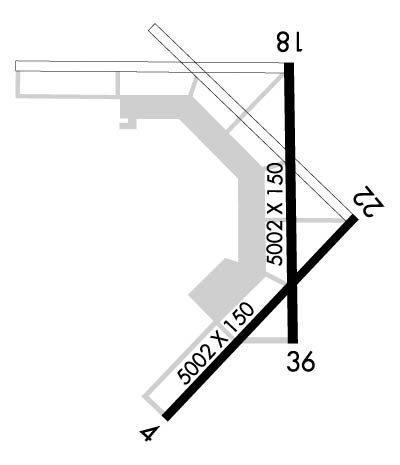
Airport Diagram might not be current.

Facility Name: NEWPORT RGNL
City Name: NEWPORT
County: JACKSON
State abbrev: AR
State Name: ARKANSAS
   
Ownership: PUBLICLY OWNED
Use: OPEN TO THE PUBLIC
Owner's Name: CITY OF NEWPORT
Address: 615 3RD ST
 NEWPORT, AR 72112
Owner's Phone: 870-523-6568
  
Manager's Name: THOMAS SANDERS
Address: 3800 OPERATIONS DRIVE
 NEWPORT, AR 72112
Phone: 870-523-3613
   
FAA Region: SOUTHWEST
FAA Field Office: AOK


Sunrise / Sunset times for NEWPORT RGNL

DateSunriseSunset
04/18/24 Thursday6:2719:41
04/19/24 Friday6:2619:42
04/20/24 Saturday6:2519:43
04/21/24 Sunday6:2319:44
04/22/24 Monday6:2219:44
04/23/24 Tuesday6:2119:45
04/24/24 Wednesday6:2019:46
04/25/24 Thursday6:1919:47
04/26/24 Friday6:1719:48
04/27/24 Saturday6:1619:49
04/28/24 Sunday6:1519:49
04/29/24 Monday6:1419:50
04/30/24 Tuesday6:1319:51
05/01/24 Wednesday6:1219:52

Airport Facilities

Airport Attendance ScheduleMON-FRI 0800-1700, SAT 0800-1200; FOR SVC AFT HRS CALL 870-217-1400
Airport Status OPERATIONAL (This Status can change at any time - please check NOTAMS)
Airport Lighting ScheduleDUSK-DAWN. ACTVT MIRL RWY 18/36 - CTAF
Airport Storage AvailableTie Downs
Extra Services AvailableCrop Dusting, Flight Instruction
Wind IndicatorYES - (lighted)
Control TowerNO
CTAF Frequency122.800
Unicom Frequency122.800
Rotating Beacon ColorWG
Segmented CircleNO
Landing FeeNO

Airport Inspection Data

Airport InspectedSTATE - performed by STATE AERONAUTICAL PERSONNEL
Inspection Date03/02/2022

Airport Services

Type of Fuel AvailableGrade 100LL, JET A (freeze point -40C); -10SELF SVC FUEL AVBL AFT HRS WITH CREDIT CARD JET A & 100LL.
Airframe Repair ServiceNONE
Power Plant Repair ServiceNONE

Geographic Data

LatitudeN3538.3
LongitudeW09110.6 (ESTIMATED)
Arpt Elevation238ft (SURVEYED)
Magnetic Variation00E
5 miles NEof NEWPORT
Traffic Pattern Altitude
Sectional ChartMEMPHIS

Aircraft Data

Operations (Reported)YearlyAvg. Daily
General Aviation Transient 700019
General Aviation Local 15004
Air Taxi 00
Commerical 00
Commuter 00
Military 1000
Aircraft based on Field
General Aviation Singles 13
General Aviation Multi 4
Jet Aircraft 1
General Aviation Helicopters 0
Military Aircraft 0
Gliders 0
Ultralights 0

FAA Services

FSS on field NO
FSS tie-in JONESBORO
FSS Phone 1-800-WX-BRIEF
Who issues Notams M19
Notam D service at airport YES
ARTCC Name MEMPHIS

Federal Status

Airport Certification
Aircraft Rescue & Firefighting IndexNone
Airport of EntryNo
Custom Landing RightsNo
Joint Civil/MilitaryNo
Military Landing rightsYES

Federal Agreements

NATIONAL PLAN OF INTEGRATED AIRPORT SYSTEMS (NPIAS)
GRANT AGREEMENTS UNDER FAAP/ADAP/AIP
SURPLUS PROPERTY AGREEMENT UNDER PUBLIC LAW 289
SURPLUS PROPERTY AGREEMENT UNDER REGULATION 16-WAA
ASSURANCES PURSUANT TO TITLE VI, CIVIL RIGHTS ACT OF 1964

Remarks

NUMEROUS AGRICULTURAL OPNS MARCH THRU AUGUST
FOR CD CTC MEMPHIS ARTCC AT 901-368-8453/8449.
Airport Communications & Frequencies:
CTAF Frequency:
122.800
Unicom Frequency:
122.800
Remarks
  • APCH/DEP SVC PRVDD BY MEMPHIS ARTCC ON FREQS 120.075/289.4 (WALNUT RIDGE RCAG).
  • Runway Identifications
    Runway Identification: 04/22
    Length: 5002 ft
    Width: 150 ft
    Surface: CONCRETE-GOOD CONDITION
    Edge lights:

    Treatment: NONE

     Runway: 04   Runway: 22
    Mag heading: 44°Mag heading: 224°
    Rwy Slope: .04% UpRwy Slope: -.04% Down
    Approach: Approach:
    Pattern: Right TrafficPattern: Left Traffic
    Markings: NONPRECISION INSTRUMENTMarkings: NONPRECISION INSTRUMENT
    Marking Condition: GOODMarking Condition: GOOD
    Arresting Dev: Arresting Dev:
    Lat & Long: N3537.8  W09111.0Lat. & Long.: N3538.4  W09110.3
    Elev: 235.0 ft. MSLElev: 237.0 ft. MSL
    TCH: TCH:
    Visual Glide Path: Visual Glide Path:
    Displaced Threshold: NoDisplaced Threshold: No
    Touchdown Zone: YESTouchdown Zone: YES
    Touchdown Elev.: 237.0 feetTouchdown Elev.: 237.0 feet
    Visual Glide Slope: Visual Glide Slope:
    RVR Equipment: RVR Equipment:
    RVV Equipment: NORVV Equipment: NO
    Approach Lights: Approach Lights:
    REIL: NOREIL: NO
    Centerline Lights: NOCenterline Lights: NO
    Touchdown lights: NOTouchdown lights: NO
    Runway Category: Runway with a Visual ApproachRunway Category: Runway with a Visual Approach
    Declared Distances: Declared Distances:
    Runway Identification: 18/36
    Length: 5002 ft
    Width: 150 ft
    Surface: CONCRETE-GOOD CONDITION
    Edge lights: Medium Intensity

    Treatment: NONE

     Runway: 18   Runway: 36
    Mag heading: 181°Mag heading:
    Rwy Slope: .01% UpRwy Slope: -.01% Down
    Approach: Approach:
    Pattern: Left TrafficPattern: Right Traffic
    Markings: NONPRECISION INSTRUMENTMarkings: NONPRECISION INSTRUMENT
    Marking Condition: FAIRMarking Condition: FAIR
    Arresting Dev: Arresting Dev:
    Lat & Long: N3538.8  W09110.5Lat. & Long.: N3538.0  W09110.5
    Elev: 238.4 ft. MSLElev: 238.9 ft. MSL
    TCH: 44 ft. AGLTCH: 44 ft. AGL
    Visual Glide Path: 3.00 degreesVisual Glide Path: 3.00 degrees
    Displaced Threshold: NoDisplaced Threshold: No
    Touchdown Zone: YESTouchdown Zone: YES
    Touchdown Elev.: 238.8 feetTouchdown Elev.: 238.9 feet
    Visual Glide Slope: 4-Light PAPI on LEFT side of RunwayVisual Glide Slope: 4-Light PAPI on RIGHT side of Runway
    RVR Equipment: RVR Equipment:
    RVV Equipment: NORVV Equipment: NO
    Approach Lights: Approach Lights:
    REIL: YESREIL: YES
    Centerline Lights: NOCenterline Lights: NO
    Touchdown lights: NOTouchdown lights: NO
    Runway Category: Runway with a Non-precision Approach having visibility minimums greater than 3/4 mileRunway Category: Runway with a Non-precision Approach having visibility minimums greater than 3/4 mile
    Declared Distances: Declared Distances:
    Obstructions: PLINEObstructions:
    Marked: NOT Marked/LightedMarked:
    Clearance slope: 48:1Clearance slope: 50:1
    Obstruction height: 32 feet AGLObstruction height:
    Dist. from runway: 1740 feetDist. from runway:
    Centerline offset: Centerline offset:
    Comments: Comments:
    C:2/P: