Current Weather/Notams (Metars, TAFs, Notams, NWS Forecast, PIREPS, and nearby weather)
Customs Information Send updates to Support@FltPlan.com
Customs Not Available
Database effective 05/16/2024
Airport Diagram might not be current.
|
| Facility Name: | HOPE MUNI |
| City Name: | HOPE |
| County: | HEMPSTEAD |
| State abbrev: | AR |
| State Name: | ARKANSAS |
| | |
| Ownership: | PUBLICLY OWNED |
| Use: | OPEN TO THE PUBLIC |
| Owner's Name: | CITY OF HOPE |
| Address: | PO BOX 667 |
| | HOPE, AR 71802 |
| Owner's Phone: | 870-777-6701 |
| | |
| Manager's Name: | DARRELL ALLEN |
| Address: | PO BOX 667 |
| | HOPE, AR 71802 |
| Phone: | 870-777-3444 |
| | |
| FAA Region: | SOUTHWEST |
| FAA Field Office: | AOK |
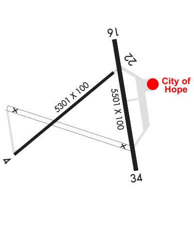
Runway Identifications
Runway Identification: 04/22Length: 5301 ft
Width: 100 ft
Surface: CONCRETE-FAIR CONDITION
Edge lights: Treatment: NONE
| | Runway: 04 | | Runway: 22 |
| Mag heading: | 45° | Mag heading: | 225° |
| Rwy Slope: | .40% Up | Rwy Slope: | -.40% Down |
| Approach: | | Approach: | |
| Pattern: | Left Traffic | Pattern: | Left Traffic |
| Markings: | NONPRECISION INSTRUMENT | Markings: | NONPRECISION INSTRUMENT |
| Marking Condition: | POOR; CNTRLN AND THR MKGS FADED. | Marking Condition: | POOR; CNTRLN AND THR MKGS FADED. |
| Arresting Dev: | | Arresting Dev: | |
| Lat & Long: | N3342.9 W09340.2 | Lat. & Long.: | N3343.5 W09339.4 |
| Elev: | 330.0 ft. MSL | Elev: | 351.0 ft. MSL |
| TCH: | | TCH: | |
| Visual Glide Path: | | Visual Glide Path: | |
| Displaced Threshold: | 1190 feet | Displaced Threshold: | 344 feet |
| Touchdown Zone: | YES | Touchdown Zone: | YES |
| Touchdown Elev.: | 345.8 feet | Touchdown Elev.: | 351.0 feet |
| Visual Glide Slope: | | Visual Glide Slope: | |
| RVR Equipment: | | RVR Equipment: | |
| RVV Equipment: | NO | RVV Equipment: | NO |
| Approach Lights: | | Approach Lights: | |
| REIL: | NO | REIL: | NO |
| Centerline Lights: | NO | Centerline Lights: | NO |
| Touchdown lights: | NO | Touchdown lights: | NO |
| Runway Category: | Runway with a Non-precision Approach having visibility minimums greater than 3/4 mile | Runway Category: | Runway with a Non-precision Approach having visibility minimums greater than 3/4 mile |
| Declared Distances: | | Declared Distances: | |
| Obstructions: | TREES | Obstructions: | |
| Marked: | NOT Marked/Lighted | Marked: | |
| Clearance slope: | 1:1; APCH RATIO FROM DSPLCD THR 28:1. | Clearance slope: | 50:1 |
| Obstruction height: | 50 feet AGL | Obstruction height: | |
| Dist. from runway: | 250 feet | Dist. from runway: | |
| Centerline offset: | | Centerline offset: | |
| Comments: | | Comments: | |
Runway Identification: 16/34Length: 5501 ft
Width: 100 ft
Surface: CONCRETE-GOOD CONDITION
Edge lights: Medium IntensityTreatment: NONE
| | Runway: 16 | | Runway: 34 |
| Mag heading: | 164° | Mag heading: | 344° |
| Rwy Slope: | -.34% Down | Rwy Slope: | .34% Up |
| Approach: | | Approach: | |
| Pattern: | Left Traffic | Pattern: | Left Traffic |
| Markings: | NONPRECISION INSTRUMENT | Markings: | NUMBERS ONLY |
| Marking Condition: | GOOD; CNTRLN AND THR MKGS FADED. | Marking Condition: | GOOD; CNTRLN AND THR MKGS FADED. |
| Arresting Dev: | | Arresting Dev: | |
| Lat & Long: | N3343.7 W09339.4 | Lat. & Long.: | N3342.8 W09339.2 |
| Elev: | 359.2 ft. MSL | Elev: | 340.4 ft. MSL |
| TCH: | 43 ft. AGL | TCH: | 44 ft. AGL |
| Visual Glide Path: | 3.00 degrees | Visual Glide Path: | 3.00 degrees |
| Displaced Threshold: | No | Displaced Threshold: | No |
| Touchdown Zone: | YES | Touchdown Zone: | YES |
| Touchdown Elev.: | 359.2 feet | Touchdown Elev.: | 340.4 feet |
| Visual Glide Slope: | 2-Light PAPI on LEFT side of Runway | Visual Glide Slope: | 2-Light PAPI on LEFT side of Runway |
| RVR Equipment: | | RVR Equipment: | |
| RVV Equipment: | NO | RVV Equipment: | NO |
| Approach Lights: | | Approach Lights: | |
| REIL: | YES | REIL: | YES |
| Centerline Lights: | NO | Centerline Lights: | NO |
| Touchdown lights: | NO | Touchdown lights: | NO |
| Runway Category: | Runway with a Non-precision Approach having visibility minimums greater than 3/4 mile | Runway Category: | Runway with a Visual Approach |
| Declared Distances: | | Declared Distances: | |
| Obstructions: | TREE | Obstructions: | TREES |
| Marked: | NOT Marked/Lighted | Marked: | NOT Marked/Lighted |
| Clearance slope: | 34:1 | Clearance slope: | 34:1 |
| Obstruction height: | 32 feet AGL | Obstruction height: | 29 feet AGL |
| Dist. from runway: | 1300 feet | Dist. from runway: | 1200 feet |
| Centerline offset: | 330 left of centerline | Centerline offset: | |
| Comments: | | Comments: | |

