Click here for more info on on SMS!

KM02

DICKSON MUNI
DICKSON
TN
Time Zone: Central
Lat: N 3607.7
Long: W 08725.8
Elev: 892
Var: +01
Longest Runway: 5001
AWOS: 123.87
CTAF: 122.8

FBO & Flight Services info for KM02

FBOs: Update your Fuel Prices

DICKSON CTY APPh: 615-446-6611
-
Freq: 122.8
Service
Jet
100LL
SAF
MoGas
Fuel Avail: PRIST PREMIXED
Full4.905.59    Last Update: 04/21/2024 12:57

Self        
 Address: 2370 SYLVIA RD   DICKSON, TN 37055
LIBERTY AVIATIONPh: 615-446-5962
-
-
Service
Jet
100LL
SAF
MoGas
Fuel Avail: ~~MAINT. ONLY. NO FUEL SOLD HERE.
Full        Last Update: 04/23/2024 05:40:08

Self        
AWOSPh: 615-446-5481
-
Freq: 123.87  
If you are an FBO, call 1-203-262-1700 to update your info or email: FltPlan.Advertising@garmin.com
Advertise your FBO on FltPlan.com

Runway & Approach Info for KM02
Rwy
Length
Land Dist**
Approach*
  Rwy
Length
Land Dist**
Approach*
17
5001x75  5001'          
 
  
35
  5001x75  5001'          
 
 * only ILS, LOC, LDA, and SDF approaches to a specific runway are shown
** For any Declared Landing Distance Available, please see A/FD or Approach plates
Runway Weight Capability (lbs.) Help
Runway IDSingle WheelDouble WheelDouble Tandem WheelDual Double Wheel
17/3516,00026,000N/AN/A
These numbers are Advisory and are not limits.   The Airport Manager should have more accurate Weight Limits
Approach Charts
Approaches    
Current Weather/Notams
Customs Information Send updates to Support@FltPlan.com
Customs Not Available
Database effective 05/16/2024
Airport Diagram of KM02
Airport Diagram might not be current.

Facility Name: DICKSON MUNI
City Name: DICKSON
County: DICKSON
State abbrev: TN
State Name: TENNESSEE
   
Ownership: PUBLICLY OWNED
Use: OPEN TO THE PUBLIC
Owner's Name: DICKSON COUNTY ARPT AUTHORITY
Address: P.O.BOX 901
 DICKSON, TN 37056
Owner's Phone: 615-446-6611
  
Manager's Name: MIKE GALLAGHER
Address: 2372 SYLVIA RD
 DICKSON, TN 37056
Phone: (615) 812-1981
   
FAA Region: SOUTHERN
FAA Field Office: MEM


Sunrise / Sunset times for DICKSON MUNI

DateSunriseSunset
04/22/24 Monday6:0719:30
04/23/24 Tuesday6:0519:31
04/24/24 Wednesday6:0419:32
04/25/24 Thursday6:0319:33
04/26/24 Friday6:0219:34
04/27/24 Saturday6:0119:34
04/28/24 Sunday5:5919:35
04/29/24 Monday5:5819:36
04/30/24 Tuesday5:5719:37
05/01/24 Wednesday5:5619:38
05/02/24 Thursday5:5519:39
05/03/24 Friday5:5419:40
05/04/24 Saturday5:5319:40
05/05/24 Sunday5:5219:41

Airport Facilities

Airport Attendance Schedule7 Days A Week 0800-1800; AFT HR - AMGR.
Airport Status OPERATIONAL (This Status can change at any time - please check NOTAMS)
Airport Lighting ScheduleSS-SR
Airport Storage AvailableTie Downs
Extra Services AvailableFlight Instruction, Aircraft Rental
Wind IndicatorYES - (lighted)
Control TowerNO
CTAF Frequency122.800
Unicom Frequency122.800
Rotating Beacon ColorWG
Segmented CircleYES
Landing FeeNO

Airport Inspection Data

Airport InspectedSTATE - performed by STATE AERONAUTICAL PERSONNEL
Inspection Date08/23/2021

Airport Services

Type of Fuel AvailableGrade 100LL, JET A
Airframe Repair ServiceMINOR
Power Plant Repair ServiceMAJOR

Geographic Data

LatitudeN3607.7
LongitudeW08725.8 (ESTIMATED)
Arpt Elevation892ft (SURVEYED)
Magnetic Variation01W
3 miles Nof DICKSON
Traffic Pattern Altitude
Sectional ChartST LOUIS

Aircraft Data

Operations (Reported)YearlyAvg. Daily
General Aviation Transient 720020
General Aviation Local 525614
Air Taxi 2401
Commerical 00
Commuter 00
Military 2881
Aircraft based on Field
General Aviation Singles 25
General Aviation Multi 4
Jet Aircraft 1
General Aviation Helicopters 1
Military Aircraft 0
Gliders 0
Ultralights 0

FAA Services

FSS on field NO
FSS tie-in JACKSON
FSS Phone 1-800-WX-BRIEF
Who issues Notams MKL
Notam D service at airport YES
ARTCC Name MEMPHIS

Federal Status

Airport Certification
Aircraft Rescue & Firefighting IndexNone
Airport of EntryNo
Custom Landing RightsNo
Joint Civil/MilitaryNo
Military Landing rightsYES

Federal Agreements

NATIONAL PLAN OF INTEGRATED AIRPORT SYSTEMS (NPIAS)
GRANT AGREEMENT HAS EXPIRED; HOWEVER, AGREEMENT REMAINS IN EFFECT FOR THIS FACILITY AS LONG AS IT IS PUBLIC USE.

Remarks

FOR CD CTC MEMPHIS ARTCC AT 901-368-8453/8449.
Airport Communications & Frequencies:
CTAF Frequency:
122.800
Unicom Frequency:
122.800
Remarks
  • APCH/DEP SVC PRVDD BY MEMPHIS ARTCC ON FREQS 125.85/379.25 (CENTERVILLE RCAG).
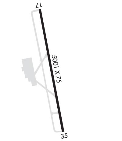
  • Runway Identifications
    Runway Identification: 17/35
    Length: 5001 ft
    Width: 75 ft
    Surface: ASPHALT-GOOD CONDITION
    Edge lights: Medium Intensity

    Treatment: NONE
    Weight: PCN 17 /F/C/X/T

     Runway: 17   Runway: 35
    Mag heading: 173°Mag heading: 353°
    Rwy Slope: -.48% DownRwy Slope: .48% Up
    Approach: Approach:
    Pattern: Left TrafficPattern: Left Traffic
    Markings: NONPRECISION INSTRUMENTMarkings: NONPRECISION INSTRUMENT
    Marking Condition: GOODMarking Condition: GOOD
    Arresting Dev: Arresting Dev:
    Lat & Long: N3608.1  W08725.9Lat. & Long.: N3607.3  W08725.7
    Elev: 892.1 ft. MSLElev: 868.0 ft. MSL
    TCH: TCH:
    Visual Glide Path: Visual Glide Path:
    Displaced Threshold: NoDisplaced Threshold: No
    Touchdown Zone: YESTouchdown Zone: YES
    Touchdown Elev.: 892.1 feetTouchdown Elev.: 871.1 feet
    Visual Glide Slope: Visual Glide Slope:
    RVR Equipment: RVR Equipment:
    RVV Equipment: NORVV Equipment: NO
    Approach Lights: Approach Lights:
    REIL: YESREIL: YES
    Centerline Lights: NOCenterline Lights: NO
    Touchdown lights: NOTouchdown lights: NO
    Runway Category: Runway with a Non-precision Approach having visibility minimums greater than 3/4 mileRunway Category: Runway with a Visual Approach
    Declared Distances: Declared Distances:
    Obstructions: TREESObstructions: TREES
    Marked: NOT Marked/LightedMarked: NOT Marked/Lighted
    Clearance slope: 20:1Clearance slope: 15:1
    Obstruction height: 62 feet AGLObstruction height: 74 feet AGL
    Dist. from runway: 1469 feetDist. from runway: 1332 feet
    Centerline offset: 312 right of centerlineCenterline offset: 308 feet left of centerline
    Comments: Comments:
    C:5/P: