
| ||||||||||||||||||||||||||||||||||||||||||||
| ||||||||||||||||||||||||||||||||||||||||||||
| ||||||||||||||||||||||||||||||||||||||||||||
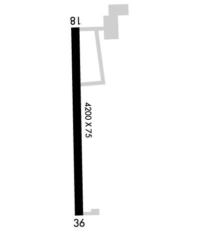
| Rwy | Rwy | |||||||
| 4200x75 | 4200' | 4200x75 | 4200' | |||||
| Runway ID | Single Wheel | Double Wheel | Double Tandem Wheel | Dual Double Wheel |
| 18/36 | 17,000 | 23,000 | N/A | N/A |
| These numbers are Advisory and are not limits. The Airport Manager should have more accurate Weight Limits | ||||
 Airport Diagram might not be current. | |
| Facility Name: | QUENTIN AANENSON FLD |
| City Name: | LUVERNE |
| County: | ROCK |
| State abbrev: | MN |
| State Name: | MINNESOTA |
| Ownership: | PUBLICLY OWNED |
| Use: | OPEN TO THE PUBLIC |
| Owner's Name: | CITY OF LUVERNE |
| Address: | 305 E LUVERNE ST, PO BOX 659 |
| LUVERNE, MN 56156-1611 | |
| Owner's Phone: | 507-449-2388 |
| Manager's Name: | BEN BAUM |
| Address: | 941 US HIGHWAY 75, PO BOX 659 |
| LUVERNE, MN 56156-4197 | |
| Phone: | 507-283-5041; ARPT FONE. |
| FAA Region: | GREAT LAKES |
| FAA Field Office: | DMA |
| Date | Sunrise | Sunset |
|---|---|---|
| 04/15/24 Monday | 6:41 | 20:09 |
| 04/16/24 Tuesday | 6:39 | 20:10 |
| 04/17/24 Wednesday | 6:38 | 20:12 |
| 04/18/24 Thursday | 6:36 | 20:13 |
| 04/19/24 Friday | 6:34 | 20:14 |
| 04/20/24 Saturday | 6:33 | 20:15 |
| 04/21/24 Sunday | 6:31 | 20:16 |
| 04/22/24 Monday | 6:30 | 20:18 |
| 04/23/24 Tuesday | 6:28 | 20:19 |
| 04/24/24 Wednesday | 6:26 | 20:20 |
| 04/25/24 Thursday | 6:25 | 20:21 |
| 04/26/24 Friday | 6:23 | 20:22 |
| 04/27/24 Saturday | 6:22 | 20:24 |
| 04/28/24 Sunday | 6:20 | 20:25 |
| Airport Attendance Schedule | MON-FRI 0800-1700 |
| Airport Status | OPERATIONAL (This Status can change at any time - please check NOTAMS) |
| Airport Lighting Schedule | ACTVT OR INCR INTST REIL RWY 18 & 36; PAPI RWY 18 & 36; MIRL RWY 18/36 - CTAF. RWY LGT PRESET LOW INTST DUSK-DAWN. |
| Airport Storage Available | Tie Downs |
| Extra Services Available | Crop Dusting |
| Wind Indicator | YES - (lighted) |
| Control Tower | NO |
| CTAF Frequency | 122.700 |
| Unicom Frequency | 122.700 |
| Rotating Beacon Color | WG; ABN LWR THAN BLDG NNE. |
| Segmented Circle | NO |
| Landing Fee | NO |
| Airport Inspected | STATE - performed by STATE AERONAUTICAL PERSONNEL |
| Inspection Date | 07/21/2022 |
| Type of Fuel Available | Grade 100LL, JET A (freeze point -40C); -10FUEL AVBL H24 SELF SVC VIA CREDIT CARD. |
| Airframe Repair Service | MAJOR |
| Power Plant Repair Service | MAJOR |
| Latitude | N4337.0 |
| Longitude | W09613.1 (ESTIMATED) |
| Arpt Elevation | 1435ft (SURVEYED) |
| Magnetic Variation | 03E |
| 2 miles S | of LUVERNE |
| Traffic Pattern Altitude | |
| Sectional Chart | OMAHA |
| Operations (Reported) | Yearly | Avg. Daily |
|---|---|---|
| General Aviation Transient | 4475 | 12 |
| General Aviation Local | 3925 | 11 |
| Air Taxi | 0 | 0 |
| Commerical | 0 | 0 |
| Commuter | 0 | 0 |
| Military | 0 | 0 |
| Aircraft based on Field | |
|---|---|
| General Aviation Singles | 15 |
| General Aviation Multi | 0 |
| Jet Aircraft | 0 |
| General Aviation Helicopters | 0 |
| Military Aircraft | 0 |
| Gliders | 0 |
| Ultralights | 0 |
| FSS on field | NO |
| FSS tie-in | PRINCETON |
| FSS Phone | 1-800-WX-BRIEF |
| Who issues Notams | LYV |
| Notam D service at airport | YES |
| ARTCC Name | MINNEAPOLIS |
| Airport Certification | |
| Aircraft Rescue & Firefighting Index | None |
| Airport of Entry | No |
| Custom Landing Rights | No |
| Joint Civil/Military | No |
| Military Landing rights | YES |
| NATIONAL PLAN OF INTEGRATED AIRPORT SYSTEMS (NPIAS) |
| ASSURANCES PURSUANT TO TITLE VI, CIVIL RIGHTS ACT OF 1964 |
| GRANT AGREEMENT HAS EXPIRED; HOWEVER, AGREEMENT REMAINS IN EFFECT FOR THIS FACILITY AS LONG AS IT IS PUBLIC USE. |
| LRG WATERFOWL INVOF ARPT. |
| FOR CD CTC SIOUX FALLS APCH AT 605-336-8651, WHEN APCH CLSD CTC MINNEAPOLIS ARTCC AT 651-463-5588. |
Airport Communications & Frequencies:
| |||||||||||||||||
| Runway: 18 | Runway: 36 | ||
| Mag heading: | 175° | Mag heading: | 355° |
| Rwy Slope: | -.16% Down | Rwy Slope: | .16% Up |
| Approach: | Approach: | ||
| Pattern: | Left Traffic | Pattern: | Left Traffic |
| Markings: | NONPRECISION INSTRUMENT | Markings: | NONPRECISION INSTRUMENT |
| Marking Condition: | GOOD | Marking Condition: | GOOD |
| Arresting Dev: | Arresting Dev: | ||
| Lat & Long: | N4337.4 W09613.1 | Lat. & Long.: | N4336.7 W09613.1 |
| Elev: | 1435.0 ft. MSL | Elev: | 1428.4 ft. MSL |
| TCH: | 28 ft. AGL | TCH: | 28 ft. AGL |
| Visual Glide Path: | 3.00 degrees | Visual Glide Path: | 3.00 degrees |
| Displaced Threshold: | No | Displaced Threshold: | No |
| Touchdown Zone: | YES | Touchdown Zone: | YES |
| Touchdown Elev.: | 1435.0 feet | Touchdown Elev.: | 1432.6 feet |
| Visual Glide Slope: | 4-Light PAPI on LEFT side of Runway | Visual Glide Slope: | 4-Light PAPI on LEFT side of Runway |
| RVR Equipment: | RVR Equipment: | ||
| RVV Equipment: | NO | RVV Equipment: | NO |
| Approach Lights: | Approach Lights: | ||
| REIL: | YES | REIL: | YES |
| Centerline Lights: | NO | Centerline Lights: | NO |
| Touchdown lights: | NO | Touchdown lights: | NO |
| Runway Category: | Runway with a Non-precision Approach having visibility minimums greater than 3/4 mile | Runway Category: | Runway with a Non-precision Approach having visibility minimums greater than 3/4 mile |
| Declared Distances: | Declared Distances: |
