KLYH

LYNCHBURG RGNL- PRESTON GLENN
LYNCHBURG
VA
Time Zone: Eastern
Lat: N 3719.5
Long: W 07912.1
Elev: 938
Var: +08
Longest Runway: 7100
Dept. ATIS: 119.8
Arr. ATIS: 119.8
AWOS: 119.8
Ground: 121.9
Tower: 127.65

FBO & Flight Services info for KLYH

FBOs: Update your Fuel Prices

  click here  
Welcome aboard, FBO Gold Carpet Service with a personal touch: Your transportation plane side & attention to detail. Maintenance issue? No problem; onsite repair for turbine & piston. Over 30,000 sq. ft of Heated Hangar Space. Charter an aircraft or learn to fly. Contact us for details. We look forward to seeing you soon!
Ph: 434-237-7002 Fax: 434-237-5305 Freq: 122.95WebsiteE-Mail
                     
Service
Jet
100LL
SAF
MoGas
Fuel Avail: Jet A Prist Premixed. 6am-10pm / 7days
Full5.956.80    Last Update: 04/11/2024 07:18

Self        
Misc. Info: Contact us for After Hours Service, fee applies WE APPRECIATE YOUR BUSINESSAddress: 970 AIRPORT ROAD.   LYNCHBURG, VA 24502

CITY OF LYNCHBURGPh: 434-455-6090
-
-
Service
Jet
100LL
SAF
MoGas
Fuel Avail: ~~24 HOURS/DAY No Attendant. Please do not park aircraft at fuel pad after fueling
Full        Last Update: 04/26/2024 00:15:41  
Self        
 Address: 350 TERMINAL DRIVE, SUITE 100 LYNCHBURG, VA 24502
ASOSPh: 434-239-0025
-
-
 
If you are an FBO, call 1-203-262-1700 to update your info or email: FltPlan.Advertising@garmin.com
Advertise your FBO on FltPlan.com

Runway & Approach Info for KLYH
Rwy
Length
Land Dist**
Approach*
  Rwy
Length
Land Dist**
Approach*
04
7100x150  7100'          
ILS
 110.10 - 035°  
  
22
  7100x150  7100'          
 
17
3386x75  3386'          
 
  
35
  3386x75  3386'          
 
 * only ILS, LOC, LDA, and SDF approaches to a specific runway are shown
** For any Declared Landing Distance Available, please see A/FD or Approach plates
Runway Weight Capability (lbs.) Help
Runway IDSingle WheelDouble WheelDouble Tandem WheelDual Double Wheel
04/2290,000108,000170,000N/A
17/3525,00035,00055,000N/A
These numbers are Advisory and are not limits.   The Airport Manager should have more accurate Weight Limits
Approach Charts
Approaches    
Current Weather/Notams
Customs Information Send updates to Support@FltPlan.com
Customs Not Available
Database effective 05/16/2024
Airport Diagram of KLYH
Airport Diagram might not be current.

Facility Name: LYNCHBURG RGNL/PRESTON GLENN FLD
City Name: LYNCHBURG
County: CAMPBELL
State abbrev: VA
State Name: VIRGINIA
   
Ownership: PUBLICLY OWNED
Use: OPEN TO THE PUBLIC
Owner's Name: CITY OF LYNCHBURG
Address: 350 TERMINAL DRIVE, SUITE 100
 LYNCHBURG, VA 24502
Owner's Phone: 434-455-6090
  
Manager's Name: ANDREW LAGALA
Address: 350 TERMINAL DRIVE, SUITE 100
 LYNCHBURG, VA 24502
Phone: 434-455-6090
   
FAA Region: EASTERN
FAA Field Office: DCA


Sunrise / Sunset times for LYNCHBURG RGNL/PRESTON GLENN FLD

DateSunriseSunset
04/25/24 Thursday6:2820:02
04/26/24 Friday6:2720:03
04/27/24 Saturday6:2620:04
04/28/24 Sunday6:2520:04
04/29/24 Monday6:2320:05
04/30/24 Tuesday6:2220:06
05/01/24 Wednesday6:2120:07
05/02/24 Thursday6:2020:08
05/03/24 Friday6:1920:09
05/04/24 Saturday6:1820:10
05/05/24 Sunday6:1720:11
05/06/24 Monday6:1620:12
05/07/24 Tuesday6:1520:12
05/08/24 Wednesday6:1420:13

Airport Facilities

Airport Attendance Schedule7 Days A Week 0500-2359
Airport Status OPERATIONAL (This Status can change at any time - please check NOTAMS)
Airport Lighting ScheduleWHEN ATCT CLSD ACTVT MALSR RWY 04; HIRL RWY 04/22; TWY LGTS - CTAF. REIL 17/35; PAPI RWY 17/35; MIRL RWY 17/35 UNAVBL WHEN ATCT CLSD. RWY 04/22 PAPI LGTD 24 HRS.
Airport Storage AvailableTie Downs, Hanger
Extra Services AvailableAir Ambulance, Avionics, Cargo Handling, Charter, Flight Instruction, Aircraft Rental, Aircraft Sales
Wind IndicatorYES - (lighted)
Control TowerYES
CTAF Frequency127.650
Unicom Frequency122.950
Rotating Beacon ColorWG
Segmented CircleNO
Landing FeeNO

Airport Inspection Data

Airport InspectedFEDERAL - performed by FAA AIRPORTS FIELD PERSONNEL
Inspection Date03/07/2024

Airport Services

Type of Fuel AvailableGrade 100LL, JET A (freeze point -40C)
Airframe Repair ServiceMAJOR
Power Plant Repair ServiceMAJOR

Geographic Data

LatitudeN3719.5
LongitudeW07912.1 (ESTIMATED)
Arpt Elevation938ft (SURVEYED)
Magnetic Variation08W
5 miles SWof LYNCHBURG
Traffic Pattern Altitude
Sectional ChartCINCINNATI

Aircraft Data

Operations (Reported)YearlyAvg. Daily
General Aviation Transient 47319130
General Aviation Local 61218168
Air Taxi 524114
Commerical 780
Commuter 00
Military 12954
Aircraft based on Field
General Aviation Singles 60
General Aviation Multi 19
Jet Aircraft 8
General Aviation Helicopters 3
Military Aircraft 0
Gliders 0
Ultralights 0

FAA Services

FSS on field NO
FSS tie-in LEESBURG
FSS Phone 1-800-WX-BRIEF
Who issues Notams LYH
Notam D service at airport YES
ARTCC Name WASHINGTON

Federal Status

Airport CertificationAIRPORT RECEIVING SCHEDULED AIR CARRIER SERVICE FROM CARRIERS CERTIFICATED BY THE CIVIL AERONAUTICS BOARD; PPR 12 HRS FOR UNSKED ACR OPNS WITH MORE THAN 30 PSGR SEATS. CALL ARFF 434-582-1157. INDEX "B" COVERAGE PRVDD.
Aircraft Rescue & Firefighting IndexAIRPORT HAS A CERTIFICATE UNDER CFR PART 139
Airport of EntryNo
Custom Landing RightsNo
Joint Civil/MilitaryNo
Military Landing rightsYES

Federal Agreements

NATIONAL PLAN OF INTEGRATED AIRPORT SYSTEMS (NPIAS)
GRANT AGREEMENTS UNDER FAAP/ADAP/AIP
COMPLIANCE WITH ACCESSIBILITY TO THE HANDICAPPED
ADVANCE PLANNING AGREEMENT UNDER FAAP
ASSURANCES PURSUANT TO TITLE VI, CIVIL RIGHTS ACT OF 1964
AGREEMENT UNDER DLAND OR DCLA HAS EXPIRED.

Remarks

THIS AIRPORT HAS BEEN SURVEYED BY THE NATIONAL GEODETIC SURVEY.
TWY G UNCONTROLLED-NOT VISIBLE FROM ATCT.
BIRDS AND OTHER WILDLIFE ON & INVOF ARPT.
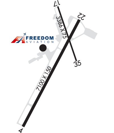
RY 17/35 PPR FOR ACFT OVER 12500 LBS.
TWY G CLSD TO AIR CARRIER AND ACFT OVER 12500 LBS.
ALL SURFACES WORK IN PROGRESS MOWING/MAINTENANCE.
EXTSV FLT TRNG ON AND INVOF ARPT.
FOR CD WHEN ATCT CLSD CTC ROANOKE APCH AT 540-563-1307.
RWY 17/35 CLSD TO AIR CARRIER ACFT
RWY 17/3 5 RY 17/35 300 FT OVERRUN EACH END.
Airport Communications & Frequencies:
ATIS Frequencies:   Hours(local) of Operation: CONTINUOUS
119.8
LYNCHBURG Tower Frequencies:   Hours(local) of operation: 0630-2230   
127.65
257.8
LYNCHBURG Ground Frequencies:
121.9
Emergency Frequencies:
121.5
243.0
CTAF Frequency:
127.650
Unicom Frequency:
122.950
ROANOKE Primary Approach Frequencies:  
125.475 EAST OF LYH VORTAC
135.0 WEST OF LYH VORTAC
254.325
ROANOKE Primary Departure Frequencies:  
125.475 EAST OF LYH VORTAC
135.0 WEST OF LYH VORTAC
254.325
Runway Identifications
Runway Identification: 04/22
Length: 7100 ft
Width: 150 ft
Surface: ASPHALT-GOOD CONDITION
Edge lights: High Intensity

Treatment: GROOVED
Weight: PCN 29 /F/A/X/T

 Runway: 04   Runway: 22
Mag heading: 36°Mag heading: 216°
Rwy Slope: .64% UpRwy Slope: -.64% Down
Approach: ILSApproach:
Pattern: Left TrafficPattern: Left Traffic
Markings: PRECISION INSTRUMENTMarkings: NONPRECISION INSTRUMENT
Marking Condition: GOODMarking Condition: GOOD
Arresting Dev: Arresting Dev:
Lat & Long: N3718.9  W07912.5Lat. & Long.: N3719.9  W07911.8
Elev: 892.8 ft. MSLElev: 938.0 ft. MSL
TCH: 55 ft. AGLTCH: 45 ft. AGL
Visual Glide Path: 3.00 degreesVisual Glide Path: 3.00 degrees
Displaced Threshold: NoDisplaced Threshold: No
Touchdown Zone: YESTouchdown Zone: YES
Touchdown Elev.: 904.8 feetTouchdown Elev.: 938.1 feet
Visual Glide Slope: 4-Light PAPI on LEFT side of RunwayVisual Glide Slope: 4-Light PAPI on LEFT side of Runway
RVR Equipment: TOUCHDOWNRVR Equipment: ROLLOUT
RVV Equipment: YESRVV Equipment: NO
Approach Lights: MALSR - 1,400 foot medium intensity approach lighting system with runway alignment indicator lightsApproach Lights:
REIL: NOREIL: YES
Centerline Lights: NOCenterline Lights: NO
Touchdown lights: NOTouchdown lights: NO
Runway Category: Precision Instrument RunwayRunway Category: Runway with a Non-precision Approach having visibility minimums greater than 3/4 mile
Declared Distances: TORA:7100' TODA:7100' ASDA:6800' LDA:6800'Declared Distances: TORA:7100' TODA:7100' ASDA:7100' LDA:7100'
Runway Identification: 17/35
Length: 3386 ft
Width: 75 ft
Surface: ASPHALT-GOOD CONDITION
Edge lights: Medium Intensity

Treatment: NONE

 Runway: 17   Runway: 35
Mag heading: 169°Mag heading: 349°
Rwy Slope: -.01% DownRwy Slope: .01% Up
Approach: Approach:
Pattern: Left TrafficPattern: Left Traffic
Markings: NONPRECISION INSTRUMENTMarkings: NONPRECISION INSTRUMENT
Marking Condition: GOODMarking Condition: GOOD
Arresting Dev: Arresting Dev:
Lat & Long: N3720.0  W07912.1Lat. & Long.: N3719.5  W07911.8
Elev: 921.5 ft. MSLElev: 921.2 ft. MSL
TCH: 16 ft. AGLTCH: 17 ft. AGL
Visual Glide Path: 4.00 degreesVisual Glide Path: 4.00 degrees
Displaced Threshold: NoDisplaced Threshold: No
Touchdown Zone: YESTouchdown Zone: YES
Touchdown Elev.: 932.7 feetTouchdown Elev.: 932.7 feet
Visual Glide Slope: 2-Light PAPI on LEFT side of RunwayVisual Glide Slope: 2-Light PAPI on LEFT side of Runway
RVR Equipment: RVR Equipment:
RVV Equipment: NORVV Equipment: NO
Approach Lights: Approach Lights:
REIL: YESREIL: YES
Centerline Lights: NOCenterline Lights: NO
Touchdown lights: NOTouchdown lights: NO
Runway Category: Runway with a Non-precision ApproachRunway Category: Runway with a Non-precision Approach
Declared Distances: TORA:3386' TODA:3386' ASDA:3386' LDA:3386'Declared Distances: TORA:3386' TODA:3386' ASDA:3386' LDA:3386'
C:56/P: