| |||||||||||||||||||||||||||||||||||||||||||||||||||||||||||||||||||||
| |||||||||||||||||||||||||||||||||||||||||||||||||||||||||||||||||||||
| |||||||||||||||||||||||||||||||||||||||||||||||||||||||||||||||||||||
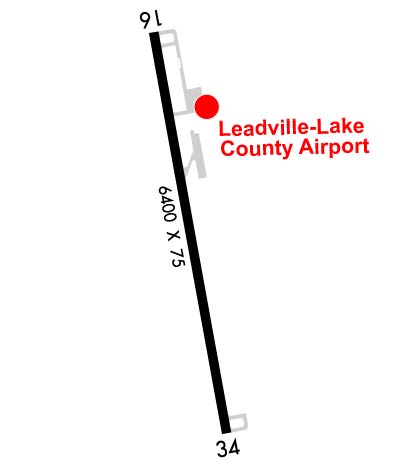
| Rwy | Rwy | |||||||
| 6400x75 | 6400' | 6400x75 | 6400' | |||||
| Runway ID | Single Wheel | Double Wheel | Double Tandem Wheel | Dual Double Wheel |
| 16/34 | 20,000 | 20,000 | N/A | N/A |
| H1 | N/A | N/A | N/A | N/A |
| These numbers are Advisory and are not limits. The Airport Manager should have more accurate Weight Limits | ||||
 Airport Diagram might not be current. | |
| Facility Name: | LAKE COUNTY |
| City Name: | LEADVILLE |
| County: | LAKE |
| State abbrev: | CO |
| State Name: | COLORADO |
| Ownership: | PUBLICLY OWNED |
| Use: | OPEN TO THE PUBLIC |
| Owner's Name: | COUNTY COMMISSIONER |
| Address: | LAKE COUNTY COURTHOUSE |
| LEADVILLE, CO 80461 | |
| Owner's Phone: | 719-486-4181 |
| Manager's Name: | BRETT COTTRELL |
| Address: | 915 CR 23, BOX 952 |
| LEADVILLE, CO 80461 | |
| Phone: | 719-486-0307 |
| FAA Region: | NORTHWEST MOUNTAIN |
| FAA Field Office: | DEN |
| Date | Sunrise | Sunset |
|---|---|---|
| 04/25/24 Thursday | 6:13 | 19:53 |
| 04/26/24 Friday | 6:12 | 19:54 |
| 04/27/24 Saturday | 6:11 | 19:55 |
| 04/28/24 Sunday | 6:10 | 19:56 |
| 04/29/24 Monday | 6:08 | 19:57 |
| 04/30/24 Tuesday | 6:07 | 19:58 |
| 05/01/24 Wednesday | 6:06 | 19:59 |
| 05/02/24 Thursday | 6:05 | 20:00 |
| 05/03/24 Friday | 6:03 | 20:01 |
| 05/04/24 Saturday | 6:02 | 20:02 |
| 05/05/24 Sunday | 6:01 | 20:03 |
| 05/06/24 Monday | 6:00 | 20:04 |
| 05/07/24 Tuesday | 5:59 | 20:05 |
| 05/08/24 Wednesday | 5:58 | 20:06 |
| Airport Attendance Schedule | MAY-SEP 7 Days A Week 0730-1630, OCT-APR 7 Days A Week 0800-1630; PPR FOR SVC AFT HRS CALL 719-427-0026. |
| Airport Status | OPERATIONAL (This Status can change at any time - please check NOTAMS) |
| Airport Lighting Schedule | ACTVT PAPI RWY 16 & 34; MIRL RWY 16/34 - CTAF. |
| Airport Storage Available | Tie Downs, Hanger |
| Extra Services Available | Charter |
| Wind Indicator | YES - (lighted) |
| Control Tower | NO |
| CTAF Frequency | 122.800 |
| Unicom Frequency | 122.800 |
| Rotating Beacon Color | WG |
| Segmented Circle | YES |
| Landing Fee | NO |
| Airport Inspected | STATE - performed by STATE AERONAUTICAL PERSONNEL |
| Inspection Date | 09/27/2018 |
| Type of Fuel Available | Grade 100LL, JET A (freeze point -40C) |
| Airframe Repair Service | None |
| Power Plant Repair Service | None |
| Latitude | N3913.2 |
| Longitude | W10619.0 (ESTIMATED) |
| Arpt Elevation | 9933ft (SURVEYED) |
| Magnetic Variation | 09E |
| 2 miles SW | of LEADVILLE |
| Traffic Pattern Altitude | |
| Sectional Chart | DENVER |
| Operations (Reported) | Yearly | Avg. Daily |
|---|---|---|
| General Aviation Transient | 1000 | 3 |
| General Aviation Local | 1800 | 5 |
| Air Taxi | 200 | 1 |
| Commerical | 0 | 0 |
| Commuter | 0 | 0 |
| Military | 2000 | 5 |
| Aircraft based on Field | |
|---|---|
| General Aviation Singles | 5 |
| General Aviation Multi | 0 |
| Jet Aircraft | 0 |
| General Aviation Helicopters | 0 |
| Military Aircraft | 0 |
| Gliders | 0 |
| Ultralights | 0 |
| FSS on field | NO |
| FSS tie-in | DENVER |
| FSS Phone | 1-800-WX-BRIEF |
| Who issues Notams | LXV |
| Notam D service at airport | YES |
| ARTCC Name | DENVER |
| Airport Certification | |
| Aircraft Rescue & Firefighting Index | None |
| Airport of Entry | No |
| Custom Landing Rights | No |
| Joint Civil/Military | No |
| Military Landing rights | YES |
| NATIONAL PLAN OF INTEGRATED AIRPORT SYSTEMS (NPIAS) |
| GRANT AGREEMENTS UNDER FAAP/ADAP/AIP |
| CONVEYANCE UNDER SCETION 16, FEDERAL AIRPORT ACT OF 1946 OR SECTION 23, AIRPORT AND AIRWAY DEVELOPMENT ACT OF 1970 |
| ASSURANCES PURSUANT TO TITLE VI, CIVIL RIGHTS ACT OF 1964 |
| OBSTRN LGTS ON BCN TWR. |
| FOR CD CTC DENVER ARTCC AT 303-651-4257. |
| ALL TWYS & NEW RAMP AREA MKD WITH BLUE & WHITE REFLECTORS. |
| TWY C AND OLD RAMP HAVE POTHOLES & LOOSE AGGREGATE. |
| RY H1 HAS 20-30 FT TREES 130 FT EAST OF PAD. |
| ALL PAVEMENT EDGES HAVE SOFT SHOULDERS. |
| RY 34 HA +50 FT POWER LINES 750 FT RIGHT OF THRESHOLD. |
Airport Communications & Frequencies:
| |||||||||
| Runway: 16 | Runway: 34 | ||
| Mag heading: | 161° | Mag heading: | 341° |
| Rwy Slope: | -.10% Down | Rwy Slope: | .10% Up |
| Approach: | Approach: | ||
| Pattern: | Right Traffic | Pattern: | Left Traffic |
| Markings: | NONPRECISION INSTRUMENT | Markings: | NONPRECISION INSTRUMENT |
| Marking Condition: | GOOD | Marking Condition: | GOOD |
| Arresting Dev: | Arresting Dev: | ||
| Lat & Long: | N3913.7 W10619.1 | Lat. & Long.: | N3912.6 W10618.9 |
| Elev: | 9930.7 ft. MSL | Elev: | 9924.6 ft. MSL |
| TCH: | 45 ft. AGL | TCH: | 45 ft. AGL |
| Visual Glide Path: | 3.00 degrees | Visual Glide Path: | 3.00 degrees |
| Displaced Threshold: | No | Displaced Threshold: | No |
| Touchdown Zone: | YES | Touchdown Zone: | YES |
| Touchdown Elev.: | 9933.5 feet | Touchdown Elev.: | 9930.8 feet |
| Visual Glide Slope: | 2-Light PAPI on LEFT side of Runway | Visual Glide Slope: | 2-Light PAPI on LEFT side of Runway |
| RVR Equipment: | RVR Equipment: | ||
| RVV Equipment: | NO | RVV Equipment: | NO |
| Approach Lights: | Approach Lights: | ||
| REIL: | NO | REIL: | NO |
| Centerline Lights: | NO | Centerline Lights: | NO |
| Touchdown lights: | NO | Touchdown lights: | NO |
| Runway Category: | Runway with a Non-precision Approach having visibility minimums greater than 3/4 mile | Runway Category: | Runway with a Visual Approach |
| Declared Distances: | Declared Distances: |