Click here for more info on on SMS!

KLXT

LEE'S SUMMIT MUNI
LEE'S SUMMIT
MO
Time Zone: Central
Lat: N 3857.5
Long: W 09422.3
Elev: 1004
Var: -02
Longest Runway: 5501
Clr Del: 118.45
AWOS: 124.17
CTAF: 122.8

FBO & Flight Services info for KLXT

FBOs: Update your Fuel Prices

  click here  
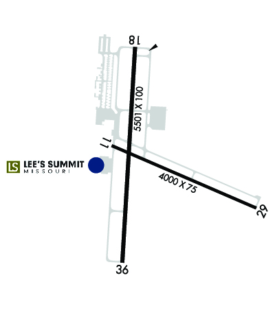
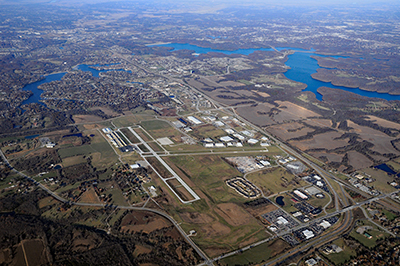
The Lee's Summit Airport now offers a 5,501 ft. grooved runway along with a full service FBO that now serves the Greater Kansas City area. The Lee's Summit Airport is only minutes away from locationsSouth of Downtown including Arrowhead Stadium, Kaufman Stadium, and the Plaza shopping area. Additionally, Lee's Summit is minutes away from locations in Independence and Overland Park.
Ph: 816-969-1186 Fax: 816-969-1184 Freq: 122.8WebsiteE-Mail
                   
Service
Jet
100LL
SAF
MoGas
Fuel Avail: 7 DAYS/WEEK 6 a.m. - 8 p.m. After-Hours service available upon request ($175).
Full6.266.61  5.24Last Update: 04/16/2024 08:02
PRICES GUARANTEED by FBO. *
*CAA Preferred FBO.
Self  5.75  4.49
Misc. Info: ****CAA Preferred FBO**** CHIEFS GAMES WERE OPEN UNTIL THE LAST PLANE LEAVESAddress: 2751 NE DOUGLAS,   LEE'S SUMMIT, MO 64064

ASOSPh: 816-347-9807
-
Freq: 124.17  
If you are an FBO, call 1-203-262-1700 to update your info or email: FltPlan.Advertising@garmin.com
Advertise your FBO on FltPlan.com

Runway & Approach Info for KLXT
Rwy
Length
Land Dist**
Approach*
  Rwy
Length
Land Dist**
Approach*
11
4000x75  4000'          
 
  
29
  4000x75  4000'          
 
18
5501x100  5501'          
 
  
36
  5501x100  5501'          
 
 * only ILS, LOC, LDA, and SDF approaches to a specific runway are shown
** For any Declared Landing Distance Available, please see A/FD or Approach plates
Runway Weight Capability (lbs.) Help
Runway IDSingle WheelDouble WheelDouble Tandem WheelDual Double Wheel
11/2930,00030,000N/AN/A
18/3640,00060,000N/AN/A
These numbers are Advisory and are not limits.   The Airport Manager should have more accurate Weight Limits
Approach Charts
Approaches    
Current Weather/Notams
Customs Information Send updates to Support@FltPlan.com
Customs Not Available
Database effective 04/18/2024
Airport Diagram of KLXT
Airport Diagram might not be current.

Facility Name: LEE'S SUMMIT MUNI
City Name: LEE'S SUMMIT
County: JACKSON
State abbrev: MO
State Name: MISSOURI
   
Ownership: PUBLICLY OWNED
Use: OPEN TO THE PUBLIC
Owner's Name: CITY OF LEE'S SUMMIT
Address: 220 SE GREEN, P.O. BOX 1600
 LEES SUMMIT, MO 64063
Owner's Phone: 816-969-1000
  
Manager's Name: JOEL ARRINGTON
Address: 2751 NE DOUGLAS RD
 LEES SUMMIT, MO 64064
Phone: 816-969-1186
   
FAA Region: CENTRAL
FAA Field Office: NONE


Sunrise / Sunset times for LEE'S SUMMIT MUNI

DateSunriseSunset
04/18/24 Thursday6:3619:58
04/19/24 Friday6:3419:59
04/20/24 Saturday6:3320:00
04/21/24 Sunday6:3120:01
04/22/24 Monday6:3020:02
04/23/24 Tuesday6:2920:03
04/24/24 Wednesday6:2720:04
04/25/24 Thursday6:2620:05
04/26/24 Friday6:2520:06
04/27/24 Saturday6:2420:07
04/28/24 Sunday6:2220:08
04/29/24 Monday6:2120:09
04/30/24 Tuesday6:2020:10
05/01/24 Wednesday6:1920:11

Airport Facilities

Airport Attendance Schedule7 Days A Week 0600-2000
Airport Status OPERATIONAL (This Status can change at any time - please check NOTAMS)
Airport Lighting ScheduleACTVT REIL RWY 18 & 36, 11 & 29; MIRL RWY 11 & 29, 18 & 36 - CTAF. PAPI RWY 11 & 29, 18 & 36 OPR CONSLY.
Airport Storage AvailableTie Downs, Hanger
Extra Services AvailableFlight Instruction, Aircraft Rental, Annual Surveying
Wind IndicatorYES - (lighted)
Control TowerNO
CTAF Frequency122.800
Unicom Frequency122.800
Rotating Beacon ColorWG
Segmented CircleYES
Landing FeeNO

Airport Inspection Data

Airport InspectedSTATE - performed by STATE AERONAUTICAL PERSONNEL
Inspection Date08/18/2021

Airport Services

Type of Fuel AvailableGrade 100LL, JET A (freeze point -40C)MOGAS; -1024 HR SELF SERVICE FUEL 100LL & MOGAS. MOBILE FUEL JET A AND 100LL. AFTER HRS FUEL CALL 816-969-1186. CALL OUT FEE.
Airframe Repair ServiceMAJOR
Power Plant Repair ServiceMAJOR

Geographic Data

LatitudeN3857.5
LongitudeW09422.3 (ESTIMATED)
Arpt Elevation1004ft (SURVEYED)
Magnetic Variation02E
3 miles Nof LEE'S SUMMIT
Traffic Pattern Altitude1000; TPA ACFT UNDER 6,000 LBS 1000 FT AGL, ACFT OVER 6,000 LBS 1,500 FT AGL.
Sectional ChartKANSAS CITY

Aircraft Data

Operations (Reported)YearlyAvg. Daily
General Aviation Transient 1515042
General Aviation Local 3485095
Air Taxi 17505
Commerical 00
Commuter 00
Military 7502
Aircraft based on Field
General Aviation Singles 115
General Aviation Multi 9
Jet Aircraft 6
General Aviation Helicopters 2
Military Aircraft 0
Gliders 0
Ultralights 0

FAA Services

FSS on field NO
FSS tie-in COLUMBIA
FSS Phone 1-800-WX-BRIEF
Who issues Notams LXT
Notam D service at airport YES
ARTCC Name KANSAS CITY

Federal Status

Airport Certification
Aircraft Rescue & Firefighting IndexNone
Airport of EntryNo
Custom Landing RightsNo
Joint Civil/MilitaryNo
Military Landing rightsYES

Federal Agreements

NATIONAL PLAN OF INTEGRATED AIRPORT SYSTEMS (NPIAS)
GRANT AGREEMENTS UNDER FAAP/ADAP/AIP
ASSURANCES PURSUANT TO TITLE VI, CIVIL RIGHTS ACT OF 1964

Remarks

NO RIGHT TURNS UNDER 2500 FT MSL OR WITHIN 3 MI OF ARPT WHEN DEPARTING ON RWY 29.
FOR CD CTC KANSAS CITY APCH 118.45 OR 816-329-2710.
NO LEFT TURNS WITHIN 1/2 MI OF END OF RWY WHEN DEPARTING ON RWY 18.
NO LEFT TURNS UNDER 2500 FT MSL OR WITHIN 3 MI OF THE ARPT DEPARTING ON RWY 36.
WILDLIFE ON & INVOF ARPT.
WHEN WINDS ARE LESS THAN 5 KNOTS USE RWY 18.
AER 18,36 & 29 ARE NOT MUTUALLY VSB DUE TO TRRN.
ARPT TRML BLDG OPEN 24 HRS.
RWY 18/36 GRAD 0.16%, RWY 11/29 GRAD 0.24%
Airport Communications & Frequencies:
Clearance Delivery Frequencies:
118.45
CTAF Frequency:
122.800
Unicom Frequency:
122.800
KANSAS CITY Primary Approach Frequencies:  
118.4
307.35
KANSAS CITY Primary Departure Frequencies:  
118.4
307.35
Runway Identifications
Runway Identification: 11/29
Length: 4000 ft
Width: 75 ft
Surface: CONCRETE-GOOD CONDITION
Edge lights: Medium Intensity

Treatment: NONE

 Runway: 11   Runway: 29
Mag heading: 111°Mag heading: 291°
Rwy Slope: .24% UpRwy Slope: -.24% Down
Approach: Approach:
Pattern: Right TrafficPattern: Left Traffic
Markings: NONPRECISION INSTRUMENTMarkings: NONPRECISION INSTRUMENT
Marking Condition: GOODMarking Condition: GOOD
Arresting Dev: Arresting Dev:
Lat & Long: N3857.6  W09422.5Lat. & Long.: N3857.4  W09421.8
Elev: 991.9 ft. MSLElev: 1001.6 ft. MSL
TCH: 45 ft. AGLTCH: 40 ft. AGL
Visual Glide Path: 3.00 degreesVisual Glide Path: 3.00 degrees
Displaced Threshold: NoDisplaced Threshold: No
Touchdown Zone: YESTouchdown Zone: YES
Touchdown Elev.: 1004.1 feetTouchdown Elev.: 1004.1 feet
Visual Glide Slope: 4-Light PAPI on LEFT side of RunwayVisual Glide Slope: 4-Light PAPI on RIGHT side of Runway
RVR Equipment: RVR Equipment:
RVV Equipment: NORVV Equipment: NO
Approach Lights: Approach Lights:
REIL: YESREIL: YES
Centerline Lights: NOCenterline Lights: NO
Touchdown lights: NOTouchdown lights: NO
Runway Category: Runway with a Non-precision Approach having visibility minimums greater than 3/4 mileRunway Category: Runway with a Non-precision Approach having visibility minimums greater than 3/4 mile
Declared Distances: Declared Distances:
Runway Identification: 18/36
Length: 5501 ft
Width: 100 ft
Surface: CONCRETE
Edge lights: Medium Intensity

Treatment: GROOVED
Weight: PCN 22 /R/C/W/T

 Runway: 18   Runway: 36
Mag heading: 181°Mag heading:
Rwy Slope: -.16% DownRwy Slope: .16% Up
Approach: Approach:
Pattern: Left TrafficPattern: Right Traffic
Markings: NONPRECISION INSTRUMENTMarkings: NONPRECISION INSTRUMENT
Marking Condition: GOODMarking Condition: GOOD
Arresting Dev: Arresting Dev:
Lat & Long: N3858.0  W09422.4Lat. & Long.: N3857.1  W09422.5
Elev: 995.0 ft. MSLElev: 986.0 ft. MSL
TCH: 44 ft. AGLTCH: 45 ft. AGL
Visual Glide Path: 3.00 degreesVisual Glide Path: 3.00 degrees
Displaced Threshold: NoDisplaced Threshold: No
Touchdown Zone: YESTouchdown Zone: YES
Touchdown Elev.: 998.3 feetTouchdown Elev.: 996.7 feet
Visual Glide Slope: 4-Light PAPI on LEFT side of RunwayVisual Glide Slope: 4-Light PAPI on LEFT side of Runway
RVR Equipment: RVR Equipment:
RVV Equipment: NORVV Equipment: NO
Approach Lights: Approach Lights:
REIL: YESREIL: YES
Centerline Lights: NOCenterline Lights: NO
Touchdown lights: NOTouchdown lights: NO
Runway Category: DRunway Category: Runway with a Non-precision Approach having visibility minimums greater than 3/4 mile
Declared Distances: Declared Distances:
C:30/P: