Current Weather/Notams (Metars, TAFs, Notams, NWS Forecast, PIREPS, and nearby weather)
Customs Information Send updates to Support@FltPlan.com
Customs Not Available
Database effective 04/18/2024
Airport Diagram might not be current.
|
| Facility Name: | LAWRENCEVILLE-VINCENNES INTL |
| City Name: | LAWRENCEVILLE |
| County: | LAWRENCE |
| State abbrev: | IL |
| State Name: | ILLINOIS |
| | |
| Ownership: | PUBLICLY OWNED |
| Use: | OPEN TO THE PUBLIC |
| Owner's Name: | BI-STATE AUTHORITY; JOINT OWNED - CITY OF VINCENNES IN & LAWRENCEVILLE IL. |
| Address: | 13608 HANGAR RD |
| | LAWRENCEVILLE, IL 62439 |
| Owner's Phone: | 618-943-5733 |
| | |
| Manager's Name: | KURTIS SCHWARTZ |
| Address: | 13608 HANGAR RD |
| | LAWRENCEVILLE, IL 62439 |
| Phone: | 618-943-5733; 812-881-7042. |
| | |
| FAA Region: | GREAT LAKES |
| FAA Field Office: | CHI |
Runway Identifications
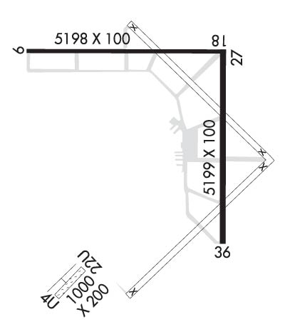
Runway Identification: 04U/22ULength: 1000 ft
Width: 200 ft
Surface: GRASS-FAIR CONDITION
Edge lights: Treatment: NONE
| | Runway: 04U | | Runway: 22U |
| Mag heading: | N/A | Mag heading: | N/A |
| Approach: | | Approach: | |
| Pattern: | Left Traffic | Pattern: | Right Traffic |
| Markings: | | Markings: | |
| Marking Condition: | | Marking Condition: | |
| Arresting Dev: | | Arresting Dev: | |
| Lat & Long: | | Lat. & Long.: | |
| Elev: | N/A | Elev: | N/A |
| TCH: | | TCH: | |
| Visual Glide Path: | | Visual Glide Path: | |
| Displaced Threshold: | No | Displaced Threshold: | No |
| Touchdown Zone: | NO | Touchdown Zone: | NO |
| Touchdown Elev.: | | Touchdown Elev.: | |
| Visual Glide Slope: | | Visual Glide Slope: | |
| RVR Equipment: | | RVR Equipment: | |
| RVV Equipment: | NO | RVV Equipment: | NO |
| Approach Lights: | | Approach Lights: | |
| REIL: | NO | REIL: | NO |
| Centerline Lights: | NO | Centerline Lights: | NO |
| Touchdown lights: | NO | Touchdown lights: | NO |
| Runway Category: | Runway with a Visual Approach | Runway Category: | Runway with a Visual Approach |
| Declared Distances: | | Declared Distances: | |
Runway Identification: 09/27Length: 5198 ft
Width: 100 ft
Surface: ASPHALT-GOOD CONDITION
Edge lights: Medium IntensityTreatment: NONE
| | Runway: 09 | | Runway: 27 |
| Mag heading: | 90° | Mag heading: | 270° |
| Rwy Slope: | .08% Up | Rwy Slope: | -.08% Down |
| Approach: | | Approach: | |
| Pattern: | Left Traffic | Pattern: | Left Traffic |
| Markings: | NONPRECISION INSTRUMENT | Markings: | NONPRECISION INSTRUMENT |
| Marking Condition: | GOOD | Marking Condition: | GOOD |
| Arresting Dev: | | Arresting Dev: | |
| Lat & Long: | N3846.1 W08737.1 | Lat. & Long.: | N3846.1 W08736.1 |
| Elev: | 425.6 ft. MSL | Elev: | 429.5 ft. MSL |
| TCH: | 26 ft. AGL | TCH: | 26 ft. AGL |
| Visual Glide Path: | 3.00 degrees | Visual Glide Path: | 3.00 degrees |
| Displaced Threshold: | No | Displaced Threshold: | No |
| Touchdown Zone: | YES | Touchdown Zone: | YES |
| Touchdown Elev.: | 428.0 feet | Touchdown Elev.: | 429.8 feet |
| Visual Glide Slope: | PULSATING/STEADY BURNING VASI ON LEFT SIDE OF RUNWAY; PVASI UNUSBL BYD 8 DEGREES LEFT OF CNTRLN & BYD 6 DEGREES RIGHT OF CNTRLN. | Visual Glide Slope: | 4-Light PAPI on LEFT side of Runway |
| RVR Equipment: | | RVR Equipment: | |
| RVV Equipment: | NO | RVV Equipment: | NO |
| Approach Lights: | | Approach Lights: | ODALS - omnidirectional approach lighting system |
| REIL: | YES | REIL: | YES |
| Centerline Lights: | NO | Centerline Lights: | NO |
| Touchdown lights: | NO | Touchdown lights: | NO |
| Runway Category: | D | Runway Category: | D |
| Declared Distances: | | Declared Distances: | |
Runway Identification: 18/36Length: 5199 ft
Width: 100 ft
Surface: ASPHALT-GOOD CONDITION
Edge lights: Medium IntensityTreatment: NONE
| | Runway: 18 | | Runway: 36 |
| Mag heading: | 180° | Mag heading: | 360° |
| Rwy Slope: | -.09% Down | Rwy Slope: | .09% Up |
| Approach: | | Approach: | |
| Pattern: | Left Traffic | Pattern: | Left Traffic |
| Markings: | NONPRECISION INSTRUMENT | Markings: | NONPRECISION INSTRUMENT |
| Marking Condition: | FAIR | Marking Condition: | FAIR |
| Arresting Dev: | | Arresting Dev: | |
| Lat & Long: | N3846.1 W08736.1 | Lat. & Long.: | N3845.2 W08736.1 |
| Elev: | 429.4 ft. MSL | Elev: | 424.9 ft. MSL |
| TCH: | 25 ft. AGL | TCH: | 41 ft. AGL |
| Visual Glide Path: | 3.00 degrees | Visual Glide Path: | 3.00 degrees |
| Displaced Threshold: | No | Displaced Threshold: | No |
| Touchdown Zone: | YES | Touchdown Zone: | YES |
| Touchdown Elev.: | 429.7 feet | Touchdown Elev.: | 428.0 feet |
| Visual Glide Slope: | PULSATING/STEADY BURNING VASI ON LEFT SIDE OF RUNWAY; PVASI UNUSBL BYD 8 DEGREES LEFT OF CNTRLN & BYD 6 DEGREES RIGHT OF CNTRLN. | Visual Glide Slope: | 4-Light PAPI on LEFT side of Runway |
| RVR Equipment: | | RVR Equipment: | |
| RVV Equipment: | NO | RVV Equipment: | NO |
| Approach Lights: | | Approach Lights: | |
| REIL: | YES | REIL: | YES |
| Centerline Lights: | NO | Centerline Lights: | NO |
| Touchdown lights: | NO | Touchdown lights: | NO |
| Runway Category: | D | Runway Category: | Runway with a Non-precision Approach having visibility minimums greater than 3/4 mile |
| Declared Distances: | | Declared Distances: | |