Current Weather/Notams (Metars, TAFs, Notams, NWS Forecast, PIREPS, and nearby weather)
Customs Information Send updates to Support@FltPlan.com
Customs Not Available
Database effective 04/18/2024
Airport Diagram might not be current.
|
| Facility Name: | SOUTH HAVEN AREA RGNL |
| City Name: | SOUTH HAVEN |
| County: | VAN BUREN |
| State abbrev: | MI |
| State Name: | MICHIGAN |
| | |
| Ownership: | PUBLICLY OWNED |
| Use: | OPEN TO THE PUBLIC |
| Owner's Name: | SO HAVEN AREA RGNL ARPT AUTH |
| Address: | 73020 COUNTY ROAD 380 |
| | SOUTH HAVEN, MI 49090-9441 |
| Owner's Phone: | 269-637-7343 |
| | |
| Manager's Name: | JOHN CARLSON |
| Address: | 73020 COUNTY ROAD 380 |
| | SOUTH HAVEN, MI 49090-9441 |
| Phone: | 269-637-7343; CELL 269-209-4832. |
| | |
| FAA Region: | GREAT LAKES |
| FAA Field Office: | DET |
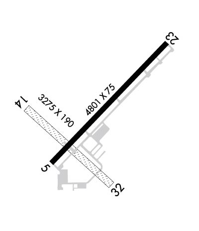
Runway Identifications
Runway Identification: 05/23Length: 4800 ft
Width: 75 ft
Surface: ASPHALT-GOOD CONDITION
Edge lights: Medium IntensityTreatment: NONE
| | Runway: 05 | | Runway: 23 |
| Mag heading: | 47° | Mag heading: | 227° |
| Rwy Slope: | .28% Up | Rwy Slope: | -.28% Down |
| Approach: | | Approach: | |
| Pattern: | Left Traffic | Pattern: | Left Traffic |
| Markings: | NONPRECISION INSTRUMENT | Markings: | NONPRECISION INSTRUMENT |
| Marking Condition: | GOOD | Marking Condition: | GOOD |
| Arresting Dev: | | Arresting Dev: | |
| Lat & Long: | N4220.9 W08615.6 | Lat. & Long.: | N4221.4 W08614.9 |
| Elev: | 651.8 ft. MSL | Elev: | 665.4 ft. MSL |
| TCH: | 33 ft. AGL | TCH: | 33 ft. AGL |
| Visual Glide Path: | 3.50 degrees | Visual Glide Path: | 3.50 degrees |
| Displaced Threshold: | No | Displaced Threshold: | No |
| Touchdown Zone: | YES | Touchdown Zone: | YES |
| Touchdown Elev.: | 658.9 feet | Touchdown Elev.: | 665.5 feet |
| Visual Glide Slope: | 4-Light PAPI on LEFT side of Runway | Visual Glide Slope: | 4-Light PAPI on LEFT side of Runway |
| RVR Equipment: | | RVR Equipment: | |
| RVV Equipment: | NO | RVV Equipment: | NO |
| Approach Lights: | | Approach Lights: | |
| REIL: | YES | REIL: | YES |
| Centerline Lights: | NO | Centerline Lights: | NO |
| Touchdown lights: | NO | Touchdown lights: | NO |
| Runway Category: | Runway with a Non-precision Approach | Runway Category: | Runway with a Non-precision Approach |
| Declared Distances: | | Declared Distances: | |
| Obstructions: | TREE | Obstructions: | TREES |
| Marked: | NOT Marked/Lighted | Marked: | NOT Marked/Lighted |
| Clearance slope: | 19:1 | Clearance slope: | 13:1 |
| Obstruction height: | 60 feet AGL | Obstruction height: | 22 feet AGL |
| Dist. from runway: | 1395 feet | Dist. from runway: | 505 feet |
| Centerline offset: | 280 left of centerline | Centerline offset: | 280 feet right of centerline |
| Comments: | | Comments: | |
Runway Identification: 14/32Length: 3260 ft
Width: 190 ft
Surface: GRASS-FAIR CONDITION
Edge lights: Treatment: NONE
| | Runway: 14 | | Runway: 32 |
| Mag heading: | 136° | Mag heading: | 316° |
| Rwy Slope: | .46% Up | Rwy Slope: | -.46% Down |
| Approach: | | Approach: | |
| Pattern: | Left Traffic | Pattern: | Left Traffic |
| Markings: | | Markings: | |
| Marking Condition: | DTHR MKD WITH 3 FT YELLOW CONES, 3 EACH SIDE. | Marking Condition: | DTHR MKD WITH 3 FT YELLOW CONES, 3 EACH SIDE. |
| Arresting Dev: | | Arresting Dev: | |
| Lat & Long: | N4221.1 W08615.8 | Lat. & Long.: | N4220.8 W08615.2 |
| Elev: | 648.5 ft. MSL | Elev: | 663.5 ft. MSL |
| TCH: | | TCH: | |
| Visual Glide Path: | | Visual Glide Path: | |
| Displaced Threshold: | 956 feet | Displaced Threshold: | 1229 feet |
| Touchdown Zone: | YES | Touchdown Zone: | YES |
| Touchdown Elev.: | 663.5 feet | Touchdown Elev.: | 657.0 feet |
| Visual Glide Slope: | | Visual Glide Slope: | |
| RVR Equipment: | | RVR Equipment: | |
| RVV Equipment: | NO | RVV Equipment: | NO |
| Approach Lights: | | Approach Lights: | |
| REIL: | NO | REIL: | NO |
| Centerline Lights: | NO | Centerline Lights: | NO |
| Touchdown lights: | NO | Touchdown lights: | NO |
| Runway Category: | Runway with a Visual Approach | Runway Category: | Runway with a Visual Approach |
| Declared Distances: | | Declared Distances: | |
| Obstructions: | TREES | Obstructions: | TREE |
| Marked: | NOT Marked/Lighted | Marked: | NOT Marked/Lighted |
| Clearance slope: | APCH RATIO 12:1 TO DTHR OVR 78 FT TREES, 966 FT DIST, 110 FT L. | Clearance slope: | 4:1 |
| Obstruction height: | 78 feet AGL | Obstruction height: | 50 feet AGL |
| Dist. from runway: | 10 feet | Dist. from runway: | 235 feet |
| Centerline offset: | 110 left of centerline | Centerline offset: | 148 feet left of centerline |
| Comments: | | Comments: | |

