Current Weather/Notams (Metars, TAFs, Notams, NWS Forecast, PIREPS, and nearby weather)
Customs Information Send updates to Support@FltPlan.com
Customs Not Available
Database effective 04/18/2024
Airport Diagram might not be current.
|
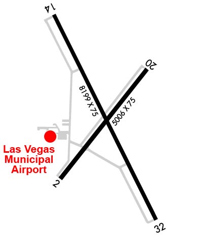
| Facility Name: | LAS VEGAS MUNI |
| City Name: | LAS VEGAS |
| County: | SAN MIGUEL |
| State abbrev: | NM |
| State Name: | NEW MEXICO |
| | |
| Ownership: | PUBLICLY OWNED |
| Use: | OPEN TO THE PUBLIC |
| Owner's Name: | CITY OF LAS VEGAS |
| Address: | 1700 NORTH GRAND |
| | LAS VEGAS, NM 87701 |
| Owner's Phone: | 505-454-1401 |
| | |
| Manager's Name: | JOHN ARAGON |
| Address: | 910 AIRPORT ROAD |
| | LAS VEGAS, NM 87701 |
| Phone: | 505-454-0881 |
| | |
| FAA Region: | SOUTHWEST |
| FAA Field Office: | LNM |
Runway Identifications
Runway Identification: 02/20Length: 5006 ft
Width: 75 ft
Surface: ASPHALT-GOOD CONDITION
Edge lights: Medium IntensityTreatment: NONE
Weight: PCN 8 /F/D/X/T
| | Runway: 02 | | Runway: 20 |
| Mag heading: | 22° | Mag heading: | 202° |
| Rwy Slope: | -.11% Down | Rwy Slope: | .11% Up |
| Approach: | | Approach: | |
| Pattern: | Left Traffic | Pattern: | Left Traffic |
| Markings: | NONPRECISION INSTRUMENT | Markings: | NONPRECISION INSTRUMENT |
| Marking Condition: | GOOD | Marking Condition: | GOOD |
| Arresting Dev: | | Arresting Dev: | |
| Lat & Long: | N3538.9 W10508.8 | Lat. & Long.: | N3539.6 W10508.3 |
| Elev: | 6866.0 ft. MSL | Elev: | 6860.5 ft. MSL |
| TCH: | 40 ft. AGL | TCH: | 40 ft. AGL |
| Visual Glide Path: | 3.00 degrees | Visual Glide Path: | 3.00 degrees |
| Displaced Threshold: | No | Displaced Threshold: | No |
| Touchdown Zone: | YES | Touchdown Zone: | YES |
| Touchdown Elev.: | 6869.7 feet | Touchdown Elev.: | 6866.9 feet |
| Visual Glide Slope: | 2-Light PAPI on LEFT side of Runway | Visual Glide Slope: | 2-Light PAPI on LEFT side of Runway |
| RVR Equipment: | | RVR Equipment: | |
| RVV Equipment: | NO | RVV Equipment: | NO |
| Approach Lights: | ODALS - omnidirectional approach lighting system; NSTD ODALS OUT OF SERVICE INDEFINITELY. | Approach Lights: | ODALS - omnidirectional approach lighting system; NSTD ODALS - OUT OF SERVICE INDEFINITELY. |
| REIL: | NO | REIL: | NO |
| Centerline Lights: | NO | Centerline Lights: | NO |
| Touchdown lights: | NO | Touchdown lights: | NO |
| Runway Category: | Runway with a Non-precision Approach | Runway Category: | Runway with a Non-precision Approach |
| Declared Distances: | | Declared Distances: | |
Runway Identification: 14/32Length: 8199 ft
Width: 75 ft
Surface: ASPHALT-GOOD CONDITION
Edge lights: Medium IntensityTreatment: NONE
Weight: PCN 7 /F/D/X/T
| | Runway: 14 | | Runway: 32 |
| Mag heading: | 139° | Mag heading: | 319° |
| Rwy Slope: | .45% Up | Rwy Slope: | -.45% Down |
| Approach: | | Approach: | |
| Pattern: | Left Traffic | Pattern: | Left Traffic |
| Markings: | NONPRECISION INSTRUMENT | Markings: | NONPRECISION INSTRUMENT |
| Marking Condition: | GOOD | Marking Condition: | GOOD |
| Arresting Dev: | | Arresting Dev: | |
| Lat & Long: | N3539.9 W10508.9 | Lat. & Long.: | N3538.7 W10508.1 |
| Elev: | 6839.9 ft. MSL | Elev: | 6877.2 ft. MSL |
| TCH: | 41 ft. AGL | TCH: | 36 ft. AGL |
| Visual Glide Path: | 3.00 degrees | Visual Glide Path: | 3.00 degrees |
| Displaced Threshold: | No | Displaced Threshold: | No |
| Touchdown Zone: | YES | Touchdown Zone: | YES |
| Touchdown Elev.: | 6855.0 feet | Touchdown Elev.: | 6877.2 feet |
| Visual Glide Slope: | 2-Light PAPI on LEFT side of Runway | Visual Glide Slope: | 2-Light PAPI on LEFT side of Runway |
| RVR Equipment: | | RVR Equipment: | |
| RVV Equipment: | NO | RVV Equipment: | NO |
| Approach Lights: | | Approach Lights: | |
| REIL: | NO | REIL: | NO |
| Centerline Lights: | NO | Centerline Lights: | NO |
| Touchdown lights: | NO | Touchdown lights: | NO |
| Runway Category: | Runway with a Visual Approach | Runway Category: | Runway with a Non-precision Approach |
| Declared Distances: | | Declared Distances: | |