
| ||||||||||||||||||||||||||||||||||||||||||||
| ||||||||||||||||||||||||||||||||||||||||||||
| ||||||||||||||||||||||||||||||||||||||||||||
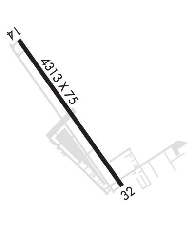
| Rwy | Rwy | |||||||
| 4313x75 | 4313' | 4313x75 | 4313' | |||||
| Runway ID | Single Wheel | Double Wheel | Double Tandem Wheel | Dual Double Wheel |
| 14/32 | 30,000 | N/A | N/A | N/A |
| These numbers are Advisory and are not limits. The Airport Manager should have more accurate Weight Limits | ||||
 Airport Diagram might not be current. | |
| Facility Name: | PEARLAND RGNL |
| City Name: | HOUSTON |
| County: | BRAZORIA |
| State abbrev: | TX |
| State Name: | TEXAS |
| Ownership: | PRIVATELY OWNED |
| Use: | OPEN TO THE PUBLIC |
| Owner's Name: | CLOVER ACQUISITION CORP. |
| Address: | 17622 AIRFIELD LN |
| PEARLAND, TX 77581 | |
| Owner's Phone: | 281-482-7551 |
| Manager's Name: | JASON PANOS |
| Address: | 17622 AIRFIELD LN |
| PEARLAND, TX 77581 | |
| Phone: | 281-482-7551; EXT 3. |
| FAA Region: | SOUTHWEST |
| FAA Field Office: | TEX |
| Date | Sunrise | Sunset |
|---|---|---|
| 04/18/24 Thursday | 6:51 | 19:50 |
| 04/19/24 Friday | 6:50 | 19:51 |
| 04/20/24 Saturday | 6:49 | 19:51 |
| 04/21/24 Sunday | 6:48 | 19:52 |
| 04/22/24 Monday | 6:47 | 19:53 |
| 04/23/24 Tuesday | 6:46 | 19:53 |
| 04/24/24 Wednesday | 6:45 | 19:54 |
| 04/25/24 Thursday | 6:44 | 19:54 |
| 04/26/24 Friday | 6:43 | 19:55 |
| 04/27/24 Saturday | 6:42 | 19:56 |
| 04/28/24 Sunday | 6:41 | 19:56 |
| 04/29/24 Monday | 6:40 | 19:57 |
| 04/30/24 Tuesday | 6:39 | 19:58 |
| 05/01/24 Wednesday | 6:38 | 19:58 |
| Airport Attendance Schedule | 7 Days A Week 0800-1900 |
| Airport Status | OPERATIONAL (This Status can change at any time - please check NOTAMS) |
| Airport Lighting Schedule | MIRL RWY 14/32 SS-SR PRESET LOW INTST; INCR INTST & ACTVT - CTAF. |
| Airport Storage Available | Tie Downs, Hanger |
| Extra Services Available | Avionics, Charter, Flight Instruction, Aircraft Rental |
| Wind Indicator | YES - (lighted) |
| Control Tower | NO |
| CTAF Frequency | 122.725 |
| Unicom Frequency | 122.725 |
| Rotating Beacon Color | WG |
| Segmented Circle | YES |
| Landing Fee | NO |
| Airport Inspected | STATE - performed by PRIVATE CONTRACT PERSONNEL |
| Inspection Date | 04/06/2023 |
| Type of Fuel Available | Grade 100LL, JET A (freeze point -40C) |
| Airframe Repair Service | MAJOR |
| Power Plant Repair Service | MAJOR |
| Latitude | N2931.3 |
| Longitude | W09514.5 (ESTIMATED) |
| Arpt Elevation | 43ft (SURVEYED) |
| Magnetic Variation | 03E |
| 17 miles S | of HOUSTON |
| Traffic Pattern Altitude | |
| Sectional Chart | HOUSTON |
| Operations (Reported) | Yearly | Avg. Daily |
|---|---|---|
| General Aviation Transient | 20000 | 55 |
| General Aviation Local | 40000 | 110 |
| Air Taxi | 0 | 0 |
| Commerical | 0 | 0 |
| Commuter | 0 | 0 |
| Military | 0 | 0 |
| Aircraft based on Field | |
|---|---|
| General Aviation Singles | 214 |
| General Aviation Multi | 15 |
| Jet Aircraft | 4 |
| General Aviation Helicopters | 13 |
| Military Aircraft | 0 |
| Gliders | 0 |
| Ultralights | 1 |
| FSS on field | NO |
| FSS tie-in | MONTGOMERY COUNTY |
| FSS Phone | 1-800-WX-BRIEF |
| Who issues Notams | LVJ |
| Notam D service at airport | YES |
| ARTCC Name | HOUSTON |
| Airport Certification | |
| Aircraft Rescue & Firefighting Index | None |
| Airport of Entry | No |
| Custom Landing Rights | No |
| Joint Civil/Military | No |
| Military Landing rights | No |
| NATIONAL PLAN OF INTEGRATED AIRPORT SYSTEMS (NPIAS) |
| RWY 14 25 FT LGTD POLES IN TREES 520 FT FM THR. |
| LGTD OIL DERRICK 116 FT AGL .65 NM SE OF ARPT. |
| HEL TFC INVOF ARPT. |
| RWY 14 CALM WIND RWY. |
| FOR CD CTC HOUSTON APCH AT 281-443-5844. TO CNL IFR CTC HOUSTON APCH AT 281-443-5888. |
| RWY 14/32 SAFETY AREA IREG SFC IRRIGATION DITCHES E AND W SIDE ADJ 40 FT, 10 FT DROP. |
| LCL CALL TO FSS. |
| BANNER TOWING SR-SS. |
| (CONTACT PHONE NR) TREVOR@FLYPEARLAND.COM |
Airport Communications & Frequencies:
| ||||||||||||||||
| Runway: 14 | Runway: 32 | ||
| Mag heading: | 142° | Mag heading: | 322° |
| Rwy Slope: | -.11% Down | Rwy Slope: | .11% Up |
| Approach: | Approach: | ||
| Pattern: | Left Traffic; HELS USE RIGHT-HAND TFC. | Pattern: | Left Traffic; HELS USE RIGHT-HAND TFC. |
| Markings: | NONPRECISION INSTRUMENT | Markings: | NONPRECISION INSTRUMENT |
| Marking Condition: | FAIR | Marking Condition: | FAIR |
| Arresting Dev: | Arresting Dev: | ||
| Lat & Long: | N2931.6 W09514.8 | Lat. & Long.: | N2931.0 W09514.3 |
| Elev: | 43.9 ft. MSL | Elev: | 39.2 ft. MSL |
| TCH: | TCH: | ||
| Visual Glide Path: | Visual Glide Path: | ||
| Displaced Threshold: | No | Displaced Threshold: | No |
| Touchdown Zone: | YES | Touchdown Zone: | YES |
| Touchdown Elev.: | 43.9 feet | Touchdown Elev.: | 43.2 feet |
| Visual Glide Slope: | Visual Glide Slope: | ||
| RVR Equipment: | RVR Equipment: | ||
| RVV Equipment: | NO | RVV Equipment: | NO |
| Approach Lights: | Approach Lights: | ||
| REIL: | NO | REIL: | NO |
| Centerline Lights: | NO | Centerline Lights: | NO |
| Touchdown lights: | NO | Touchdown lights: | NO |
| Runway Category: | Runway with a Visual Approach | Runway Category: | Runway with a Non-precision Approach having visibility minimums greater than 3/4 mile |
| Declared Distances: | Declared Distances: | ||
| Obstructions: | TREES | Obstructions: | ROAD |
| Marked: | NOT Marked/Lighted | Marked: | NOT Marked/Lighted |
| Clearance slope: | 3:1 | Clearance slope: | 16:1 |
| Obstruction height: | 70 feet AGL | Obstruction height: | 13 feet AGL |
| Dist. from runway: | 471 feet | Dist. from runway: | 418 feet |
| Centerline offset: | Centerline offset: | ||
| Comments: | 35 FT TREES, 0-72 FT DSTC, 90 FT L. | Comments: |