Current Weather/Notams (Metars, TAFs, Notams, NWS Forecast, PIREPS, and nearby weather)
Customs Information Send updates to Support@FltPlan.com
Customs Not Available
Database effective 04/18/2024
Airport Diagram might not be current. Facility Name: MENOMONIE MUNI/SCORE FLD City Name: MENOMONIE County: DUNN State abbrev: WI State Name: WISCONSIN Ownership: PUBLICLY OWNED Use: OPEN TO THE PUBLIC Owner's Name: CITY OF MENOMONIE Address: 800 WILSON AVE MENOMONIE, WI 54751-2795 Owner's Phone: 715-232-2187 Manager's Name: DARREL GIBSON Address: 1400 INDIANHEAD DR. MENOMONIE, WI 54751 Phone: (715) 220-6549 FAA Region: GREAT LAKES FAA Field Office: CHI
Runway Identifications Help
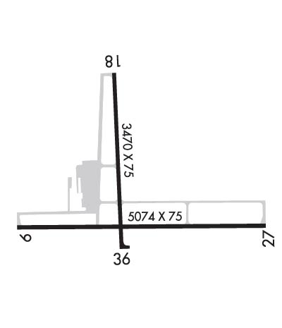
Runway Identification: 09/27 Length: 5074 ftWidth: 75 ftSurface: ASPHALT-FAIR CONDITIONEdge lights: Medium Intensity Treatment: NONE Runway: 09 Runway: 27 Mag heading: 88° Mag heading: 268° Rwy Slope: .01% Up Rwy Slope: -.01% Down Approach: Approach: Pattern: Left Traffic Pattern: Left Traffic Markings: NONPRECISION INSTRUMENT Markings: NONPRECISION INSTRUMENT Marking Condition: FAIR Marking Condition: FAIR Arresting Dev: Arresting Dev: Lat & Long: N4453.4 W09152.6 Lat. & Long.: N4453.5 W09151.4 Elev: 892.2 ft. MSL Elev: 892.8 ft. MSL TCH: 48 ft. AGL TCH: 45 ft. AGL Visual Glide Path: 3.00 degrees Visual Glide Path: 3.00 degrees Displaced Threshold: No Displaced Threshold: No Touchdown Zone: YES Touchdown Zone: YES Touchdown Elev.: 893.6 feet Touchdown Elev.: 893.6 feet Visual Glide Slope: 2-Light PAPI on LEFT side of Runway Visual Glide Slope: 2-Light PAPI on LEFT side of Runway RVR Equipment: RVR Equipment: RVV Equipment: NO RVV Equipment: NO Approach Lights: Approach Lights: REIL: YES REIL: YES Centerline Lights: NO Centerline Lights: NO Touchdown lights: NO Touchdown lights: NO Runway Category: D Runway Category: D Declared Distances: Declared Distances: Obstructions: FARM EQUIP. Obstructions: OTHER Marked: NOT Marked/Lighted Marked: NOT Marked/Lighted Clearance slope: 34:1; CTLNG OBSTN EXCEEDS A 45 DEG SLP. Clearance slope: Obstruction height: Obstruction height: 15 feet AGL Dist. from runway: Dist. from runway: 200 feet Centerline offset: Centerline offset: 300 feet left of centerline Comments: Comments: 20 FT BLDG 100 FT FM RWY END, 325 FT L.
Runway Identification: 18/36 Length: 3470 ftWidth: 75 ftSurface: ASPHALT-FAIR CONDITIONEdge lights: Medium Intensity Treatment: NONE Runway: 18 Runway: 36 Mag heading: 176° Mag heading: 356° Rwy Slope: -.06% Down Rwy Slope: .06% Up Approach: Approach: Pattern: Left Traffic Pattern: Left Traffic Markings: NONPRECISION INSTRUMENT Markings: NONPRECISION INSTRUMENT Marking Condition: FAIR Marking Condition: FAIR Arresting Dev: Arresting Dev: Lat & Long: N4454.0 W09152.1 Lat. & Long.: N4453.4 W09152.1 Elev: 895.1 ft. MSL Elev: 893.0 ft. MSL TCH: 43 ft. AGL TCH: 39 ft. AGL Visual Glide Path: 3.00 degrees Visual Glide Path: 3.00 degrees Displaced Threshold: No Displaced Threshold: No Touchdown Zone: YES Touchdown Zone: YES Touchdown Elev.: 895.1 feet Touchdown Elev.: 893.6 feet Visual Glide Slope: 2-Light PAPI on LEFT side of Runway Visual Glide Slope: 2-Light PAPI on RIGHT side of Runway RVR Equipment: RVR Equipment: RVV Equipment: NO RVV Equipment: NO Approach Lights: Approach Lights: REIL: NO REIL: NO Centerline Lights: NO Centerline Lights: NO Touchdown lights: NO Touchdown lights: NO Runway Category: Runway with a Visual Approach Runway Category: Runway with a Visual Approach Declared Distances: Declared Distances: