| |||||||||||||||||||||||||||||||||||||||||||||||||||||||||||||
| |||||||||||||||||||||||||||||||||||||||||||||||||||||||||||||
| |||||||||||||||||||||||||||||||||||||||||||||||||||||||||||||
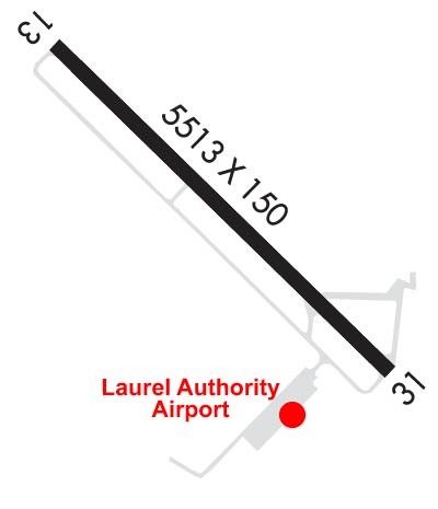
| Rwy | Rwy | |||||||
| 5513x150 | 5513' | 5513x150 | 5513' | |||||
| Runway ID | Single Wheel | Double Wheel | Double Tandem Wheel | Dual Double Wheel |
| 13/31 | 41,000 | 65,000 | 110,000 | N/A |
| These numbers are Advisory and are not limits. The Airport Manager should have more accurate Weight Limits | ||||
 Airport Diagram might not be current. | |
| Facility Name: | HESLER-NOBLE FLD |
| City Name: | LAUREL |
| County: | JONES |
| State abbrev: | MS |
| State Name: | MISSISSIPPI |
| Ownership: | PUBLICLY OWNED |
| Use: | OPEN TO THE PUBLIC |
| Owner's Name: | LAUREL AIRPORT AUTHORITY |
| Address: | PO BOX 2335 |
| LAUREL, MS 39442 | |
| Owner's Phone: | 601-425-5121 |
| Manager's Name: | MATTHEW OWENS |
| Address: | PO BOX 2335 |
| LAUREL, MS 39442 | |
| Phone: | 601-425-5121 |
| FAA Region: | SOUTHERN |
| FAA Field Office: | JAN |
| Date | Sunrise | Sunset |
|---|---|---|
| 04/19/24 Friday | 6:23 | 19:29 |
| 04/20/24 Saturday | 6:22 | 19:30 |
| 04/21/24 Sunday | 6:21 | 19:30 |
| 04/22/24 Monday | 6:20 | 19:31 |
| 04/23/24 Tuesday | 6:19 | 19:32 |
| 04/24/24 Wednesday | 6:17 | 19:32 |
| 04/25/24 Thursday | 6:16 | 19:33 |
| 04/26/24 Friday | 6:15 | 19:34 |
| 04/27/24 Saturday | 6:14 | 19:34 |
| 04/28/24 Sunday | 6:13 | 19:35 |
| 04/29/24 Monday | 6:12 | 19:36 |
| 04/30/24 Tuesday | 6:12 | 19:37 |
| 05/01/24 Wednesday | 6:11 | 19:37 |
| 05/02/24 Thursday | 6:10 | 19:38 |
| Airport Attendance Schedule | MON-FRI 0730-1800, SAT 0900-1800, SUN 1300-1800; AFT HR SVC CALL 601-426-2626. |
| Airport Status | OPERATIONAL (This Status can change at any time - please check NOTAMS) |
| Airport Lighting Schedule | ACTVT REIL RWY 13; HIRL RWY 13/31 - CTAF. PAPI RWY 13 & 31 OPR CONSLY. |
| Airport Storage Available | Tie Downs, Hanger |
| Extra Services Available | NONE |
| Wind Indicator | YES - (lighted) |
| Control Tower | NO |
| CTAF Frequency | 123.050 |
| Unicom Frequency | 123.050 |
| Rotating Beacon Color | WG |
| Segmented Circle | YES |
| Landing Fee | NO |
| Airport Inspected | STATE - performed by STATE AERONAUTICAL PERSONNEL |
| Inspection Date | 03/30/2023 |
| Type of Fuel Available | Grade 100LL, JET A-1 (icing inhibitor, freeze point -50C) |
| Airframe Repair Service | MINOR |
| Power Plant Repair Service | MINOR |
| Latitude | N3140.4 |
| Longitude | W08910.4 (ESTIMATED) |
| Arpt Elevation | 238ft (SURVEYED) |
| Magnetic Variation | 00E |
| 3 miles SW | of LAUREL |
| Traffic Pattern Altitude | |
| Sectional Chart | NEW ORLEANS |
| Operations (Reported) | Yearly | Avg. Daily |
|---|---|---|
| General Aviation Transient | 8717 | 24 |
| General Aviation Local | 17924 | 49 |
| Air Taxi | 0 | 0 |
| Commerical | 0 | 0 |
| Commuter | 0 | 0 |
| Military | 1522 | 4 |
| Aircraft based on Field | |
|---|---|
| General Aviation Singles | 13 |
| General Aviation Multi | 5 |
| Jet Aircraft | 6 |
| General Aviation Helicopters | 0 |
| Military Aircraft | 0 |
| Gliders | 1 |
| Ultralights | 0 |
| FSS on field | NO |
| FSS tie-in | GREENWOOD |
| FSS Phone | 1-800-WX-BRIEF |
| Who issues Notams | GWO |
| Notam D service at airport | YES |
| ARTCC Name | MEMPHIS |
| Airport Certification | |
| Aircraft Rescue & Firefighting Index | None |
| Airport of Entry | No |
| Custom Landing Rights | No |
| Joint Civil/Military | No |
| Military Landing rights | YES |
| NATIONAL PLAN OF INTEGRATED AIRPORT SYSTEMS (NPIAS) |
| GRANT AGREEMENTS UNDER FAAP/ADAP/AIP |
| SURPLUS PROPERTY AGREEMENT UNDER PUBLIC LAW 289 |
| ASSURANCES PURSUANT TO TITLE VI, CIVIL RIGHTS ACT OF 1964 |
| AGREEMENT UNDER DLAND OR DCLA HAS EXPIRED. |
| ULTRALIGHT & CROP DUST ACTV INVOF ARPT. |
| FOR CD IF UNA TO CTC ON FSS FREQ, CTC HOUSTON ARTCC AT 281-230-5622. |
| COURTESY VEHICLE AVBL. |
| FULL SVC FUEL WITH CREDIT CARD. |
Airport Communications & Frequencies:
| |||||||||
| Runway: 13 | Runway: 31 | ||
| Mag heading: | 135° | Mag heading: | 315° |
| Rwy Slope: | .10% Up | Rwy Slope: | -.10% Down |
| Approach: | Approach: | ||
| Pattern: | Left Traffic | Pattern: | Left Traffic |
| Markings: | NONPRECISION INSTRUMENT | Markings: | NONPRECISION INSTRUMENT |
| Marking Condition: | FAIR | Marking Condition: | FAIR |
| Arresting Dev: | Arresting Dev: | ||
| Lat & Long: | N3140.7 W08910.7 | Lat. & Long.: | N3140.1 W08910.0 |
| Elev: | 228.6 ft. MSL | Elev: | 234.3 ft. MSL |
| TCH: | 40 ft. AGL | TCH: | 40 ft. AGL |
| Visual Glide Path: | 3.00 degrees | Visual Glide Path: | 3.00 degrees |
| Displaced Threshold: | No | Displaced Threshold: | No |
| Touchdown Zone: | YES | Touchdown Zone: | YES |
| Touchdown Elev.: | 238.3 feet | Touchdown Elev.: | 238.3 feet |
| Visual Glide Slope: | 4-Light PAPI on LEFT side of Runway | Visual Glide Slope: | 4-Light PAPI on LEFT side of Runway; PAPI UNUSBL BYD 9 DEGS RIGHT OF CNTRLN. |
| RVR Equipment: | RVR Equipment: | ||
| RVV Equipment: | NO | RVV Equipment: | NO |
| Approach Lights: | Approach Lights: | ||
| REIL: | YES | REIL: | NO |
| Centerline Lights: | NO | Centerline Lights: | NO |
| Touchdown lights: | NO | Touchdown lights: | NO |
| Runway Category: | Runway with a Non-precision Approach having visibility minimums greater than 3/4 mile | Runway Category: | Runway with a Non-precision Approach having visibility minimums greater than 3/4 mile |
| Declared Distances: | Declared Distances: | ||
| Obstructions: | Unknown | Obstructions: | TREES |
| Marked: | NOT Marked/Lighted | Marked: | NOT Marked/Lighted |
| Clearance slope: | 34:1 | Clearance slope: | 34:1 |
| Obstruction height: | 33 feet AGL | Obstruction height: | 55 feet AGL |
| Dist. from runway: | Dist. from runway: | 2124 feet | |
| Centerline offset: | Centerline offset: | B | |
| Comments: | Comments: |