Welcome to Signature Aviation, where uniting exceptional customer service and uncompromising safety standards is our primary focus. Toll Free # 800.359.7224.
Misc. Info: 7 days a week, open at 05:00 am close at 12:00 midnight. Available after hours by request.
Address: 358 WILMER AVE. CINCINNATI, OH 45226
FlightLogix is the choice of discerning aircraft owners for aircraft maintenance. We are locally owned and operated. - Piston and light turbine maintenance - Authorized Cirrus Service Center - ICON Service Center
NOW OPEN! Best full service FBO on the field at Cincinnati's Lunken Airport. Our privately owned FBO brings back to Lunken Airport a personal experience in Aviation and a commitment to cultivating relationships.
These numbers are Advisory and are not limits. The Airport Manager should have more accurate Weight Limits
Approach Charts
Current Weather/Notams (Metars, TAFs, Notams, NWS Forecast, PIREPS, and nearby weather)
Customs Information Send updates to Support@FltPlan.com
Phone 859-767-7002 Fax 859-767-7011
Comments 2 hrs advance notice required. Business hrs 0900-1700 Monday-Friday. *Maximum passengers per flight: 15 *Call prior to 1700 on preceeding weekday for after-hours or weekend service
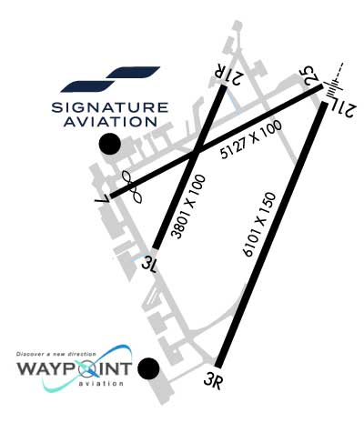
Length: 3801 ft Width: 100 ft Surface: ASPHALT-FAIR CONDITION Edge lights: Medium Intensity Treatment: NONE Weight: PCN 6 /F/C/Y/T
Runway: 03L
Runway: 21R
Mag heading:
27°
Mag heading:
207°
Rwy Slope:
-.13% Down
Rwy Slope:
.13% Up
Approach:
Approach:
Pattern:
Left Traffic
Pattern:
Left Traffic
Markings:
BASIC
Markings:
BASIC
Marking Condition:
FAIR
Marking Condition:
FAIR
Arresting Dev:
Arresting Dev:
Lat & Long:
N3906.0 W08425.4
Lat. & Long.:
N3906.6 W08425.1
Elev:
483.3 ft. MSL
Elev:
478.4 ft. MSL
TCH:
TCH:
46 ft. AGL
Visual Glide Path:
Visual Glide Path:
4.00 degrees
Displaced Threshold:
No
Displaced Threshold:
No
Touchdown Zone:
YES
Touchdown Zone:
YES
Touchdown Elev.:
483.3 feet
Touchdown Elev.:
481.1 feet
Visual Glide Slope:
Visual Glide Slope:
4-BOX VASI ON LEFT SIDE OF RUNWAY
RVR Equipment:
RVR Equipment:
RVV Equipment:
NO
RVV Equipment:
NO
Approach Lights:
Approach Lights:
REIL:
NO
REIL:
NO
Centerline Lights:
NO
Centerline Lights:
NO
Touchdown lights:
NO
Touchdown lights:
NO
Runway Category:
Runway with a Visual Approach
Runway Category:
Runway with a Visual Approach
Declared Distances:
Declared Distances:
Obstructions:
TREES
Obstructions:
PLINE
Marked:
NOT Marked/Lighted
Marked:
NOT Marked/Lighted
Clearance slope:
14:1
Clearance slope:
41:1
Obstruction height:
77 feet AGL
Obstruction height:
52 feet AGL
Dist. from runway:
1307 feet
Dist. from runway:
2375 feet
Centerline offset:
202 left of centerline
Centerline offset:
200 feet right of centerline
Comments:
Comments:
Runway Identification: 03R/21L
Length: 6101 ft Width: 150 ft Surface: ASPHALT Edge lights: High Intensity Treatment: GROOVED Weight: PCN 42 /R/C/X/T
Runway: 03R
Runway: 21L
Mag heading:
25°
Mag heading:
205°
Rwy Slope:
-.10% Down
Rwy Slope:
.10% Up
Approach:
Approach:
ILS/DME
Pattern:
Left Traffic
Pattern:
Left Traffic
Markings:
NONPRECISION INSTRUMENT
Markings:
PRECISION INSTRUMENT
Marking Condition:
FAIR
Marking Condition:
FAIR
Arresting Dev:
Arresting Dev:
Lat & Long:
N3905.6 W08425.2
Lat. & Long.:
N3906.5 W08424.7
Elev:
481.1 ft. MSL
Elev:
475.1 ft. MSL
TCH:
44 ft. AGL
TCH:
39 ft. AGL
Visual Glide Path:
3.00 degrees
Visual Glide Path:
3.00 degrees
Displaced Threshold:
No
Displaced Threshold:
No
Touchdown Zone:
YES
Touchdown Zone:
YES
Touchdown Elev.:
481.1 feet
Touchdown Elev.:
475.2 feet
Visual Glide Slope:
4-Light PAPI on RIGHT side of Runway; UNUSBL BYD 7 DEGS L OF CNTRLN.
Visual Glide Slope:
4-Light PAPI on LEFT side of Runway
RVR Equipment:
ROLLOUT
RVR Equipment:
TOUCHDOWN
RVV Equipment:
NO
RVV Equipment:
NO
Approach Lights:
Approach Lights:
MALSR - 1,400 foot medium intensity approach lighting system with runway alignment indicator lights
REIL:
YES
REIL:
NO
Centerline Lights:
NO
Centerline Lights:
NO
Touchdown lights:
NO
Touchdown lights:
NO
Runway Category:
Runway with a Non-precision Approach having visibility minimums greater than 3/4 mile
Runway Category:
Precision Instrument Runway
Declared Distances:
TORA:6101' TODA:6101' ASDA:6101' LDA:6101'
Declared Distances:
TORA:6101' TODA:6101' ASDA:6101' LDA:6101'
Obstructions:
TREE
Obstructions:
TREES
Marked:
NOT Marked/Lighted
Marked:
NOT Marked/Lighted
Clearance slope:
24:1
Clearance slope:
34:1
Obstruction height:
78 feet AGL
Obstruction height:
36 feet AGL
Dist. from runway:
2111 feet
Dist. from runway:
1427 feet
Centerline offset:
743 right of centerline
Centerline offset:
320 feet right of centerline
Comments:
Comments:
Runway Identification: 07/25
Length: 5127 ft Width: 100 ft Surface: ASPHALT-FAIR CONDITION Edge lights: Medium Intensity Treatment: GROOVED Weight: PCN 38 /R/C/X/T
Runway: 07
Runway: 25
Mag heading:
66°
Mag heading:
246°
Rwy Slope:
-.13% Down
Rwy Slope:
.13% Up
Approach:
Approach:
Pattern:
Left Traffic
Pattern:
Left Traffic
Markings:
NONPRECISION INSTRUMENT
Markings:
NONPRECISION INSTRUMENT
Marking Condition:
FAIR
Marking Condition:
FAIR
Arresting Dev:
Arresting Dev:
Lat & Long:
N3906.2 W08425.7
Lat. & Long.:
N3906.6 W08424.7
Elev:
481.5 ft. MSL
Elev:
474.9 ft. MSL
TCH:
TCH:
40 ft. AGL
Visual Glide Path:
Visual Glide Path:
3.00 degrees
Displaced Threshold:
439 feet
Displaced Threshold:
No
Touchdown Zone:
YES
Touchdown Zone:
YES
Touchdown Elev.:
481.6 feet
Touchdown Elev.:
477.8 feet
Visual Glide Slope:
Visual Glide Slope:
4-BOX VASI ON LEFT SIDE OF RUNWAY
RVR Equipment:
RVR Equipment:
RVV Equipment:
NO
RVV Equipment:
NO
Approach Lights:
Approach Lights:
REIL:
NO
REIL:
NO
Centerline Lights:
NO
Centerline Lights:
NO
Touchdown lights:
NO
Touchdown lights:
NO
Runway Category:
Runway with a Visual Approach
Runway Category:
Runway with a Non-precision Approach having visibility minimums greater than 3/4 mile
Declared Distances:
Declared Distances:
Obstructions:
TREE
Obstructions:
Marked:
NOT Marked/Lighted
Marked:
Clearance slope:
12:1; 23:1 TO DTHR.
Clearance slope:
34:1
Obstruction height:
59 feet AGL
Obstruction height:
Dist. from runway:
920 feet
Dist. from runway:
Centerline offset:
50 left of centerline
Centerline offset:
Comments:
HANGAR & PARKED ACFT; +36 FT ANT ON HANGAR, 177 FT DIST TO THR, 615 FT DIST TO DTHR, 157 FT R OF CNTRLN. APCH RATIO 0:1 TO THR; APCH RATIO 11:1 TO DTHR.