Click here for more info on on SMS!

KLUD

DECATUR MUNI
DECATUR
TX
Time Zone: Central
Lat: N 3315.3
Long: W 09734.8
Elev: 1047
Var: -09
Longest Runway: 4200
AWOS: 118.22
CTAF: 122.8

FBO & Flight Services info for KLUD

FBOs: Update your Fuel Prices

DECATUR JET CTRPh: 940-627-1050 Fax: 940-627-1044 Freq: 122.8
Service
Jet
100LL
SAF
MoGas
Fuel Avail: 24/7 Self Service/ Jet -A Surcharge after hours for full service only
Full5.995.99    Last Update: 04/16/2024 09:49

Guaranteed
Self4.994.99    
 Address: 351 AIRPORT ROAD   DECATUR, TX 76234
AWOSPh: 940-627-2365
-
Freq: 118.22  
If you are an FBO, call 1-203-262-1700 to update your info or email: FltPlan.Advertising@garmin.com
Advertise your FBO on FltPlan.com

Runway & Approach Info for KLUD
Rwy
Length
Land Dist**
Approach*
  Rwy
Length
Land Dist**
Approach*
17
4200x60  4200'          
 
  
35
  4200x60  4200'          
 
 * only ILS, LOC, LDA, and SDF approaches to a specific runway are shown
** For any Declared Landing Distance Available, please see A/FD or Approach plates
Runway Weight Capability (lbs.) Help
Runway IDSingle WheelDouble WheelDouble Tandem WheelDual Double Wheel
17/3512,50017,000N/AN/A
These numbers are Advisory and are not limits.   The Airport Manager should have more accurate Weight Limits
Approach Charts
Approaches    
Current Weather/Notams
Customs Information Send updates to Support@FltPlan.com
Customs Not Available
Database effective 04/18/2024
Airport Diagram of KLUD
Airport Diagram might not be current.

Facility Name: DECATUR MUNI
City Name: DECATUR
County: WISE
State abbrev: TX
State Name: TEXAS
   
Ownership: PUBLICLY OWNED
Use: OPEN TO THE PUBLIC
Owner's Name: CITY OF DECATUR
Address: PO BOX 1299
 DECATUR, TX 76234
Owner's Phone: 940-393-0200
  
Manager's Name: GREG HALL
Address: 351 AIRPORT ROAD
 DECATUR, TX 76234
Phone: 940-627-2855; DIR OF PUBLIC WORKS/AMGR ADDNL PHONE: 940-393-0262.
   
FAA Region: SOUTHWEST
FAA Field Office: TEX


Sunrise / Sunset times for DECATUR MUNI

DateSunriseSunset
04/17/24 Wednesday6:5720:03
04/18/24 Thursday6:5620:04
04/19/24 Friday6:5520:05
04/20/24 Saturday6:5320:05
04/21/24 Sunday6:5220:06
04/22/24 Monday6:5120:07
04/23/24 Tuesday6:5020:07
04/24/24 Wednesday6:4920:08
04/25/24 Thursday6:4820:09
04/26/24 Friday6:4720:10
04/27/24 Saturday6:4620:10
04/28/24 Sunday6:4520:11
04/29/24 Monday6:4420:12
04/30/24 Tuesday6:4320:13

Airport Facilities

Airport Attendance Schedule7 Days A Week 0800-1700
Airport Status OPERATIONAL (This Status can change at any time - please check NOTAMS)
Airport Lighting ScheduleDUSK-DAWN. MIRL RWY 17/35 PRESET LOW INTST; TO INCR INTST ACTVT - CTAF.
Airport Storage AvailableTie Downs, Hanger
Extra Services AvailableFlight Instruction, Aircraft Rental, Aircraft Sales
Wind IndicatorYES - (lighted)
Control TowerNO
CTAF Frequency122.800
Unicom Frequency122.800
Rotating Beacon ColorWG
Segmented CircleYES
Landing FeeNO

Airport Inspection Data

Airport InspectedSTATE - performed by PRIVATE CONTRACT PERSONNEL
Inspection Date09/19/2022

Airport Services

Type of Fuel AvailableGrade 100LL, JET A (freeze point -40C)
Airframe Repair ServiceMAJOR
Power Plant Repair ServiceMAJOR

Geographic Data

LatitudeN3315.3
LongitudeW09734.8 (ESTIMATED)
Arpt Elevation1046ft (SURVEYED)
Magnetic Variation09E
2 miles Nof DECATUR
Traffic Pattern Altitude
Sectional ChartDALLAS-FT WORTH

Aircraft Data

Operations (Reported)YearlyAvg. Daily
General Aviation Transient 2737575
General Aviation Local 912525
Air Taxi 00
Commerical 00
Commuter 00
Military 00
Aircraft based on Field
General Aviation Singles 28
General Aviation Multi 3
Jet Aircraft 0
General Aviation Helicopters 8
Military Aircraft 0
Gliders 2
Ultralights 0

FAA Services

FSS on field NO
FSS tie-in FORT WORTH
FSS Phone 1-800-WX-BRIEF
Who issues Notams LUD
Notam D service at airport YES
ARTCC Name FORT WORTH

Federal Status

Airport Certification
Aircraft Rescue & Firefighting IndexNone
Airport of EntryNo
Custom Landing RightsNo
Joint Civil/MilitaryNo
Military Landing rightsYES

Federal Agreements

NATIONAL PLAN OF INTEGRATED AIRPORT SYSTEMS (NPIAS)
ASSURANCES PURSUANT TO TITLE VI, CIVIL RIGHTS ACT OF 1964
GRANT AGREEMENT HAS EXPIRED; HOWEVER, AGREEMENT REMAINS IN EFFECT FOR THIS FACILITY AS LONG AS IT IS PUBLIC USE.

Remarks

GND DROPS SHARPLY 160 FT NORTH OF RWY 17 THR.
DEER AND WILDLIFE ON & INVOF ARPT.
FOR CD CTC REGIONAL APCH AT 972-615-2799.
DUE TO RWY ELEV CHG, ACFT NOT VSB AT OPPOSITE END.
Airport Communications & Frequencies:
CTAF Frequency:
122.800
Unicom Frequency:
122.800
REGIONAL Primary Approach Frequencies:  
118.1
306.95
REGIONAL Primary Departure Frequencies:  
118.1
306.95
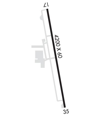
Runway Identifications
Runway Identification: 17/35
Length: 4200 ft
Width: 60 ft
Surface: ASPHALT-GOOD CONDITION
Edge lights: Medium Intensity

Treatment: NONE

 Runway: 17   Runway: 35
Mag heading: 163°Mag heading: 343°
Rwy Slope: -.10% DownRwy Slope: .10% Up
Approach: Approach:
Pattern: Left TrafficPattern: Right Traffic
Markings: NONPRECISION INSTRUMENTMarkings: NONPRECISION INSTRUMENT
Marking Condition: FAIRMarking Condition: FAIR
Arresting Dev: Arresting Dev:
Lat & Long: N3315.6  W09734.9Lat. & Long.: N3314.9  W09734.8
Elev: 1041.2 ft. MSLElev: 1036.9 ft. MSL
TCH: 23 ft. AGLTCH: 40 ft. AGL
Visual Glide Path: 3.50 degreesVisual Glide Path: 3.50 degrees
Displaced Threshold: NoDisplaced Threshold: No
Touchdown Zone: YESTouchdown Zone: YES
Touchdown Elev.: 1046.7 feetTouchdown Elev.: 1046.7 feet
Visual Glide Slope: 2-Light PAPI on LEFT side of RunwayVisual Glide Slope: 2-Light PAPI on LEFT side of Runway
RVR Equipment: RVR Equipment:
RVV Equipment: NORVV Equipment: NO
Approach Lights: Approach Lights:
REIL: YESREIL: NO
Centerline Lights: NOCenterline Lights: NO
Touchdown lights: NOTouchdown lights: NO
Runway Category: Runway with a Non-precision ApproachRunway Category: Runway with a Non-precision Approach
Declared Distances: Declared Distances:
Obstructions: TREE; ALSO 30 FT MKD PLINE, 770 FT DSTC, ACRS APCH.Obstructions: TREES
Marked: NOT Marked/LightedMarked: MARKED
Clearance slope: 4:1Clearance slope:
Obstruction height: 10 feet AGLObstruction height: 15 feet AGL
Dist. from runway: 243 feetDist. from runway: 201 feet
Centerline offset: 125 right of centerlineCenterline offset: 230 feet right of centerline
Comments: 6 FT BRUSH 50 FT FM THR TO 200 FT FM THR, 240-250 FT R.Comments: 20 FT TREES, 140-199 FT DSTC, 150-250 FT R.
C:2/P: