Click here for more info on on SMS!

KLSK

LUSK MUNI
LUSK
WY
Time Zone: Mountain
Lat: N 4245.2
Long: W 10424.3
Elev: 4967
Var: -12
Longest Runway: 5058
AWOS: 118.35
CTAF: 122.8

FBO & Flight Services info for KLSK

FBOs: Update your Fuel Prices

TOWN OF LUSKPh: 307-334-3622 Fax: 307-334-2154 Freq: 122.8
Service
Jet
100LL
SAF
MoGas
Fuel Avail: HRS 7A-4P MON-FRI
Full  5.60    Caution: Fuel prices have not been updated in 35 days.
Last Update: 03/22/2024 12:01

Self  5.60    
 Address: AIRPORT, 4369 HWY US 20   LUSK, WY 82225
AWOSPh: 307-334-4028
-
Freq: 118.35  
If you are an FBO, call 1-203-262-1700 to update your info or email: FltPlan.Advertising@garmin.com
Advertise your FBO on FltPlan.com

Runway & Approach Info for KLSK
Rwy
Length
Land Dist**
Approach*
  Rwy
Length
Land Dist**
Approach*
10
5058x75  5058'          
 
  
28
  5058x75  5058'          
 
 * only ILS, LOC, LDA, and SDF approaches to a specific runway are shown
** For any Declared Landing Distance Available, please see A/FD or Approach plates
Runway Weight Capability (lbs.) Help
Runway IDSingle WheelDouble WheelDouble Tandem WheelDual Double Wheel
10/2812,500N/AN/AN/A
These numbers are Advisory and are not limits.   The Airport Manager should have more accurate Weight Limits
Approach Charts
FltPlan does not have IFR approach charts available for KLSK.
Current Weather/Notams
Customs Information Send updates to Support@FltPlan.com
Customs Not Available
Database effective 05/16/2024
Airport Diagram of KLSK
Airport Diagram might not be current.

Facility Name: LUSK MUNI
City Name: LUSK
County: NIOBRARA
State abbrev: WY
State Name: WYOMING
   
Ownership: PUBLICLY OWNED
Use: OPEN TO THE PUBLIC
Owner's Name: TOWN OF LUSK
Address: BOX 390
 LUSK, WY 82225
Owner's Phone: 307-334-3612
  
Manager's Name: ROYCE THOMPSON
Address: BOX 390
 LUSK, WY 82225
Phone: 307-334-3622
   
FAA Region: NORTHWEST MOUNTAIN
FAA Field Office: DEN


Sunrise / Sunset times for LUSK MUNI

DateSunriseSunset
04/25/24 Thursday5:5919:52
04/26/24 Friday5:5819:53
04/27/24 Saturday5:5619:54
04/28/24 Sunday5:5519:56
04/29/24 Monday5:5419:57
04/30/24 Tuesday5:5219:58
05/01/24 Wednesday5:5119:59
05/02/24 Thursday5:5020:00
05/03/24 Friday5:4820:01
05/04/24 Saturday5:4720:02
05/05/24 Sunday5:4620:03
05/06/24 Monday5:4420:05
05/07/24 Tuesday5:4320:06
05/08/24 Wednesday5:4220:07

Airport Facilities

Airport Attendance ScheduleUNATTENDED
Airport Status OPERATIONAL (This Status can change at any time - please check NOTAMS)
Airport Lighting ScheduleACTVT REIL RWY 28; PAPI RWY 10 & 28; MIRL RWY 10/28 - 122.8.
Airport Storage AvailableTie Downs
Extra Services AvailableNONE
Wind IndicatorYES - (lighted)
Control TowerNO
CTAF Frequency122.800
Unicom Frequency122.800
Rotating Beacon ColorWG
Segmented CircleNO
Landing FeeNO

Airport Inspection Data

Airport InspectedSTATE - performed by STATE AERONAUTICAL PERSONNEL
Inspection Date08/03/2023

Airport Services

Type of Fuel AvailableGrade 100LL; -10AVBL VIA CREDIT CARD READER.
Airframe Repair ServiceNONE
Power Plant Repair ServiceNONE

Geographic Data

LatitudeN4245.2
LongitudeW10424.3 (ESTIMATED)
Arpt Elevation4966ft (SURVEYED)
Magnetic Variation12E
3 miles Eof LUSK
Traffic Pattern Altitude
Sectional ChartCHEYENNE

Aircraft Data

Operations (Reported)YearlyAvg. Daily
General Aviation Transient 12243
General Aviation Local 14004
Air Taxi 1020
Commerical 00
Commuter 00
Military 00
Aircraft based on Field
General Aviation Singles 12
General Aviation Multi 0
Jet Aircraft 0
General Aviation Helicopters 1
Military Aircraft 0
Gliders 0
Ultralights 0

FAA Services

FSS on field NO
FSS tie-in CASPER
FSS Phone 1-800-WX-BRIEF
Who issues Notams CPR
Notam D service at airport YES
ARTCC Name DENVER

Federal Status

Airport Certification
Aircraft Rescue & Firefighting IndexNone
Airport of EntryNo
Custom Landing RightsNo
Joint Civil/MilitaryNo
Military Landing rightsYES

Federal Agreements

NATIONAL PLAN OF INTEGRATED AIRPORT SYSTEMS (NPIAS)
GRANT AGREEMENTS UNDER FAAP/ADAP/AIP
ASSURANCES PURSUANT TO TITLE VI, CIVIL RIGHTS ACT OF 1964

Remarks

FOR CD IF UNA TO CTC ON FSS FREQ, CTC DENVER ARTCC AT 303-651-4257.
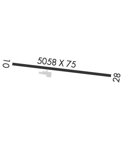
Runway Identifications
Runway Identification: 10/28
Length: 5058 ft
Width: 75 ft
Surface: ASPHALT-GOOD CONDITION
Edge lights: Medium Intensity

Treatment: NONE

 Runway: 10   Runway: 28
Mag heading: 104°Mag heading: 284°
Rwy Slope: -.25% DownRwy Slope: .25% Up
Approach: Approach:
Pattern: Left TrafficPattern: Left Traffic
Markings: NONPRECISION INSTRUMENTMarkings: NONPRECISION INSTRUMENT
Marking Condition: GOODMarking Condition: GOOD
Arresting Dev: Arresting Dev:
Lat & Long: N4245.4  W10424.8Lat. & Long.: N4245.0  W10423.8
Elev: 4966.7 ft. MSLElev: 4954.3 ft. MSL
TCH: 40 ft. AGLTCH: 40 ft. AGL
Visual Glide Path: 3.00 degreesVisual Glide Path: 3.00 degrees
Displaced Threshold: NoDisplaced Threshold: No
Touchdown Zone: YESTouchdown Zone: YES
Touchdown Elev.: 4966.8 feetTouchdown Elev.: 4956.0 feet
Visual Glide Slope: 2-Light PAPI on LEFT side of RunwayVisual Glide Slope: 2-Light PAPI on LEFT side of Runway
RVR Equipment: RVR Equipment:
RVV Equipment: NORVV Equipment: NO
Approach Lights: Approach Lights:
REIL: NOREIL: YES
Centerline Lights: NOCenterline Lights: NO
Touchdown lights: NOTouchdown lights: NO
Runway Category: Runway with a Visual ApproachRunway Category: Runway with a Visual Approach
Declared Distances: Declared Distances:
Obstructions: POLEObstructions:
Marked: NOT Marked/LightedMarked:
Clearance slope: 13:1Clearance slope: 50:1
Obstruction height: 5 feet AGLObstruction height:
Dist. from runway: 268 feetDist. from runway:
Centerline offset: 48 left of centerlineCenterline offset:
Comments: Comments:
C:/P: