Click here for more info on on SMS!

KLRJ

LE MARS MUNI
LE MARS
IA
Time Zone: Central
Lat: N 4246.7
Long: W 09611.6
Elev: 1197
Var: -03
Longest Runway: 5056
AWOS: 120.97
CTAF: 122.8

FBO & Flight Services info for KLRJ

FBOs: Update your Fuel Prices

ULTRA FLIGHTPh: 712-540-1665 Fax: N/A Freq: 122.8
Service
Jet
100LL
SAF
MoGas
Fuel Avail: M-F Sat/Sunday on Request after hrs charge without 8 hr notice
Full5.526.18    Last Update: 03/27/2024 14:24

Self  6.08    
 Address: 1621 AIRPORT DR,   LEMARS, IA 51031
AWOSPh: 712-546-8439
-
Freq: 125.52  
If you are an FBO, call 1-203-262-1700 to update your info or email: FltPlan.Advertising@garmin.com
Advertise your FBO on FltPlan.com

Runway & Approach Info for KLRJ
Rwy
Length
Land Dist**
Approach*
  Rwy
Length
Land Dist**
Approach*
18
5056x75  4756'          
 
  
36
  5056x75  4756'          
 
 * only ILS, LOC, LDA, and SDF approaches to a specific runway are shown
** For any Declared Landing Distance Available, please see A/FD or Approach plates
Runway Weight Capability (lbs.) Help
Runway IDSingle WheelDouble WheelDouble Tandem WheelDual Double Wheel
18/3628,00048,000N/AN/A
These numbers are Advisory and are not limits.   The Airport Manager should have more accurate Weight Limits
Approach Charts
Approaches    
Current Weather/Notams
Customs Information Send updates to Support@FltPlan.com
Customs Not Available
Database effective 05/16/2024
Airport Diagram of KLRJ
Airport Diagram might not be current.

Facility Name: LE MARS MUNI
City Name: LE MARS
County: PLYMOUTH
State abbrev: IA
State Name: IOWA
   
Ownership: PUBLICLY OWNED
Use: OPEN TO THE PUBLIC
Owner's Name: CITY OF LE MARS
Address: 22 2ND ST SE
 LE MARS, IA 51031
Owner's Phone: 712-546-7018
  
Manager's Name: TOM MULLALLY
Address: 1621 AIRPORT DRIVE; EMAIL ADDRESS: ULTRAFLIGHTLLC51031@GMAIL.COM (ALL LOWER CASE)
 LE MARS, IA 51031
Phone: (712) 540-1665; AFTER HRS NMBR IS 712-540-1665
   
FAA Region: CENTRAL
FAA Field Office: NONE


Sunrise / Sunset times for LE MARS MUNI

DateSunriseSunset
04/22/24 Monday6:3120:16
04/23/24 Tuesday6:2920:17
04/24/24 Wednesday6:2820:18
04/25/24 Thursday6:2620:19
04/26/24 Friday6:2520:21
04/27/24 Saturday6:2420:22
04/28/24 Sunday6:2220:23
04/29/24 Monday6:2120:24
04/30/24 Tuesday6:1920:25
05/01/24 Wednesday6:1820:26
05/02/24 Thursday6:1720:27
05/03/24 Friday6:1520:28
05/04/24 Saturday6:1420:30
05/05/24 Sunday6:1320:31

Airport Facilities

Airport Attendance ScheduleMON-FRI 0800-1730, SAT- SUN PRIOR REQUEST
Airport Status OPERATIONAL (This Status can change at any time - please check NOTAMS)
Airport Lighting ScheduleACTVT REIL RWYS 18 & 36; PAPI RWY 18 & 36; MIRL RWY 18/36 - CTAF.
Airport Storage AvailableTie Downs, Hanger
Extra Services AvailableAircraft Sales
Wind IndicatorYES - (lighted)
Control TowerNO
CTAF Frequency122.800
Unicom Frequency122.800
Rotating Beacon ColorWG
Segmented CircleYES
Landing FeeNO

Airport Inspection Data

Airport InspectedSTATE - performed by STATE AERONAUTICAL PERSONNEL
Inspection Date09/28/2023

Airport Services

Type of Fuel AvailableGrade 100LL, JET A
Airframe Repair ServiceMINOR
Power Plant Repair ServiceMINOR

Geographic Data

LatitudeN4246.7
LongitudeW09611.6 (ESTIMATED)
Arpt Elevation1197ft (SURVEYED)
Magnetic Variation03E
2 miles SWof LE MARS
Traffic Pattern Altitude
Sectional ChartOMAHA

Aircraft Data

Operations (Reported)YearlyAvg. Daily
General Aviation Transient 15464
General Aviation Local 31829
Air Taxi 00
Commerical 00
Commuter 00
Military 220
Aircraft based on Field
General Aviation Singles 14
General Aviation Multi 0
Jet Aircraft 2
General Aviation Helicopters 0
Military Aircraft 0
Gliders 0
Ultralights 0

FAA Services

FSS on field NO
FSS tie-in FORT DODGE
FSS Phone 1-800-WX-BRIEF
Who issues Notams LRJ
Notam D service at airport YES
ARTCC Name MINNEAPOLIS

Federal Status

Airport Certification
Aircraft Rescue & Firefighting IndexNone
Airport of EntryNo
Custom Landing RightsNo
Joint Civil/MilitaryNo
Military Landing rightsYES

Federal Agreements

NATIONAL PLAN OF INTEGRATED AIRPORT SYSTEMS (NPIAS)
GRANT AGREEMENTS UNDER FAAP/ADAP/AIP
ASSURANCES PURSUANT TO TITLE VI, CIVIL RIGHTS ACT OF 1964

Remarks

AFT HRS SVC FEE.
RY 36 IS CALM WIND RY.
FOR CD CTC SIOUX CITY ATCT ON 124.6 OR CALL 712-293-2482.
COLD TEMPERATURE AIRPORT. ALTITUDE CORRECTION REQUIRED AT OR BELOW -24C.
Airport Communications & Frequencies:
CTAF Frequency:
122.800
Unicom Frequency:
122.800
Remarks
  • APCH/DEP SVC PRVDD BY MINNEAPOLIS ARTCC ON FREQS 125.025/235.625 (SIOUX CITY RCAG) WHEN SIOUX CITY ATCT CLSD.
  • SIOUX CITY Primary Approach Frequencies:  
    124.6
    307.0
    SIOUX CITY Primary Departure Frequencies:  
    124.6
    307.0
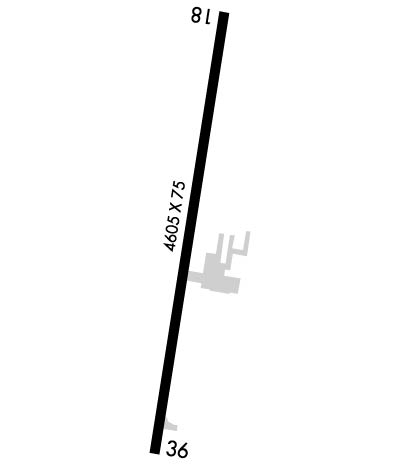
    Runway Identifications
    Runway Identification: 18/36
    Length: 5056 ft
    Width: 75 ft
    Surface: CONCRETE-GOOD CONDITION
    Edge lights: Medium Intensity

    Treatment: NONE
    Weight: PCN 12 /R/C/W/U

     Runway: 18   Runway: 36
    Mag heading: 185°Mag heading:
    Rwy Slope: -.01% DownRwy Slope: .01% Up
    Approach: Approach:
    Pattern: Right TrafficPattern: Left Traffic
    Markings: NONPRECISION INSTRUMENTMarkings: NONPRECISION INSTRUMENT
    Marking Condition: FAIRMarking Condition: FAIR
    Arresting Dev: Arresting Dev:
    Lat & Long: N4247.1  W09611.5Lat. & Long.: N4246.3  W09611.7
    Elev: 1193.7 ft. MSLElev: 1193.3 ft. MSL
    TCH: 21 ft. AGLTCH: 31 ft. AGL
    Visual Glide Path: 3.00 degreesVisual Glide Path: 3.00 degrees
    Displaced Threshold: 300 feet; 36:1 CLEARANCE TO DTHR.Displaced Threshold: 300 feet
    Touchdown Zone: YESTouchdown Zone: YES
    Touchdown Elev.: 1197.0 feetTouchdown Elev.: 1197.0 feet
    Visual Glide Slope: 2-Light PAPI on LEFT side of RunwayVisual Glide Slope: 2-Light PAPI on RIGHT side of Runway
    RVR Equipment: RVR Equipment:
    RVV Equipment: NORVV Equipment: NO
    Approach Lights: Approach Lights:
    REIL: YESREIL: YES
    Centerline Lights: NOCenterline Lights: NO
    Touchdown lights: NOTouchdown lights: NO
    Runway Category: Runway with a Non-precision Approach having visibility minimums greater than 3/4 mileRunway Category: Runway with a Non-precision Approach having visibility minimums greater than 3/4 mile
    Declared Distances: Declared Distances:
    Obstructions: TREEObstructions: ROAD
    Marked: NOT Marked/LightedMarked: NOT Marked/Lighted
    Clearance slope: 5:1; OBSTN SLOPE 50:1 TO DTHR.Clearance slope: 20:1; APCH SLOPE 33:1 TO DTHR.
    Obstruction height: 16 feet AGLObstruction height: 15 feet AGL
    Dist. from runway: 282 feetDist. from runway: 500 feet
    Centerline offset: 54 right of centerlineCenterline offset: 250 feet right of centerline
    Comments: 8 FT SHRUBS 25 FT FROM RWY END 85 FT RIGHT ON APCH.Comments:
    C:10/P: