Current Weather/Notams (Metars, TAFs, Notams, NWS Forecast, PIREPS, and nearby weather)
Customs Information Send updates to Support@FltPlan.com
Phone 956-728-8243Fax 956-723-4411Comments 1 hr advance notice required. Business hrs 0800-2400 Monday-Friday. *Call prior to 2400 on preceding weekday. *Fax pilot crew pax information prior to arrival. NEW telephone numbers are: (956) 728 8243 or (956) 728-8270. The US Customs and Border Protection (CBP) location at the Laredo TX airport (KLRD) has been moved from one side of the airfield to the other. Previously they were located on the east side of the airport. They are now located two (2) buildings SOUTH of the Control Tower on the WEST side of the airport adjacent to taxiway A.
Database effective 04/18/2024
Airport Diagram might not be current. Facility Name: LAREDO INTL City Name: LAREDO County: WEBB State abbrev: TX State Name: TEXAS Ownership: PUBLICLY OWNED Use: OPEN TO THE PUBLIC Owner's Name: CITY OF LAREDO Address: PO BOX 579 LAREDO, TX 78041 Owner's Phone: 956-791-7300 Manager's Name: GILBERTO SANCHEZ Address: 5210 BOB BULLOCK LOOP LAREDO, TX 78041 Phone: 956-795-2000 FAA Region: SOUTHWEST FAA Field Office: TEX
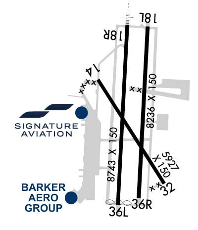
Runway Identifications Help
Runway Identification: 14/32 Length: 5927 ftWidth: 150 ftSurface: CONCRETE-GOOD CONDITIONEdge lights: Medium Intensity Treatment: NONE Runway: 14 Runway: 32 Mag heading: 142° Mag heading: 322° Rwy Slope: -.64% Down Rwy Slope: .64% Up Approach: Approach: Pattern: Left Traffic Pattern: Right Traffic Markings: NONPRECISION INSTRUMENT Markings: NONPRECISION INSTRUMENT Marking Condition: GOOD Marking Condition: GOOD Arresting Dev: Arresting Dev: Lat & Long: N2733.0 W09928.0 Lat. & Long.: N2732.1 W09927.4 Elev: 505.4 ft. MSL Elev: 467.4 ft. MSL TCH: 55 ft. AGL TCH: 71 ft. AGL Visual Glide Path: 3.00 degrees Visual Glide Path: 3.00 degrees Displaced Threshold: No Displaced Threshold: No Touchdown Zone: YES Touchdown Zone: YES Touchdown Elev.: 508.0 feet Touchdown Elev.: 493.6 feet Visual Glide Slope: 4-BOX VASI ON LEFT SIDE OF RUNWAY Visual Glide Slope: 4-BOX VASI ON LEFT SIDE OF RUNWAY RVR Equipment: RVR Equipment: RVV Equipment: NO RVV Equipment: NO Approach Lights: Approach Lights: REIL: NO REIL: NO Centerline Lights: NO Centerline Lights: NO Touchdown lights: NO Touchdown lights: NO Runway Category: Runway with a Non-precision Approach having visibility minimums greater than 3/4 mile Runway Category: Runway with a Non-precision Approach having visibility minimums greater than 3/4 mile Declared Distances: TORA:5927' TODA:5927' ASDA:5927' LDA:5927' Declared Distances: TORA:5927' TODA:5927' ASDA:5927' LDA:5927' Obstructions: Obstructions: ROAD Marked: Marked: NOT Marked/Lighted Clearance slope: 50:1 Clearance slope: Obstruction height: Obstruction height: 12 feet AGL Dist. from runway: Dist. from runway: 201 feet Centerline offset: Centerline offset: 250 feet right of centerline Comments: Comments:
Runway Identification: 18L/36R Length: 8236 ftWidth: 150 ftSurface: CONCRETE-GOOD CONDITIONEdge lights: High Intensity Treatment: GROOVED Runway: 18L Runway: 36R Mag heading: 178° Mag heading: 358° Rwy Slope: -.30% Down Rwy Slope: .30% Up Approach: Approach: Pattern: Left Traffic Pattern: Right Traffic Markings: NONPRECISION INSTRUMENT Markings: NONPRECISION INSTRUMENT Marking Condition: GOOD Marking Condition: GOOD Arresting Dev: Arresting Dev: Lat & Long: N2733.4 W09927.6 Lat. & Long.: N2732.0 W09927.6 Elev: 499.2 ft. MSL Elev: 474.2 ft. MSL TCH: 51 ft. AGL TCH: Visual Glide Path: 3.00 degrees Visual Glide Path: Displaced Threshold: No Displaced Threshold: No Touchdown Zone: YES Touchdown Zone: YES Touchdown Elev.: 499.2 feet Touchdown Elev.: 486.7 feet Visual Glide Slope: 4-Light PAPI on LEFT side of Runway Visual Glide Slope: RVR Equipment: RVR Equipment: RVV Equipment: NO RVV Equipment: NO Approach Lights: Approach Lights: REIL: NO REIL: NO Centerline Lights: NO Centerline Lights: NO Touchdown lights: NO Touchdown lights: NO Runway Category: Runway with a Non-precision Approach having visibility minimums greater than 3/4 mile Runway Category: Runway with a Visual Approach Declared Distances: TORA:8236' TODA:8236' ASDA:8236' LDA:8236' Declared Distances: TORA:8236' TODA:8236' ASDA:8236' LDA:8236'
Runway Identification: 18R/36L Length: 8743 ftWidth: 150 ftSurface: CONCRETE-GOOD CONDITIONEdge lights: High Intensity Treatment: GROOVED Runway: 18R Runway: 36L Mag heading: 178° Mag heading: 358° Rwy Slope: -.23% Down Rwy Slope: .23% Up Approach: ILS/DME Approach: Pattern: Left Traffic Pattern: Right Traffic Markings: PRECISION INSTRUMENT Markings: PRECISION INSTRUMENT Marking Condition: GOOD Marking Condition: GOOD Arresting Dev: EMAS; ENGINEERED MATERIALS ARRESTING SYSTEM (EMAS) 363 FT IN LENGTH BY 170 FT IN WIDTH LCTD AT THE DER 18R. Arresting Dev: Lat & Long: N2733.4 W09927.7 Lat. & Long.: N2731.9 W09927.8 Elev: 503.7 ft. MSL Elev: 483.7 ft. MSL TCH: 50 ft. AGL TCH: 50 ft. AGL Visual Glide Path: 3.00 degrees Visual Glide Path: 3.00 degrees Displaced Threshold: No Displaced Threshold: 120 feet Touchdown Zone: YES Touchdown Zone: YES Touchdown Elev.: 503.7 feet Touchdown Elev.: 497.0 feet Visual Glide Slope: 4-Light PAPI on LEFT side of Runway Visual Glide Slope: 4-Light PAPI on LEFT side of Runway RVR Equipment: RVR Equipment: RVV Equipment: NO RVV Equipment: NO Approach Lights: MALSR - 1,400 foot medium intensity approach lighting system with runway alignment indicator lights Approach Lights: REIL: NO REIL: NO Centerline Lights: NO Centerline Lights: NO Touchdown lights: NO Touchdown lights: NO Runway Category: Precision Instrument Runway Runway Category: Runway with a Non-precision Approach having visibility minimums greater than 3/4 mile Declared Distances: TORA:8743' TODA:8743' ASDA:8743' LDA:8743' Declared Distances: TORA:8743' TODA:8743' ASDA:8743' LDA:8623'