
| ||||||||||||||||||||||||||||||||||||||||||||
| ||||||||||||||||||||||||||||||||||||||||||||
| ||||||||||||||||||||||||||||||||||||||||||||
| ||||||||||||||||||||||||||||||||||||||||||||
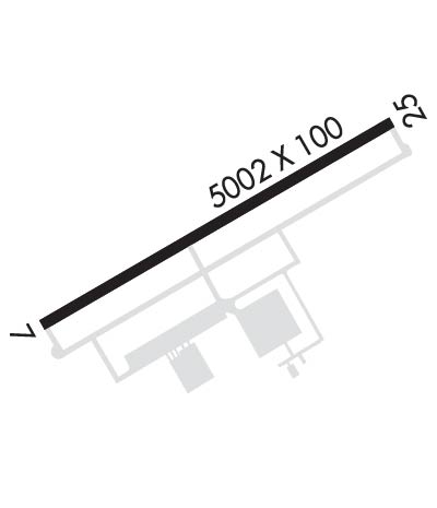
| Rwy | Rwy | |||||||
| 5002x100 | 5002' | 111.70 - 073° | 5002x100 | 5002' | ||||
| Runway ID | Single Wheel | Double Wheel | Double Tandem Wheel | Dual Double Wheel |
| 07/25 | 80,000 | 110,000 | 180,000 | N/A |
| These numbers are Advisory and are not limits. The Airport Manager should have more accurate Weight Limits | ||||
 Airport Diagram might not be current. | |
| Facility Name: | LORAIN COUNTY RGNL |
| City Name: | LORAIN/ELYRIA |
| County: | LORAIN |
| State abbrev: | OH |
| State Name: | OHIO |
| Ownership: | PUBLICLY OWNED |
| Use: | OPEN TO THE PUBLIC |
| Owner's Name: | LORAIN CO BOARD OF COMMISSIONERS |
| Address: | 44050 RUSSIA RD |
| ELYRIA, OH 44035 | |
| Owner's Phone: | 440-329-5000 |
| Manager's Name: | DOUG MCCONNELL C/O MRK AVIATION |
| Address: | 44050 RUSSIA RD |
| ELYRIA, OH 44035 | |
| Phone: | 440-323-7000; APT MGR CELL PHONE 216-389-6042 OR 330-721-8142 |
| FAA Region: | GREAT LAKES |
| FAA Field Office: | DET |
| Date | Sunrise | Sunset |
|---|---|---|
| 04/24/24 Wednesday | 6:35 | 20:20 |
| 04/25/24 Thursday | 6:33 | 20:21 |
| 04/26/24 Friday | 6:32 | 20:22 |
| 04/27/24 Saturday | 6:30 | 20:23 |
| 04/28/24 Sunday | 6:29 | 20:24 |
| 04/29/24 Monday | 6:28 | 20:25 |
| 04/30/24 Tuesday | 6:26 | 20:26 |
| 05/01/24 Wednesday | 6:25 | 20:27 |
| 05/02/24 Thursday | 6:24 | 20:28 |
| 05/03/24 Friday | 6:23 | 20:29 |
| 05/04/24 Saturday | 6:21 | 20:30 |
| 05/05/24 Sunday | 6:20 | 20:31 |
| 05/06/24 Monday | 6:19 | 20:32 |
| 05/07/24 Tuesday | 6:18 | 20:33 |
| Airport Attendance Schedule | APR-OCT 7 Days A Week 0700-2200, NOV-MAR 7 Days A Week 0700-2100 |
| Airport Status | OPERATIONAL (This Status can change at any time - please check NOTAMS) |
| Airport Lighting Schedule | HIRL RWY 07/25 PRESET LOW INTST, TO INCR INTST & ACTVT MALSR RWY 07; REIL RWY 25 - CTAF. |
| Airport Storage Available | Tie Downs, Hanger |
| Extra Services Available | Avionics, Cargo Handling, Charter, Flight Instruction, Aircraft Rental, Aircraft Sales |
| Wind Indicator | YES - (lighted) |
| Control Tower | NO |
| CTAF Frequency | 122.700 |
| Unicom Frequency | 122.700 |
| Rotating Beacon Color | WG |
| Segmented Circle | Y-L |
| Landing Fee | YES |
| Airport Inspected | FEDERAL - performed by STATE AERONAUTICAL PERSONNEL |
| Inspection Date | 09/28/2022 |
| Type of Fuel Available | Grade 100LL, JET A (freeze point -40C) |
| Airframe Repair Service | MAJOR |
| Power Plant Repair Service | MAJOR |
| Latitude | N4120.7 |
| Longitude | W08210.7 (ESTIMATED) |
| Arpt Elevation | 793ft (SURVEYED) |
| Magnetic Variation | 08W |
| 6 miles S | of LORAIN/ELYRIA |
| Traffic Pattern Altitude | |
| Sectional Chart | DETROIT |
| Operations (Reported) | Yearly | Avg. Daily |
|---|---|---|
| General Aviation Transient | 3529 | 10 |
| General Aviation Local | 16915 | 46 |
| Air Taxi | 1329 | 4 |
| Commerical | 0 | 0 |
| Commuter | 0 | 0 |
| Military | 0 | 0 |
| Aircraft based on Field | |
|---|---|
| General Aviation Singles | 75 |
| General Aviation Multi | 10 |
| Jet Aircraft | 1 |
| General Aviation Helicopters | 3 |
| Military Aircraft | 0 |
| Gliders | 1 |
| Ultralights | 0 |
| FSS on field | NO |
| FSS tie-in | CLEVELAND |
| FSS Phone | 1-800-WX-BRIEF |
| Who issues Notams | LPR |
| Notam D service at airport | YES |
| ARTCC Name | CLEVELAND |
| Airport Certification | |
| Aircraft Rescue & Firefighting Index | None |
| Airport of Entry | No |
| Custom Landing Rights | No |
| Joint Civil/Military | No |
| Military Landing rights | YES |
| NATIONAL PLAN OF INTEGRATED AIRPORT SYSTEMS (NPIAS) |
| GRANT AGREEMENTS UNDER FAAP/ADAP/AIP |
| ASSURANCES PURSUANT TO TITLE VI, CIVIL RIGHTS ACT OF 1964 |
| THIS AIRPORT HAS BEEN SURVEYED BY THE NATIONAL GEODETIC SURVEY. |
| PILOTS OPERG IN OBERLIN AREA REQD TO AVOID & RMN WELL CLR OF OBERLIN COLLEGE DUE TO MUSIC CONSERVATORY; ALL TFC OPNS NORTH OF ARPT AS PER FAR PART 93 SUBPART J. |
| DEER, BIRDS & OTHER WILDLIFE ON & INVOF ARPT. |
| FOR CD CTC CLEVELAND APCH AT 216-352-2323. |
Airport Communications & Frequencies:
| ||||||||||||||||
| Runway: 07 | Runway: 25 | ||
| Mag heading: | 73° | Mag heading: | 253° |
| Rwy Slope: | -.12% Down | Rwy Slope: | .12% Up |
| Approach: | ILS | Approach: | |
| Pattern: | Left Traffic | Pattern: | Right Traffic |
| Markings: | PRECISION INSTRUMENT | Markings: | NONPRECISION INSTRUMENT |
| Marking Condition: | FAIR | Marking Condition: | FAIR |
| Arresting Dev: | Arresting Dev: | ||
| Lat & Long: | N4120.5 W08211.2 | Lat. & Long.: | N4120.8 W08210.2 |
| Elev: | 793.2 ft. MSL | Elev: | 787.0 ft. MSL |
| TCH: | 52 ft. AGL | TCH: | 40 ft. AGL |
| Visual Glide Path: | 3.00 degrees | Visual Glide Path: | 3.00 degrees |
| Displaced Threshold: | No | Displaced Threshold: | No |
| Touchdown Zone: | YES | Touchdown Zone: | YES |
| Touchdown Elev.: | 793.2 feet | Touchdown Elev.: | 790.7 feet |
| Visual Glide Slope: | 4-Light PAPI on LEFT side of Runway | Visual Glide Slope: | 4-Light PAPI on LEFT side of Runway |
| RVR Equipment: | RVR Equipment: | ||
| RVV Equipment: | NO | RVV Equipment: | NO |
| Approach Lights: | MALSR - 1,400 foot medium intensity approach lighting system with runway alignment indicator lights | Approach Lights: | |
| REIL: | NO | REIL: | YES |
| Centerline Lights: | NO | Centerline Lights: | NO |
| Touchdown lights: | NO | Touchdown lights: | NO |
| Runway Category: | Precision Instrument Runway | Runway Category: | Runway with a Visual Approach |
| Declared Distances: | Declared Distances: |
