
| ||||||
| ||||||
|
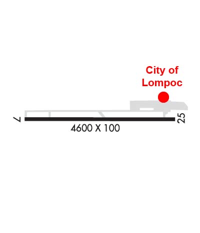
| Rwy | Rwy | |||||||
| 4600x100 | 4600' | 4600x100 | 4482' | |||||
| Runway ID | Single Wheel | Double Wheel | Double Tandem Wheel | Dual Double Wheel |
| 07/25 | 17,000 | N/A | N/A | N/A |
| These numbers are Advisory and are not limits. The Airport Manager should have more accurate Weight Limits | ||||
 Airport Diagram might not be current. | |
| Facility Name: | LOMPOC |
| City Name: | LOMPOC |
| County: | SANTA BARBARA |
| State abbrev: | CA |
| State Name: | CALIFORNIA |
| Ownership: | PUBLICLY OWNED |
| Use: | OPEN TO THE PUBLIC |
| Owner's Name: | CITY OF LOMPOC |
| Address: | 100 CIVIC CENTER PLAZA |
| LOMPOC, CA 93436-8001 | |
| Owner's Phone: | 805-875-8268 |
| Manager's Name: | RICHARD FERNBAUGH |
| Address: | CITY OF LOMPOC, 100 CIVIC CENTER PLAZA |
| LOMPOC, CA 93436-8001 | |
| Phone: | 805-875-8268 |
| FAA Region: | WESTERN-PACIFIC |
| FAA Field Office: | LAX |
| Date | Sunrise | Sunset |
|---|---|---|
| 04/24/24 Wednesday | 6:18 | 19:42 |
| 04/25/24 Thursday | 6:17 | 19:43 |
| 04/26/24 Friday | 6:16 | 19:43 |
| 04/27/24 Saturday | 6:15 | 19:44 |
| 04/28/24 Sunday | 6:14 | 19:45 |
| 04/29/24 Monday | 6:13 | 19:46 |
| 04/30/24 Tuesday | 6:12 | 19:47 |
| 05/01/24 Wednesday | 6:11 | 19:47 |
| 05/02/24 Thursday | 6:10 | 19:48 |
| 05/03/24 Friday | 6:09 | 19:49 |
| 05/04/24 Saturday | 6:08 | 19:50 |
| 05/05/24 Sunday | 6:07 | 19:51 |
| 05/06/24 Monday | 6:06 | 19:51 |
| 05/07/24 Tuesday | 6:05 | 19:52 |
| Airport Attendance Schedule | 7 Days A Week 0800-1700; ATNDD BY FBO, PHONE 805-717-3558. |
| Airport Status | OPERATIONAL (This Status can change at any time - please check NOTAMS) |
| Airport Lighting Schedule | ACTVT REIL RWY 25; MIRL RWY 07/25 - CTAF. PAPI RWY 25 ON CONSLY. |
| Airport Storage Available | Tie Downs |
| Extra Services Available | Crop Dusting, Flight Instruction, Aircraft Rental |
| Wind Indicator | YES - (lighted) |
| Control Tower | NO |
| CTAF Frequency | 122.700 |
| Unicom Frequency | 122.700 |
| Rotating Beacon Color | WG |
| Segmented Circle | YES |
| Landing Fee | NO |
| Airport Inspected | STATE - performed by STATE AERONAUTICAL PERSONNEL |
| Inspection Date | 10/16/2023 |
| Type of Fuel Available | Grade 100LL, JET A (freeze point -40C); -10FUEL AVBL 24 HRS; SELF-SERVICE CREDIT CARD ONLY. |
| Airframe Repair Service | MAJOR |
| Power Plant Repair Service | MAJOR |
| Latitude | N3439.9 |
| Longitude | W12028.1 (ESTIMATED) |
| Arpt Elevation | 88ft (ESTIMATED) |
| Magnetic Variation | 15E |
| 2 miles N | of LOMPOC |
| Traffic Pattern Altitude | 813 |
| Sectional Chart | LOS ANGELES |
| Operations (Reported) | Yearly | Avg. Daily |
|---|---|---|
| General Aviation Transient | 15000 | 41 |
| General Aviation Local | 15000 | 41 |
| Air Taxi | 0 | 0 |
| Commerical | 0 | 0 |
| Commuter | 0 | 0 |
| Military | 0 | 0 |
| Aircraft based on Field | |
|---|---|
| General Aviation Singles | 41 |
| General Aviation Multi | 1 |
| Jet Aircraft | 0 |
| General Aviation Helicopters | 0 |
| Military Aircraft | 0 |
| Gliders | 0 |
| Ultralights | 0 |
| FSS on field | NO |
| FSS tie-in | HAWTHORNE |
| FSS Phone | 1-800-WX-BRIEF |
| Who issues Notams | LPC |
| Notam D service at airport | YES |
| ARTCC Name | LOS ANGELES |
| Airport Certification | |
| Aircraft Rescue & Firefighting Index | None |
| Airport of Entry | No |
| Custom Landing Rights | No |
| Joint Civil/Military | No |
| Military Landing rights | YES |
| NATIONAL PLAN OF INTEGRATED AIRPORT SYSTEMS (NPIAS) |
| GRANT AGREEMENTS UNDER FAAP/ADAP/AIP |
| CONVEYANCE UNDER SCETION 16, FEDERAL AIRPORT ACT OF 1946 OR SECTION 23, AIRPORT AND AIRWAY DEVELOPMENT ACT OF 1970 |
| ASSURANCES PURSUANT TO TITLE VI, CIVIL RIGHTS ACT OF 1964 |
| DEER ON & INVOF ARPT. |
| ULTRALIGHT, AND SKY DIVING ACTIVITY INVOF OF ARPT DALGT HRS FRI-SUN. |
| FOR CD CTC LOS ANGELES ARTCC AT 661-575-2079. |
| TWY LGTS OTS UFN. |
Airport Communications & Frequencies:
| |||||||||||||||||
| Runway: 07 | Runway: 25 | ||
| Mag heading: | 76° | Mag heading: | 256° |
| Rwy Slope: | .20% Up | Rwy Slope: | -.20% Down |
| Approach: | Approach: | ||
| Pattern: | Left Traffic | Pattern: | Right Traffic |
| Markings: | NONPRECISION INSTRUMENT | Markings: | NONPRECISION INSTRUMENT |
| Marking Condition: | GOOD | Marking Condition: | GOOD |
| Arresting Dev: | Arresting Dev: | ||
| Lat & Long: | N3439.9 W12028.5 | Lat. & Long.: | N3439.9 W12027.6 |
| Elev: | 79.0 ft. MSL | Elev: | 88.1 ft. MSL |
| TCH: | TCH: | 25 ft. AGL | |
| Visual Glide Path: | Visual Glide Path: | 3.25 degrees | |
| Displaced Threshold: | No | Displaced Threshold: | 118 feet |
| Touchdown Zone: | YES | Touchdown Zone: | YES |
| Touchdown Elev.: | 80.0 feet | Touchdown Elev.: | 87.7 feet |
| Visual Glide Slope: | Visual Glide Slope: | 4-Light PAPI on LEFT side of Runway | |
| RVR Equipment: | RVR Equipment: | ||
| RVV Equipment: | NO | RVV Equipment: | NO |
| Approach Lights: | Approach Lights: | ||
| REIL: | NO | REIL: | YES |
| Centerline Lights: | NO | Centerline Lights: | NO |
| Touchdown lights: | NO | Touchdown lights: | NO |
| Runway Category: | Runway with a Visual Approach | Runway Category: | Runway with a Non-precision Approach |
| Declared Distances: | Declared Distances: | ||
| Obstructions: | BRUSH | Obstructions: | PLINE |
| Marked: | NOT Marked/Lighted | Marked: | MARKED |
| Clearance slope: | 20:1 | Clearance slope: | 34:1 |
| Obstruction height: | 25 feet AGL | Obstruction height: | 25 feet AGL |
| Dist. from runway: | 720 feet | Dist. from runway: | 1050 feet |
| Centerline offset: | Centerline offset: | ||
| Comments: | Comments: |