Click here for more info on on SMS!

KLOZ

LONDON-CORBIN ARPT-MAGEE FLD
LONDON
KY
Time Zone: Eastern
Lat: N 3705.2
Long: W 08404.6
Elev: 1212
Var: +05
Longest Runway: 5751
AWOS: 119.07
CTAF: 123.0

FBO & Flight Services info for KLOZ

FBOs: Update your Fuel Prices

LONDON CORBIN APTPh: 606-878-9100 Fax: 606-878-9101 Freq: 123.0
Service
Jet
100LL
SAF
MoGas
Fuel Avail: PRIST PREMIXED full serve avail. Mon-Fri 7:00 am-7:00 pm / Sat-Sun 8am-8pm Self Serve 24 Hours
Full4.505.30    Last Update: 04/05/2024 16:01

Self4.305.20    
 Address: 566 HAL ROGERS DR   LONDON, KY 40744
ASOSPh: 606-877-1699
-
Freq: 119.07  
If you are an FBO, call 1-203-262-1700 to update your info or email: FltPlan.Advertising@garmin.com
Advertise your FBO on FltPlan.com

Runway & Approach Info for KLOZ
Rwy
Length
Land Dist**
Approach*
  Rwy
Length
Land Dist**
Approach*
06
5751x150  5651'          
ILS/DME
 110.90 - 057°  
  
24
  5751x150  5201'          
 
 * only ILS, LOC, LDA, and SDF approaches to a specific runway are shown
** For any Declared Landing Distance Available, please see A/FD or Approach plates
Runway Weight Capability (lbs.) Help
Runway IDSingle WheelDouble WheelDouble Tandem WheelDual Double Wheel
06/2461,00082,000151,000N/A
These numbers are Advisory and are not limits.   The Airport Manager should have more accurate Weight Limits
Approach Charts
Approaches    
Current Weather/Notams
Customs Information Send updates to Support@FltPlan.com
Customs Not Available
Database effective 04/18/2024
Airport Diagram of KLOZ
Airport Diagram might not be current.

Facility Name: LONDON/CORBIN/MAGEE
City Name: LONDON
County: LAUREL
State abbrev: KY
State Name: KENTUCKY
   
Ownership: PUBLICLY OWNED
Use: OPEN TO THE PUBLIC
Owner's Name: CITIES OF LONDON & CORBIN
Address: 566 HAL ROGERS DRIVE
 LONDON, KY 40744
Owner's Phone: 606-878-9100
  
Manager's Name: MATTHEW SINGER
Address: 566 HAL ROGERS DRIVE
 LONDON, KY 40744
Phone: (606) 878-9100
   
FAA Region: SOUTHERN
FAA Field Office: MEM


Sunrise / Sunset times for LONDON/CORBIN/MAGEE

DateSunriseSunset
04/17/24 Wednesday6:5820:14
04/18/24 Thursday6:5720:15
04/19/24 Friday6:5620:15
04/20/24 Saturday6:5420:16
04/21/24 Sunday6:5320:17
04/22/24 Monday6:5220:18
04/23/24 Tuesday6:5020:19
04/24/24 Wednesday6:4920:20
04/25/24 Thursday6:4820:21
04/26/24 Friday6:4720:22
04/27/24 Saturday6:4620:23
04/28/24 Sunday6:4420:24
04/29/24 Monday6:4320:24
04/30/24 Tuesday6:4220:25

Airport Facilities

Airport Attendance ScheduleAPR-OCT MON-FRI 0700-2000, APR-OCT SAT-SUN 0800-2000, NOV-MAR MON-FRI 0700-1900, NOV-MAR SAT-SUN 0800-1900
Airport Status OPERATIONAL (This Status can change at any time - please check NOTAMS)
Airport Lighting ScheduleACTVT REIL RWY 06 & 24; MIRL RWY 06/24 - CTAF. PAPI RWY 06 & 24 OPR CONSLY.
Airport Storage AvailableTie Downs, Hanger
Extra Services AvailableAir Ambulance, Cargo Handling, Flight Instruction, Aircraft Rental
Wind IndicatorYES - (unlit)
Control TowerNO
CTAF Frequency123.000
Unicom Frequency123.000
Rotating Beacon ColorWG
Segmented CircleYES
Landing FeeNO

Airport Inspection Data

Airport InspectedSTATE - performed by STATE AERONAUTICAL PERSONNEL
Inspection Date09/01/2022

Airport Services

Type of Fuel AvailableGrade 100LL, JET A
Airframe Repair ServiceMAJOR
Power Plant Repair ServiceMAJOR

Geographic Data

LatitudeN3705.2
LongitudeW08404.6 (ESTIMATED)
Arpt Elevation1212ft (SURVEYED)
Magnetic Variation05W
3 miles Sof LONDON
Traffic Pattern Altitude
Sectional ChartCINCINNATI

Aircraft Data

Operations (Reported)YearlyAvg. Daily
General Aviation Transient 28528
General Aviation Local 868024
Air Taxi 404211
Commerical 00
Commuter 00
Military 1345437
Aircraft based on Field
General Aviation Singles 33
General Aviation Multi 1
Jet Aircraft 1
General Aviation Helicopters 4
Military Aircraft 0
Gliders 1
Ultralights 0

FAA Services

FSS on field NO
FSS tie-in LOUISVILLE
FSS Phone 1-800-WX-BRIEF
Who issues Notams LOZ
Notam D service at airport YES
ARTCC Name INDIANAPOLIS

Federal Status

Airport Certification
Aircraft Rescue & Firefighting IndexNone
Airport of EntryNo
Custom Landing RightsNo
Joint Civil/MilitaryNo
Military Landing rightsYES

Federal Agreements

NATIONAL PLAN OF INTEGRATED AIRPORT SYSTEMS (NPIAS)
GRANT AGREEMENTS UNDER FAAP/ADAP/AIP
ASSURANCES PURSUANT TO TITLE VI, CIVIL RIGHTS ACT OF 1964

Remarks

THIS AIRPORT HAS BEEN SURVEYED BY THE NATIONAL GEODETIC SURVEY.
FOR CD IF UNA TO CTC ON FSS FREQ, CTC INDIANAPOLIS ARTCC AT 317-247-2411.
RWY 06/2 4 TREES SW END OF RWY BOTH SIDES VIOLATES 7:1 TRSN SFC.
Airport Communications & Frequencies:
CTAF Frequency:
123.000
Unicom Frequency:
123.000
Remarks
  • APCH/DEP SVC PRVDD BY INDIANAPOLIS ARTCC ON FREQS 124.625/371.925 (LONDON 2 RCAG).
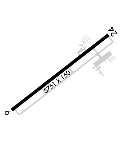
  • Runway Identifications
    Runway Identification: 06/24
    Length: 5751 ft
    Width: 150 ft
    Surface: ASPHALT-GOOD CONDITION
    Edge lights: Medium Intensity

    Treatment: NONE
    Weight: PCN 23 /F/C/X/T

     Runway: 06   Runway: 24
    Mag heading: 57°Mag heading: 237°
    Rwy Slope: -.52% DownRwy Slope: .52% Up
    Approach: ILS/DMEApproach:
    Pattern: Left TrafficPattern: Left Traffic
    Markings: PRECISION INSTRUMENTMarkings: NONPRECISION INSTRUMENT
    Marking Condition: GOODMarking Condition: GOOD
    Arresting Dev: Arresting Dev:
    Lat & Long: N3704.9  W08405.1Lat. & Long.: N3705.5  W08404.2
    Elev: 1212.3 ft. MSLElev: 1182.3 ft. MSL
    TCH: 52 ft. AGLTCH: 73 ft. AGL
    Visual Glide Path: 3.00 degreesVisual Glide Path: 4.00 degrees
    Displaced Threshold: 100 feetDisplaced Threshold: 550 feet
    Touchdown Zone: YESTouchdown Zone: YES
    Touchdown Elev.: 1211.9 feetTouchdown Elev.: 1200.5 feet
    Visual Glide Slope: 4-Light PAPI on LEFT side of RunwayVisual Glide Slope: 4-Light PAPI on LEFT side of Runway
    RVR Equipment: RVR Equipment:
    RVV Equipment: NORVV Equipment: NO
    Approach Lights: Approach Lights:
    REIL: YES; THR LGTS NON STD.REIL: YES
    Centerline Lights: NOCenterline Lights: NO
    Touchdown lights: NOTouchdown lights: NO
    Runway Category: Precision Instrument RunwayRunway Category: Runway with a Non-precision Approach having visibility minimums greater than 3/4 mile
    Declared Distances: TORA:5750' TODA:5750' ASDA:5100' LDA:5000'Declared Distances: TORA:5750' TODA:5750' ASDA:5750' LDA:5200'
    Obstructions: TREEObstructions: TREE
    Marked: NOT Marked/LightedMarked: NOT Marked/Lighted
    Clearance slope: 11:1; APCH SLOPE 16:1 TO DTHR.Clearance slope: 3:1
    Obstruction height: 61 feet AGLObstruction height: 29 feet AGL
    Dist. from runway: 900 feetDist. from runway: 292 feet
    Centerline offset: 610 right of centerlineCenterline offset: 318 feet right of centerline
    Comments: Comments:
    C:10/P: