KLOM

WINGS FIELD
PHILADELPHIA
PA
Time Zone: Eastern
Lat: N 4008.3
Long: W 07515.9
Elev: 302
Var: +12
Longest Runway: 3700
Clr Del: 118.55
AWOS: 118.92
CTAF: 123.0

FBO & Flight Services info for KLOM

FBOs: Update your Fuel Prices

FLY ADVANCEDPh: 215-646-0400
-
Freq: 123.0
Service
Jet
100LL
SAF
MoGas
Fuel Avail: PRIST+ $0.05/gal. 0600-2200 daily, after hours an service requests text 215-515-7356
Full7.707.70    Last Update: 04/15/2024 11:21

Self        
 Address: 1501 NARCISSA RD,   BLUE BELL, PA 19422
AWOSPh: 215-646-1068
-
Freq: 118.92  
If you are an FBO, call 1-203-262-1700 to update your info or email: FltPlan.Advertising@garmin.com
Advertise your FBO on FltPlan.com

Runway & Approach Info for KLOM
Rwy
Length
Land Dist**
Approach*
  Rwy
Length
Land Dist**
Approach*
06
3700x75  3523'          
 
  
24
  3700x75  3700'          
 
 * only ILS, LOC, LDA, and SDF approaches to a specific runway are shown
** For any Declared Landing Distance Available, please see A/FD or Approach plates
Runway Weight Capability (lbs.) Help
Runway IDSingle WheelDouble WheelDouble Tandem WheelDual Double Wheel
06/2412,500N/AN/AN/A
These numbers are Advisory and are not limits.   The Airport Manager should have more accurate Weight Limits
Approach Charts
Approaches    
Current Weather/Notams
Customs Information Send updates to Support@FltPlan.com
Customs Not Available
Database effective 04/18/2024
Airport Diagram of KLOM
Airport Diagram might not be current.

Facility Name: WINGS FLD
City Name: PHILADELPHIA
County: MONTGOMERY
State abbrev: PA
State Name: PENNSYLVANIA
   
Ownership: PRIVATELY OWNED
Use: OPEN TO THE PUBLIC
Owner's Name: WINGS FIELD PRESERVATION ASSOC
Address: 1501 NARCISSA RD
 BLUE BELL, PA 19422
Owner's Phone: (215) 646-0400
  
Manager's Name: JOSEPH DISIPIO
Address: 1501 NARCISSA RD
 BLUE BELL, PA 19422
Phone: 215-646-0400; ALT CTC: 215-515-7356; LOMFRONTDESK@FLYADVANCED.COM
   
FAA Region: EASTERN
FAA Field Office: HAR


Sunrise / Sunset times for WINGS FLD

DateSunriseSunset
04/18/24 Thursday6:1819:44
04/19/24 Friday6:1619:45
04/20/24 Saturday6:1519:46
04/21/24 Sunday6:1319:47
04/22/24 Monday6:1219:48
04/23/24 Tuesday6:1019:49
04/24/24 Wednesday6:0919:50
04/25/24 Thursday6:0819:51
04/26/24 Friday6:0619:52
04/27/24 Saturday6:0519:53
04/28/24 Sunday6:0419:54
04/29/24 Monday6:0219:55
04/30/24 Tuesday6:0119:56
05/01/24 Wednesday6:0019:57

Airport Facilities

Airport Attendance Schedule7 Days A Week 0600-2200
Airport Status OPERATIONAL (This Status can change at any time - please check NOTAMS)
Airport Lighting ScheduleDUSK-DAWN. ACTIVATE MIRL RYS 06/24, PAPI & REIL RYS 06 & 24 - CTAF
Airport Storage AvailableTie Downs, Hanger
Extra Services AvailableAir Ambulance, Charter, Flight Instruction, Aircraft Rental, Aircraft Sales
Wind IndicatorYES - (lighted)
Control TowerNO
CTAF Frequency123.000
Unicom Frequency123.000
Rotating Beacon ColorWG
Segmented CircleYES
Landing FeeNO

Airport Inspection Data

Airport InspectedSTATE - performed by STATE AERONAUTICAL PERSONNEL
Inspection Date09/14/2022

Airport Services

Type of Fuel AvailableGrade 100LL, JET A (freeze point -40C)
Airframe Repair ServiceMAJOR
Power Plant Repair ServiceMAJOR

Geographic Data

LatitudeN4008.3
LongitudeW07515.9 (ESTIMATED)
Arpt Elevation301ft (SURVEYED)
Magnetic Variation12W
3 miles NWof PHILADELPHIA
Traffic Pattern Altitude
Sectional ChartNEW YORK

Aircraft Data

Operations (Reported)YearlyAvg. Daily
General Aviation Transient 1217033
General Aviation Local 2522969
Air Taxi 713620
Commerical 00
Commuter 00
Military 650
Aircraft based on Field
General Aviation Singles 75
General Aviation Multi 11
Jet Aircraft 5
General Aviation Helicopters 2
Military Aircraft 0
Gliders 0
Ultralights 0

FAA Services

FSS on field NO
FSS tie-in WILLIAMSPORT
FSS Phone 1-800-WX-BRIEF
Who issues Notams LOM
Notam D service at airport YES
ARTCC Name NEW YORK

Federal Status

Airport Certification
Aircraft Rescue & Firefighting IndexNone
Airport of EntryNo
Custom Landing RightsNo
Joint Civil/MilitaryNo
Military Landing rightsNo

Federal Agreements

NATIONAL PLAN OF INTEGRATED AIRPORT SYSTEMS (NPIAS)

Remarks

FOR CD CTC PHILADELPHIA APCH AT 800-354-9884.
RWY 6/24 NO TGLS.
NOISE ABATEMENT RYS 06 & 24 - NO TURNS AFTER TKOF BEFORE 1000 FT AGL. AVOID OVERFLIGHT OF SCHOOLS EAST & WEST OF ARPT.
LARGE FLOCKS OF GEESE ON & INVOF ARPT.
DEER ON & INVOF ARPT.
FOR SVC AFTER HRS CTC AMGR BY PHONE OR EMAIL.
PPR ALL ACFT EXCEEDING 12,500 LBS TKOF GROS WEIGHT OR ABOVE CALL 215-646-0400.
Airport Communications & Frequencies:
Clearance Delivery Frequencies:
118.55
CTAF Frequency:
123.000
Unicom Frequency:
123.000
Remarks
  • CLEARANCE DELIVERY PHILADELPHIA APCH TF 800-354-9884.
  • PHILADELPHIA Primary Approach Frequencies:  
    126.85
    263.125
    PHILADELPHIA Primary Departure Frequencies:  
    126.85
    263.125
    Runway Identifications
    Runway Identification: 06/24
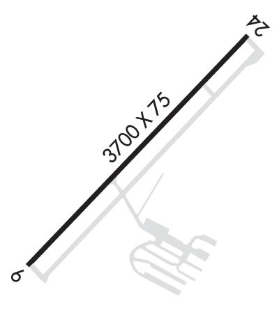
    Length: 3700 ft
    Width: 75 ft
    Surface: ASPHALT-GOOD CONDITION
    Edge lights: Medium Intensity

    Treatment: NONE

     Runway: 06   Runway: 24
    Mag heading: 65°Mag heading: 245°
    Rwy Slope: -.62% DownRwy Slope: .62% Up
    Approach: Approach:
    Pattern: Left TrafficPattern: Left Traffic
    Markings: NONPRECISION INSTRUMENTMarkings: NONPRECISION INSTRUMENT
    Marking Condition: GOODMarking Condition: GOOD
    Arresting Dev: Arresting Dev:
    Lat & Long: N4008.1  W07516.2Lat. & Long.: N4008.4  W07515.6
    Elev: 301.5 ft. MSLElev: 278.7 ft. MSL
    TCH: 40 ft. AGLTCH: 40 ft. AGL
    Visual Glide Path: 3.00 degreesVisual Glide Path: 3.00 degrees
    Displaced Threshold: 177 feetDisplaced Threshold: No
    Touchdown Zone: YESTouchdown Zone: YES
    Touchdown Elev.: 300.8 feetTouchdown Elev.: 295.3 feet
    Visual Glide Slope: 2-Light PAPI on LEFT side of RunwayVisual Glide Slope: 2-Light PAPI on LEFT side of Runway
    RVR Equipment: RVR Equipment:
    RVV Equipment: NORVV Equipment: NO
    Approach Lights: Approach Lights:
    REIL: YESREIL: YES
    Centerline Lights: NOCenterline Lights: NO
    Touchdown lights: NOTouchdown lights: NO
    Runway Category: Runway with a Non-precision ApproachRunway Category: Runway with a Non-precision Approach
    Declared Distances: Declared Distances:
    Obstructions: POLEObstructions: TREES
    Marked: NOT Marked/LightedMarked: NOT Marked/Lighted
    Clearance slope: 2:1; APCH SLOPE 22:1 TO DSPLCD THLD.Clearance slope: 9:1
    Obstruction height: 19 feet AGLObstruction height: 50 feet AGL
    Dist. from runway: 241 feetDist. from runway: 676 feet
    Centerline offset: 175 right of centerlineCenterline offset: 276 feet right of centerline
    Comments: ROAD 138 FT FM RWY END, ACRS CNTLRN. 22 FT POLE 169 FT FM RWY END 233 FT RIGHT. 32 FT OBST LT 77 FT FM RWY END 139 FT RIGHT. 17 FT OBS LT 56 FT FM RWY END 133 FT LEFT.Comments:
    C:26/P: