Current Weather/Notams (Metars, TAFs, Notams, NWS Forecast, PIREPS, and nearby weather)
Customs Information Send updates to Support@FltPlan.com
Customs Not Available
Database effective 05/16/2024
Airport Diagram might not be current.
|
| Facility Name: | DERBY FLD |
| City Name: | LOVELOCK |
| County: | PERSHING |
| State abbrev: | NV |
| State Name: | NEVADA |
| | |
| Ownership: | PUBLICLY OWNED |
| Use: | OPEN TO THE PUBLIC |
| Owner's Name: | PERSHING COUNTY |
| Address: | COUNTY CLERKS OFFICE, PO BOX 820 |
| | LOVELOCK, NV 89419 |
| Owner's Phone: | 775-273-2208 |
| | |
| Manager's Name: | LARRY RACKLEY; ASST MGR JOHN HANDKA 775-273-2342. |
| Address: | P. O. BOX DRAWER E |
| | LOVELOCK, NV 89419 |
| Phone: | 775-442-1975 |
| | |
| FAA Region: | WESTERN-PACIFIC |
| FAA Field Office: | PHX |
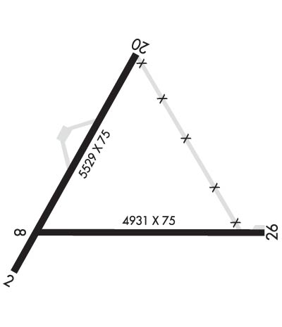
Runway Identifications
Runway Identification: 02/20Length: 5529 ft
Width: 75 ft
Surface: ASPHALT-GOOD CONDITION
Edge lights: Medium IntensityTreatment: NONE
| | Runway: 02 | | Runway: 20 |
| Mag heading: | 16° | Mag heading: | 196° |
| Rwy Slope: | .07% Up | Rwy Slope: | -.07% Down |
| Approach: | | Approach: | |
| Pattern: | Left Traffic | Pattern: | Left Traffic |
| Markings: | NONPRECISION INSTRUMENT | Markings: | NONPRECISION INSTRUMENT |
| Marking Condition: | GOOD | Marking Condition: | POOR |
| Arresting Dev: | | Arresting Dev: | |
| Lat & Long: | N4003.7 W11834.4 | Lat. & Long.: | N4004.5 W11833.8 |
| Elev: | 3903.1 ft. MSL | Elev: | 3907.2 ft. MSL |
| TCH: | 44 ft. AGL | TCH: | 45 ft. AGL |
| Visual Glide Path: | 3.00 degrees | Visual Glide Path: | 3.00 degrees |
| Displaced Threshold: | No | Displaced Threshold: | No |
| Touchdown Zone: | YES | Touchdown Zone: | YES |
| Touchdown Elev.: | 3905.6 feet | Touchdown Elev.: | 3907.6 feet |
| Visual Glide Slope: | 2-Light PAPI on LEFT side of Runway | Visual Glide Slope: | 2-Light PAPI on LEFT side of Runway |
| RVR Equipment: | | RVR Equipment: | |
| RVV Equipment: | NO | RVV Equipment: | NO |
| Approach Lights: | | Approach Lights: | |
| REIL: | YES | REIL: | YES |
| Centerline Lights: | NO | Centerline Lights: | NO |
| Touchdown lights: | NO | Touchdown lights: | NO |
| Runway Category: | Runway with a Non-precision Approach | Runway Category: | Runway with a Visual Approach |
| Declared Distances: | | Declared Distances: | |
| Obstructions: | | Obstructions: | FENCE |
| Marked: | | Marked: | NOT Marked/Lighted |
| Clearance slope: | 50:1 | Clearance slope: | 25:1 |
| Obstruction height: | | Obstruction height: | 4 feet AGL |
| Dist. from runway: | | Dist. from runway: | 300 feet |
| Centerline offset: | | Centerline offset: | |
| Comments: | | Comments: | |
Runway Identification: 08/26Length: 4931 ft
Width: 75 ft
Surface: ASPHALT-GOOD CONDITION
Edge lights: Treatment: NONE
| | Runway: 08 | | Runway: 26 |
| Mag heading: | 76° | Mag heading: | 256° |
| Rwy Slope: | -.01% Down | Rwy Slope: | .01% Up |
| Approach: | | Approach: | |
| Pattern: | Left Traffic | Pattern: | Left Traffic |
| Markings: | BASIC | Markings: | BASIC |
| Marking Condition: | GOOD | Marking Condition: | FAIR |
| Arresting Dev: | | Arresting Dev: | |
| Lat & Long: | N4003.9 W11834.2 | Lat. & Long.: | N4003.9 W11833.2 |
| Elev: | 3903.3 ft. MSL | Elev: | 3902.8 ft. MSL |
| TCH: | | TCH: | |
| Visual Glide Path: | | Visual Glide Path: | |
| Displaced Threshold: | No | Displaced Threshold: | 120 feet |
| Touchdown Zone: | YES | Touchdown Zone: | YES |
| Touchdown Elev.: | 3903.4 feet | Touchdown Elev.: | 3902.9 feet |
| Visual Glide Slope: | | Visual Glide Slope: | |
| RVR Equipment: | | RVR Equipment: | |
| RVV Equipment: | NO | RVV Equipment: | NO |
| Approach Lights: | | Approach Lights: | |
| REIL: | NO | REIL: | NO |
| Centerline Lights: | NO | Centerline Lights: | NO |
| Touchdown lights: | NO | Touchdown lights: | NO |
| Runway Category: | Runway with a Visual Approach | Runway Category: | Runway with a Visual Approach |
| Declared Distances: | | Declared Distances: | |
| Obstructions: | | Obstructions: | FENCE |
| Marked: | | Marked: | NOT Marked/Lighted |
| Clearance slope: | 50:1 | Clearance slope: | 10:1 |
| Obstruction height: | | Obstruction height: | 5 feet AGL |
| Dist. from runway: | | Dist. from runway: | 250 feet |
| Centerline offset: | | Centerline offset: | |
| Comments: | 3 FT BERM 175 FT FM EOR. | Comments: | |

