| ||||||||||||||||||||||||||||||||||||||||||||||||||||||||||||||||||||
| ||||||||||||||||||||||||||||||||||||||||||||||||||||||||||||||||||||
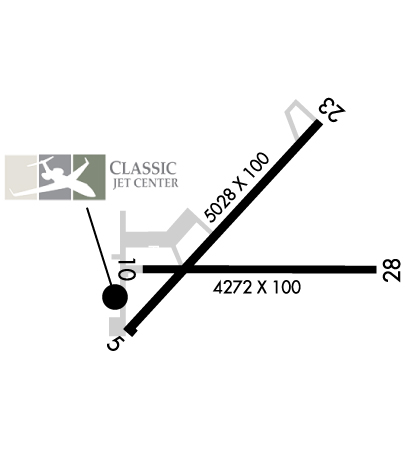
| Rwy | Rwy | |||||||
| 5028x100 | 4600' | 5028x100 | 5028' | |||||
| 4272x100 | 4272' | 4272x100 | 3148' | |||||
| Runway ID | Single Wheel | Double Wheel | Double Tandem Wheel | Dual Double Wheel |
| 05/23 | 68,000 | 80,000 | 124,000 | N/A |
| 10/28 | 68,000 | 80,000 | 124,000 | N/A |
| These numbers are Advisory and are not limits. The Airport Manager should have more accurate Weight Limits | ||||
 Airport Diagram might not be current. | |
| Facility Name: | LAKE COUNTY EXEC |
| City Name: | WILLOUGHBY |
| County: | LAKE |
| State abbrev: | OH |
| State Name: | OHIO |
| Ownership: | PUBLICLY OWNED |
| Use: | OPEN TO THE PUBLIC |
| Owner's Name: | LAKE DEVELOPMENT AUTHORITY |
| Address: | 105 N MAIN ST STE B501 |
| PAINESVILLE, OH 44077-3414 | |
| Owner's Phone: | 440-350-5342 |
| Manager's Name: | PATTY FULOP; PFULOP@LDAUTHORITY.ORG. |
| Address: | 38550 JET CENTER PL |
| WILLOUGHBY, OH 44094-8174 | |
| Phone: | 440-953-4372; CELL 440-321-9036. |
| FAA Region: | GREAT LAKES |
| FAA Field Office: | DET |
| Date | Sunrise | Sunset |
|---|---|---|
| 04/25/24 Thursday | 6:29 | 20:18 |
| 04/26/24 Friday | 6:28 | 20:19 |
| 04/27/24 Saturday | 6:27 | 20:20 |
| 04/28/24 Sunday | 6:25 | 20:21 |
| 04/29/24 Monday | 6:24 | 20:22 |
| 04/30/24 Tuesday | 6:23 | 20:23 |
| 05/01/24 Wednesday | 6:21 | 20:25 |
| 05/02/24 Thursday | 6:20 | 20:26 |
| 05/03/24 Friday | 6:19 | 20:27 |
| 05/04/24 Saturday | 6:17 | 20:28 |
| 05/05/24 Sunday | 6:16 | 20:29 |
| 05/06/24 Monday | 6:15 | 20:30 |
| 05/07/24 Tuesday | 6:14 | 20:31 |
| 05/08/24 Wednesday | 6:13 | 20:32 |
| Airport Attendance Schedule | 7 Days A Week 0700-2100; FOR ATTENDANT OR FUEL SER AFT HRS CALL 440-942-7092, 2300-0600 BY PRIOR ARNGMT ONLY. |
| Airport Status | OPERATIONAL (This Status can change at any time - please check NOTAMS) |
| Airport Lighting Schedule | ACTVT REIL RWY 05, 23, 10, & 28; MIRL RWY 05/23 & 10/28 - CTAF. PAPI RWY 05, 23, 10, & 28 OPR CONSLY. |
| Airport Storage Available | Tie Downs, Hanger |
| Extra Services Available | Charter, Flight Instruction, Aircraft Rental |
| Wind Indicator | YES - (lighted) |
| Control Tower | NO |
| CTAF Frequency | 122.725 |
| Unicom Frequency | 122.725 |
| Rotating Beacon Color | WG |
| Segmented Circle | YES |
| Landing Fee | YES; LDG FEE FOR ALL COML ACFT BY WEIGHT; MULTI-ENG & LRGR. |
| Airport Inspected | STATE - performed by STATE AERONAUTICAL PERSONNEL |
| Inspection Date | 10/05/2023 |
| Type of Fuel Available | Grade 100LL, JET A (freeze point -40C) |
| Airframe Repair Service | MAJOR |
| Power Plant Repair Service | MAJOR |
| Latitude | N4141.0 |
| Longitude | W08123.4 (ESTIMATED) |
| Arpt Elevation | 625ft (SURVEYED) |
| Magnetic Variation | 08W |
| 3 miles N | of WILLOUGHBY |
| Traffic Pattern Altitude | |
| Sectional Chart | DETROIT |
| Operations (Reported) | Yearly | Avg. Daily |
|---|---|---|
| General Aviation Transient | 18751 | 51 |
| General Aviation Local | 24762 | 68 |
| Air Taxi | 1547 | 4 |
| Commerical | 0 | 0 |
| Commuter | 0 | 0 |
| Military | 25 | 0 |
| Aircraft based on Field | |
|---|---|
| General Aviation Singles | 63 |
| General Aviation Multi | 11 |
| Jet Aircraft | 7 |
| General Aviation Helicopters | 1 |
| Military Aircraft | 0 |
| Gliders | 0 |
| Ultralights | 0 |
| FSS on field | NO |
| FSS tie-in | CLEVELAND |
| FSS Phone | 1-800-WX-BRIEF |
| Who issues Notams | CLE |
| Notam D service at airport | YES |
| ARTCC Name | CLEVELAND |
| Airport Certification | |
| Aircraft Rescue & Firefighting Index | None |
| Airport of Entry | No |
| Custom Landing Rights | No |
| Joint Civil/Military | No |
| Military Landing rights | No |
| NATIONAL PLAN OF INTEGRATED AIRPORT SYSTEMS (NPIAS) |
| GRANT AGREEMENTS UNDER FAAP/ADAP/AIP |
| ASSURANCES PURSUANT TO TITLE VI, CIVIL RIGHTS ACT OF 1964 |
| DEER, BIRDS, & OTR WILDLIFE ON & INVOF ARPT. |
| PAT WORK NA 2300-0800. |
| FOR CD CTC CLEVELAND APCH AT 216-352-2323. |
Airport Communications & Frequencies:
| ||||||||||||||
| Runway: 05 | Runway: 23 | ||
| Mag heading: | 53° | Mag heading: | 233° |
| Rwy Slope: | -.08% Down | Rwy Slope: | .08% Up |
| Approach: | Approach: | ||
| Pattern: | Left Traffic | Pattern: | Left Traffic |
| Markings: | NONPRECISION INSTRUMENT | Markings: | NONPRECISION INSTRUMENT |
| Marking Condition: | GOOD | Marking Condition: | GOOD |
| Arresting Dev: | Arresting Dev: | ||
| Lat & Long: | N4140.8 W08123.8 | Lat. & Long.: | N4141.4 W08123.1 |
| Elev: | 623.7 ft. MSL | Elev: | 619.5 ft. MSL |
| TCH: | 29 ft. AGL | TCH: | 54 ft. AGL |
| Visual Glide Path: | 3.50 degrees | Visual Glide Path: | 4.00 degrees |
| Displaced Threshold: | 428 feet | Displaced Threshold: | No |
| Touchdown Zone: | YES | Touchdown Zone: | YES |
| Touchdown Elev.: | 624.3 feet | Touchdown Elev.: | 623.2 feet |
| Visual Glide Slope: | 4-Light PAPI on RIGHT side of Runway | Visual Glide Slope: | 4-Light PAPI on LEFT side of Runway |
| RVR Equipment: | RVR Equipment: | ||
| RVV Equipment: | NO | RVV Equipment: | NO |
| Approach Lights: | Approach Lights: | ||
| REIL: | YES | REIL: | YES |
| Centerline Lights: | NO | Centerline Lights: | NO |
| Touchdown lights: | NO | Touchdown lights: | NO |
| Runway Category: | Runway with a Non-precision Approach having visibility minimums greater than 3/4 mile | Runway Category: | Runway with a Non-precision Approach having visibility minimums greater than 3/4 mile |
| Declared Distances: | Declared Distances: | ||
| Obstructions: | TREE | Obstructions: | TREES |
| Marked: | NOT Marked/Lighted | Marked: | NOT Marked/Lighted |
| Clearance slope: | 19:1; APCH SLP 24:1 TO DTHR OVR +98 FT TREE, 2372 FT DIST, 548 FT L. | Clearance slope: | 11:1 |
| Obstruction height: | 62 feet AGL | Obstruction height: | 98 feet AGL |
| Dist. from runway: | 1399 feet | Dist. from runway: | 1335 feet |
| Centerline offset: | 157 left of centerline | Centerline offset: | 341 feet right of centerline |
| Comments: | Comments: |
| Runway: 10 | Runway: 28 | ||
| Mag heading: | 99° | Mag heading: | 279° |
| Rwy Slope: | .01% Up | Rwy Slope: | -.01% Down |
| Approach: | Approach: | ||
| Pattern: | Left Traffic | Pattern: | Left Traffic |
| Markings: | NONPRECISION INSTRUMENT | Markings: | NONPRECISION INSTRUMENT |
| Marking Condition: | GOOD | Marking Condition: | GOOD |
| Arresting Dev: | Arresting Dev: | ||
| Lat & Long: | N4141.0 W08123.8 | Lat. & Long.: | N4140.9 W08122.8 |
| Elev: | 623.6 ft. MSL | Elev: | 624.1 ft. MSL |
| TCH: | 47 ft. AGL | TCH: | 26 ft. AGL |
| Visual Glide Path: | 3.50 degrees | Visual Glide Path: | 3.50 degrees |
| Displaced Threshold: | No | Displaced Threshold: | 1124 feet |
| Touchdown Zone: | YES | Touchdown Zone: | YES |
| Touchdown Elev.: | 625.0 feet | Touchdown Elev.: | 625.6 feet |
| Visual Glide Slope: | 2-Light PAPI on LEFT side of Runway | Visual Glide Slope: | 2-Light PAPI on LEFT side of Runway |
| RVR Equipment: | RVR Equipment: | ||
| RVV Equipment: | NO | RVV Equipment: | NO |
| Approach Lights: | Approach Lights: | ||
| REIL: | YES | REIL: | YES |
| Centerline Lights: | NO | Centerline Lights: | NO |
| Touchdown lights: | NO | Touchdown lights: | NO |
| Runway Category: | Runway with a Non-precision Approach | Runway Category: | Runway with a Non-precision Approach |
| Declared Distances: | Declared Distances: | ||
| Obstructions: | Obstructions: | TREES | |
| Marked: | Marked: | NOT Marked/Lighted | |
| Clearance slope: | 20:1 | Clearance slope: | 7:1; APCH SLP 10:1 TO DTHR OVR +89 FT TREES, 931 FT DIST, 329 FT L. |
| Obstruction height: | Obstruction height: | 68 feet AGL | |
| Dist. from runway: | Dist. from runway: | 738 feet | |
| Centerline offset: | Centerline offset: | 215 feet left of centerline | |
| Comments: | Comments: |