Current Weather/Notams (Metars, TAFs, Notams, NWS Forecast, PIREPS, and nearby weather)
Customs Information Send updates to Support@FltPlan.com
Customs Not Available
Database effective 05/16/2024
Airport Diagram might not be current.
|
| Facility Name: | KINGS LAND O' LAKES |
| City Name: | LAND O' LAKES |
| County: | VILAS |
| State abbrev: | WI |
| State Name: | WISCONSIN |
| | |
| Ownership: | PUBLICLY OWNED |
| Use: | OPEN TO THE PUBLIC |
| Owner's Name: | TOWN OF LAND O'LAKES |
| Address: | BOX 660 |
| | LAND O'LAKES, WI 54540 |
| Owner's Phone: | 715-547-3255 |
| | |
| Manager's Name: | BRUCE GARRISON |
| Address: | PO BOX 327 |
| | LAND O'LAKES, WI 54540 |
| Phone: | 715-547-3337 |
| | |
| FAA Region: | GREAT LAKES |
| FAA Field Office: | CHI |
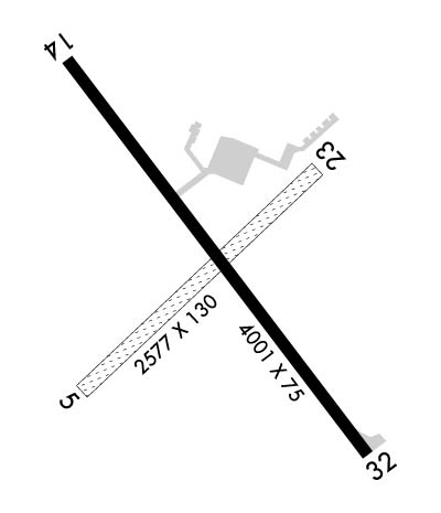
Runway Identifications
Runway Identification: 05/23Length: 2577 ft
Width: 130 ft
Surface: GRASS-FAIR CONDITION
Edge lights: Treatment: NONE
| | Runway: 05 | | Runway: 23 |
| Mag heading: | 52° | Mag heading: | 232° |
| Rwy Slope: | .29% Up | Rwy Slope: | -.29% Down |
| Approach: | | Approach: | |
| Pattern: | Left Traffic | Pattern: | Left Traffic |
| Markings: | | Markings: | |
| Marking Condition: | MKD WITH YELLOW CONES. | Marking Condition: | MKD WITH YELLOW CONES. |
| Arresting Dev: | | Arresting Dev: | |
| Lat & Long: | N4609.1 W08913.0 | Lat. & Long.: | N4609.4 W08912.5 |
| Elev: | 1696.8 ft. MSL | Elev: | 1704.4 ft. MSL |
| TCH: | | TCH: | |
| Visual Glide Path: | | Visual Glide Path: | |
| Displaced Threshold: | No | Displaced Threshold: | 589 feet |
| Touchdown Zone: | YES | Touchdown Zone: | YES |
| Touchdown Elev.: | 1705.0 feet | Touchdown Elev.: | 1703.0 feet |
| Visual Glide Slope: | | Visual Glide Slope: | |
| RVR Equipment: | | RVR Equipment: | |
| RVV Equipment: | NO | RVV Equipment: | NO |
| Approach Lights: | | Approach Lights: | |
| REIL: | NO | REIL: | NO |
| Centerline Lights: | NO | Centerline Lights: | NO |
| Touchdown lights: | NO | Touchdown lights: | NO |
| Runway Category: | Runway with a Visual Approach | Runway Category: | Runway with a Visual Approach |
| Declared Distances: | | Declared Distances: | |
| Obstructions: | TREES | Obstructions: | TREES |
| Marked: | NOT Marked/Lighted | Marked: | NOT Marked/Lighted |
| Clearance slope: | 1:1 | Clearance slope: | 5:1; APCH RATIO 16:1 TO DSPLCD THR; 94 FT TREES 1490 FT FM DSPLCD THR, 135 L. |
| Obstruction height: | 30 feet AGL | Obstruction height: | 48 feet AGL |
| Dist. from runway: | 0 feet | Dist. from runway: | 285 feet |
| Centerline offset: | 100 right of centerline | Centerline offset: | 120 feet left of centerline |
| Comments: | | Comments: | |
Runway Identification: 14/32Length: 4000 ft
Width: 75 ft
Surface: ASPHALT
Edge lights: Medium IntensityTreatment: NONE
| | Runway: 14 | | Runway: 32 |
| Mag heading: | 145° | Mag heading: | 325° |
| Rwy Slope: | -.04% Down | Rwy Slope: | .04% Up |
| Approach: | | Approach: | |
| Pattern: | Left Traffic | Pattern: | Left Traffic |
| Markings: | NONPRECISION INSTRUMENT | Markings: | NONPRECISION INSTRUMENT |
| Marking Condition: | GOOD | Marking Condition: | GOOD |
| Arresting Dev: | | Arresting Dev: | |
| Lat & Long: | N4609.5 W08913.0 | Lat. & Long.: | N4609.0 W08912.4 |
| Elev: | 1705.6 ft. MSL | Elev: | 1704.1 ft. MSL |
| TCH: | 40 ft. AGL | TCH: | 40 ft. AGL |
| Visual Glide Path: | 4.00 degrees | Visual Glide Path: | 3.00 degrees |
| Displaced Threshold: | 201 feet | Displaced Threshold: | 399 feet |
| Touchdown Zone: | YES | Touchdown Zone: | YES |
| Touchdown Elev.: | 1705.3 feet | Touchdown Elev.: | 1704.6 feet |
| Visual Glide Slope: | 2-Light PAPI on LEFT side of Runway | Visual Glide Slope: | 2-Light PAPI on LEFT side of Runway |
| RVR Equipment: | | RVR Equipment: | |
| RVV Equipment: | NO | RVV Equipment: | NO |
| Approach Lights: | | Approach Lights: | |
| REIL: | YES | REIL: | YES |
| Centerline Lights: | NO | Centerline Lights: | NO |
| Touchdown lights: | NO | Touchdown lights: | NO |
| Runway Category: | Runway with a Non-precision Approach | Runway Category: | Runway with a Non-precision Approach |
| Declared Distances: | | Declared Distances: | |
| Obstructions: | ROAD | Obstructions: | ROAD |
| Marked: | NOT Marked/Lighted | Marked: | LIGHTED |
| Clearance slope: | 1:1; APCH RATIO 20:1 TO DSPLCD THR. | Clearance slope: | 1:1 |
| Obstruction height: | 15 feet AGL | Obstruction height: | 18 feet AGL |
| Dist. from runway: | 200 feet | Dist. from runway: | 200 feet |
| Centerline offset: | 50 left of centerline | Centerline offset: | 245 feet right of centerline |
| Comments: | INTMT USE ROAD 0-200 FT FM RWY END, 50-100 FT L. | Comments: | ROAD 187 FT FM RWY END, 250 FT RIGHT. |

