Click here for more info on on SMS!

KLNK

LINCOLN
LINCOLN
NE
Time Zone: Central
Lat: N 4051.1
Long: W 09645.5
Elev: 1219
Var: -03
Longest Runway: 12901
Clr Del: 120.7
Dept. ATIS: 118.05
Arr. ATIS: 118.05
Ground: 121.9
Tower: 118.5/125.7

FBO & Flight Services info for KLNK

FBOs: Update your Fuel Prices
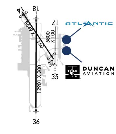
Atlantic Aviation is your premier aviation service provider with more than 100 locations in North America, including Hawaii and the Caribbean. We provide standard ground services you'd expect, with a detailed focus on ensuring an unforgettable customer experience.
Ph: 402-475-8600 Fax: 402-475-1422 Freq: 122.95WebsiteE-Mail
                   
Service
Jet
100LL
SAF
MoGas
Fuel Avail: 24 / 7
Full7.207.57    Last Update: 04/26/2024 13:28:10
PRICES GUARANTEED by FBO.
Self        
Misc. Info: Bulk Fuel DiscountsAddress: 1751 W. KEARNEY AVENUE   LINCOLN, NE 68524

  click here  
Duncan Aviation's FBO is Intl Standard for Business Aircraft Handling (IS-BAH) Stage I accredited. Providing 24-hour, full-service support including quick turns, Type I & Type IV deicing/air-start/prepreheat, APU starts, detail & lav services. Fuel team is NATA Safety 1st Certified. Facility has a unique lobby, pilot's lounge, weather planning/radar, sleeping room, phone room, comp room & Wi-Fi.
Ph: 800-228-4277 Fax: 402-479-1637 Freq: 128.95Website-
                     
Service
Jet
100LL
SAF
MoGas
Fuel Avail: 24 hours
Full6.887.27    Last Update: 04/23/2024 08:43
PRICES GUARANTEED by FBO.
Self        
Misc. Info: Address: 3701 AVIATION ROAD   LINCOLN, NE 68524

ASOSPh: 402-474-9214
-
-
 
If you are an FBO, call 1-203-262-1700 to update your info or email: FltPlan.Advertising@garmin.com
Advertise your FBO on FltPlan.com

Runway & Approach Info for KLNK
Rwy
Length
Land Dist**
Approach*
  Rwy
Length
Land Dist**
Approach*
14
8649x150  8286'          
 
  
32
  8649x150  8179'          
 
17
5801x100  5801'          
 
  
35
  5801x100  5801'          
 
18
12901x200  12901'          
ILS
 111.10 - 177°  
  
36
  12901x200  12901'          
ILS
 109.90 - 357°  
 * only ILS, LOC, LDA, and SDF approaches to a specific runway are shown
** For any Declared Landing Distance Available, please see A/FD or Approach plates
Runway Weight Capability (lbs.) Help
Runway IDSingle WheelDouble WheelDouble Tandem WheelDual Double Wheel
14/3280,000170,000280,000N/A
17/3545,00059,000N/AN/A
18/36100,000200,000400,000N/A
These numbers are Advisory and are not limits.   The Airport Manager should have more accurate Weight Limits
Approach Charts
Approaches    
Current Weather/Notams
Customs Information Send updates to Support@FltPlan.com
Customs Not Available
Database effective 05/16/2024
Airport Diagram of KLNK
Airport Diagram might not be current.

Facility Name: LINCOLN
City Name: LINCOLN
County: LANCASTER
State abbrev: NE
State Name: NEBRASKA
   
Ownership: PUBLICLY OWNED
Use: OPEN TO THE PUBLIC
Owner's Name: LINCOLN ARPT AUTH
Address: BOX 80407
 LINCOLN, NE 68501
Owner's Phone: 402-458-2400
  
Manager's Name: MR. DAVID HARING; EXECUTIVE DIRECTOR.
Address: LINCOLN AIRPORT AUTHORITY, P.O. BOX 80407
 LINCOLN, NE 68501
Phone: 402-458-2400
   
FAA Region: CENTRAL
FAA Field Office: NONE
September 2007 - Photo courtesy of Marion Cain


Click here for full scale & interactive Sectional view of KLNK


Sunrise / Sunset times for LINCOLN

DateSunriseSunset
04/25/24 Thursday6:3220:18
04/26/24 Friday6:3120:19
04/27/24 Saturday6:3020:20
04/28/24 Sunday6:2820:21
04/29/24 Monday6:2720:22
04/30/24 Tuesday6:2620:23
05/01/24 Wednesday6:2420:24
05/02/24 Thursday6:2320:25
05/03/24 Friday6:2220:26
05/04/24 Saturday6:2120:27
05/05/24 Sunday6:1920:28
05/06/24 Monday6:1820:29
05/07/24 Tuesday6:1720:31
05/08/24 Wednesday6:1620:32

Airport Facilities

Airport Attendance ScheduleCONTINUOUS
Airport Status OPERATIONAL (This Status can change at any time - please check NOTAMS)
Airport Lighting ScheduleWHEN ATCT CLSD, MALSR RWYS 18 & 36 OPR CONSLY ON LOW INTST; ODALS RWY 35 OPR CONSLY ON MED INTST; REIL RWY 14 OPR CONSLY ON LOW INTST; REIL RWY 17 OPR CONSLY ON MED INTST; MIRL RWY 14/32 AND RWY 17/35 OPR CONSLY ON LOW INTST; HIRL RWY 18/36 OPR CONSLY ON MED INTST. VASI RWY 32; PAPI RWYS 14, 17,
Airport Storage AvailableTie Downs, Hanger
Extra Services AvailableAir Freight, Air Ambulance, Avionics, Cargo Handling, Charter, Flight Instruction, Aircraft Rental, Aircraft Sales, Annual Surveying
Wind IndicatorYES - (lighted)
Control TowerYES
CTAF Frequency118.500
Unicom Frequency122.950
Rotating Beacon ColorWG
Segmented CircleNO
Landing FeeNO

Airport Inspection Data

Airport InspectedFEDERAL - performed by FAA AIRPORTS FIELD PERSONNEL
Inspection Date07/19/2023

Airport Services

Type of Fuel AvailableGrade 100LL, JET A (freeze point -40C)
Airframe Repair ServiceMAJOR
Power Plant Repair ServiceMAJOR

Geographic Data

LatitudeN4051.1
LongitudeW09645.5 (ESTIMATED)
Arpt Elevation1218ft (SURVEYED)
Magnetic Variation03E
4 miles NWof LINCOLN
Traffic Pattern AltitudeHVY MIL JET TPA 1781 FT AGL
Sectional ChartOMAHA

Aircraft Data

Operations (Reported)YearlyAvg. Daily
General Aviation Transient 2612572
General Aviation Local 2018255
Air Taxi 909925
Commerical 516514
Commuter 00
Military 1432539
Aircraft based on Field
General Aviation Singles 115
General Aviation Multi 14
Jet Aircraft 21
General Aviation Helicopters 2
Military Aircraft 22
Gliders 0
Ultralights 0

FAA Services

FSS on field NO
FSS tie-in COLUMBUS
FSS Phone 1-800-WX-BRIEF
Who issues Notams LNK
Notam D service at airport YES
ARTCC Name MINNEAPOLIS

Federal Status

Airport CertificationAIRPORT RECEIVING SCHEDULED AIR CARRIER SERVICE FROM CARRIERS CERTIFICATED BY THE CIVIL AERONAUTICS BOARD; INDEX C LVL ARFF EQPT PRVDD; FOR ARFF SVC - CTAF.
Aircraft Rescue & Firefighting IndexAIRPORT HAS A CERTIFICATE UNDER CFR PART 139
Airport of EntryNo
Custom Landing RightsNo
Joint Civil/MilitaryNo
Military Landing rightsYES

Federal Agreements

NATIONAL PLAN OF INTEGRATED AIRPORT SYSTEMS (NPIAS)
GRANT AGREEMENTS UNDER FAAP/ADAP/AIP
SURPLUS PROPERTY AGREEMENT UNDER PUBLIC LAW 289
ASSURANCES PURSUANT TO TITLE VI, CIVIL RIGHTS ACT OF 1964

Remarks

BIRDS INVOF ARPT.
ANG: CTC AM OPS 234.65 20 MIN PRIOR TO LDG.
ANG: PROVISIONAL PORT OF ENTRY: US CUSTOMS AVBL ONLY WITH 24 HR NOTICE AND ONLY FOR DOD AIRCREW AND DOD DUTY PAX ON TRAVEL ORDERS. CTC COMD POST. SPACE-A US CUSTOMS ENTRY TO THE US AT THIS ARPT LIMITED TO ACTIVE DUTY MILITARY PERSONNEL ON LEAVE (NO DEPENDENTS).
ARNG: OPR 1300-2100Z++ TUE-FRI, LTD TRAN MAINT.
ARNG: RAMP IS OFFL BUS/PPR TO PRK ARNG RAMP CTC FLT OPS DSN 279-1844, C402-309-1844.
ENSURE CORRECT RWY LINEUP. RWY 17/35 IS THE SHRTR, PARL RWY ON E SIDE OF ARPT.
ANG: AM OPS DSN 279-1293; C402-309-1293.
PPR 24 HRS FOR ACFT PARKING ON THE WEST RAMP - CTC ARPT 402-458-2480.
ANG: CTC AM OPS 234.65 FOR BWC.
FOR CD WHEN ATCT IS CLSD CTC OMAHA APCH AT 402-682-4395.
AF: USAF TMPRY OPS ON WEST RAMP FR APRX SPRING 2021 TO FALL 2022.
PPR TO PARK ON ANG RAMP.
RWY 18 CALM WIND RWY.
RWY 32 APCH HOLDLINE ON SOUTH TWY A.
Airport Communications & Frequencies:
ATIS Frequencies:   Hours(local) of Operation: CONTINUOUS
118.05
290.9
LINCOLN Tower Frequencies:   Hours(local) of operation: 0600 - 2200   
118.5
125.7
253.5
LINCOLN Ground Frequencies:
121.9
275.8
Clearance Delivery Frequencies:
120.7
225.4
CTAF Frequency:
118.500
Unicom Frequency:
122.950
OMAHA Primary Approach Frequencies:  
124.0
270.3
OMAHA Primary Departure Frequencies:  
124.0
270.3
Class C Frequencies:
124.0
270.3
Runway Identifications
Runway Identification: 14/32
Length: 8649 ft
Width: 150 ft
Surface: ASPHALT-FAIR CONDITION
Edge lights: Medium Intensity

Treatment: GROOVED
Weight: PCN 43 /F/B/X/U

 Runway: 14   Runway: 32
Mag heading: 142°Mag heading: 322°
Rwy Slope: -.25% DownRwy Slope: .25% Up
Approach: Approach:
Pattern: Left TrafficPattern: Left Traffic
Markings: NONPRECISION INSTRUMENTMarkings: NONPRECISION INSTRUMENT
Marking Condition: GOODMarking Condition: GOOD
Arresting Dev: Arresting Dev:
Lat & Long: N4052.0  W09646.2Lat. & Long.: N4050.9  W09645.1
Elev: 1198.9 ft. MSLElev: 1177.7 ft. MSL
TCH: 48 ft. AGLTCH: 54 ft. AGL
Visual Glide Path: 3.00 degreesVisual Glide Path: 3.00 degrees
Displaced Threshold: 363 feetDisplaced Threshold: 470 feet
Touchdown Zone: YESTouchdown Zone: YES
Touchdown Elev.: 1199.0 feetTouchdown Elev.: 1192.0 feet
Visual Glide Slope: 4-Light PAPI on LEFT side of RunwayVisual Glide Slope: 4-BOX VASI ON LEFT SIDE OF RUNWAY; VASI UNUSBL BYD 8 DEGS LEFT OF CNTRLN AND 6 DEGS RIGHT OF CNTRLN.
RVR Equipment: RVR Equipment:
RVV Equipment: NORVV Equipment: NO
Approach Lights: Approach Lights:
REIL: YESREIL: NO
Centerline Lights: NOCenterline Lights: NO
Touchdown lights: NOTouchdown lights: NO
Runway Category: Runway with a Non-precision Approach having visibility minimums greater than 3/4 mileRunway Category: Runway with a Non-precision Approach having visibility minimums greater than 3/4 mile
Declared Distances: TORA:8649' TODA:8649' ASDA:8649' LDA:8286'Declared Distances: TORA:8649' TODA:8649' ASDA:8286' LDA:7816'
Obstructions: Obstructions: POLE
Marked: Marked: NOT Marked/Lighted
Clearance slope: 50:1Clearance slope: 38:1; APCH RATIO FM DSPLCD THR 49:1.
Obstruction height: Obstruction height: 59 feet AGL
Dist. from runway: Dist. from runway: 2475 feet
Centerline offset: Centerline offset: 375 feet right of centerline
Comments: Comments:
Runway Identification: 17/35
Length: 5801 ft
Width: 100 ft
Surface: ASPHALT-GOOD CONDITION
Edge lights: Medium Intensity

Treatment: GROOVED
Weight: PCN 15 /R/C/W/T

 Runway: 17   Runway: 35
Mag heading: 177°Mag heading: 357°
Rwy Slope: -.79% DownRwy Slope: .79% Up
Approach: Approach:
Pattern: Left TrafficPattern: Right Traffic
Markings: NONPRECISION INSTRUMENTMarkings: NONPRECISION INSTRUMENT
Marking Condition: GOODMarking Condition: GOOD
Arresting Dev: Arresting Dev:
Lat & Long: N4051.7  W09645.0Lat. & Long.: N4050.7  W09645.1
Elev: 1218.7 ft. MSLElev: 1173.0 ft. MSL
TCH: 44 ft. AGLTCH: 30 ft. AGL
Visual Glide Path: 3.00 degreesVisual Glide Path: 3.00 degrees
Displaced Threshold: NoDisplaced Threshold: No
Touchdown Zone: YESTouchdown Zone: YES
Touchdown Elev.: 1218.7 feetTouchdown Elev.: 1196.1 feet
Visual Glide Slope: 4-Light PAPI on LEFT side of RunwayVisual Glide Slope: 4-Light PAPI on LEFT side of Runway
RVR Equipment: RVR Equipment:
RVV Equipment: NORVV Equipment: NO
Approach Lights: Approach Lights: ODALS - omnidirectional approach lighting system
REIL: YESREIL: NO
Centerline Lights: NOCenterline Lights: NO
Touchdown lights: NOTouchdown lights: NO
Runway Category: Runway with a Non-precision Approach having visibility minimums greater than 3/4 mileRunway Category: Runway with a Visual Approach
Declared Distances: TORA:5800' TODA:5800' ASDA:5400' LDA:5400'Declared Distances: TORA:5800' TODA:5800' ASDA:5800' LDA:5800'
Runway Identification: 18/36
Length: 12901 ft
Width: 200 ft
Surface: CONCRETE ASPHALT-FAIR CONDITION
Edge lights: High Intensity

Treatment: GROOVED
Weight: PCN 58 /R/B/W/U

 Runway: 18   Runway: 36
Mag heading: 177°Mag heading: 357°
Rwy Slope: -.16% DownRwy Slope: .16% Up
Approach: ILSApproach: ILS
Pattern: Right TrafficPattern: Left Traffic
Markings: PRECISION INSTRUMENTMarkings: PRECISION INSTRUMENT
Marking Condition: GOODMarking Condition: GOOD
Arresting Dev: Arresting Dev:
Lat & Long: N4051.8  W09645.7Lat. & Long.: N4049.7  W09645.7
Elev: 1195.2 ft. MSLElev: 1174.7 ft. MSL
TCH: 55 ft. AGLTCH: 56 ft. AGL
Visual Glide Path: 3.00 degreesVisual Glide Path: 3.00 degrees
Displaced Threshold: NoDisplaced Threshold: No
Touchdown Zone: YESTouchdown Zone: YES
Touchdown Elev.: 1195.2 feetTouchdown Elev.: 1174.7 feet
Visual Glide Slope: 4-Light PAPI on LEFT side of RunwayVisual Glide Slope: 4-Light PAPI on LEFT side of Runway
RVR Equipment: TOUCHDOWN-ROLLOUTRVR Equipment: TOUCHDOWN-ROLLOUT
RVV Equipment: NORVV Equipment: NO
Approach Lights: MALSR - 1,400 foot medium intensity approach lighting system with runway alignment indicator lightsApproach Lights: MALSR - 1,400 foot medium intensity approach lighting system with runway alignment indicator lights
REIL: NOREIL: NO
Centerline Lights: NOCenterline Lights: NO
Touchdown lights: NOTouchdown lights: NO
Runway Category: Precision Instrument RunwayRunway Category: Precision Instrument Runway
Declared Distances: TORA:12901' TODA:12901' ASDA:12901' LDA:12901'Declared Distances: TORA:12901' TODA:12901' ASDA:12901' LDA:12901'
C:149/P: