Current Weather/Notams (Metars, TAFs, Notams, NWS Forecast, PIREPS, and nearby weather)
Customs Information Send updates to Support@FltPlan.com
Customs Not Available
Database effective 05/16/2024
Airport Diagram might not be current.
|
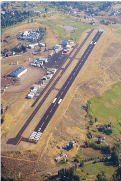
| Facility Name: | HUNT FLD |
| City Name: | LANDER |
| County: | FREMONT |
| State abbrev: | WY |
| State Name: | WYOMING |
| | |
| Ownership: | PUBLICLY OWNED |
| Use: | OPEN TO THE PUBLIC |
| Owner's Name: | CITY OF LANDER |
| Address: | 240 LINCOLN ST |
| | LANDER, WY 82520 |
| Owner's Phone: | 307-332-2870 |
| | |
| Manager's Name: | CHRIS JOHNSON |
| Address: | 240 LINCOLN STREET |
| | LANDER, WY 82520 |
| Phone: | 307-330-3408 |
| | |
| FAA Region: | NORTHWEST MOUNTAIN |
| FAA Field Office: | DEN |
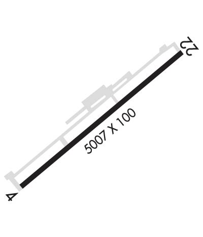
Runway Identifications
Runway Identification: 04/22Length: 5000 ft
Width: 75 ft
Surface: ASPHALT
Edge lights: Medium IntensityTreatment: NONE
Weight: PCN 37 /F/D/X/T
| | Runway: 04 | | Runway: 22 |
| Mag heading: | 40° | Mag heading: | 220° |
| Rwy Slope: | -.64% Down | Rwy Slope: | .64% Up |
| Approach: | | Approach: | |
| Pattern: | Left Traffic | Pattern: | Left Traffic; RIGHT TRAFFIC PATTERNS PERMS ON RWY 22 DEPARTURE DURING HEAVY WIND TO AVOID THE MOUNTAINS DUE TO SEVERE DOWN DRAFTS. |
| Markings: | NONPRECISION INSTRUMENT | Markings: | NONPRECISION INSTRUMENT |
| Marking Condition: | GOOD | Marking Condition: | GOOD |
| Arresting Dev: | | Arresting Dev: | |
| Lat & Long: | N4248.7 W10844.1 | Lat. & Long.: | N4249.2 W10843.3 |
| Elev: | 5588.9 ft. MSL | Elev: | 5556.9 ft. MSL |
| TCH: | 41 ft. AGL | TCH: | 41 ft. AGL |
| Visual Glide Path: | 3.00 degrees | Visual Glide Path: | 3.00 degrees |
| Displaced Threshold: | No | Displaced Threshold: | No |
| Touchdown Zone: | YES | Touchdown Zone: | YES |
| Touchdown Elev.: | 5588.9 feet | Touchdown Elev.: | 5576.7 feet |
| Visual Glide Slope: | 2-Light PAPI on LEFT side of Runway; PAPI RWY 04 UNUSBL BYD 2 NM. | Visual Glide Slope: | 2-Light PAPI on LEFT side of Runway |
| RVR Equipment: | | RVR Equipment: | |
| RVV Equipment: | NO | RVV Equipment: | NO |
| Approach Lights: | | Approach Lights: | |
| REIL: | YES | REIL: | YES |
| Centerline Lights: | NO | Centerline Lights: | NO |
| Touchdown lights: | NO | Touchdown lights: | NO |
| Runway Category: | Runway with a Visual Approach | Runway Category: | Runway with a Non-precision Approach having visibility minimums greater than 3/4 mile |
| Declared Distances: | | Declared Distances: | |
| Obstructions: | TREE | Obstructions: | |
| Marked: | NOT Marked/Lighted | Marked: | |
| Clearance slope: | 24:1 | Clearance slope: | 34:1 |
| Obstruction height: | 135 feet AGL | Obstruction height: | |
| Dist. from runway: | 3538 feet | Dist. from runway: | |
| Centerline offset: | 250 right of centerline | Centerline offset: | |
| Comments: | | Comments: | |