
| ||||||||||||||||||||||||||||||||||||||||||||
| ||||||||||||||||||||||||||||||||||||||||||||
| ||||||||||||||||||||||||||||||||||||||||||||
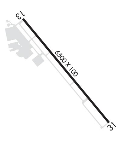
| Rwy | Rwy | |||||||
| 6500x100 | 6500' | 6500x100 | 6500' | |||||
| Runway ID | Single Wheel | Double Wheel | Double Tandem Wheel | Dual Double Wheel |
| 13/31 | 20,000 | 60,000 | N/A | N/A |
| These numbers are Advisory and are not limits. The Airport Manager should have more accurate Weight Limits | ||||
 Airport Diagram might not be current. | |
| Facility Name: | LANCASTER RGNL |
| City Name: | LANCASTER |
| County: | DALLAS |
| State abbrev: | TX |
| State Name: | TEXAS |
| Ownership: | PUBLICLY OWNED |
| Use: | OPEN TO THE PUBLIC |
| Owner's Name: | CITY OF LANCASTER |
| Address: | PO BOX 940 |
| LANCASTER, TX 75146 | |
| Owner's Phone: | 972-218-1300 |
| Manager's Name: | KELLEN BENBROOK |
| Address: | 950 FERRIS ROAD |
| LANCASTER, TX 75146 | |
| Phone: | 972-227-5721; ARPT ADMIN: 972-218-1273. |
| FAA Region: | SOUTHWEST |
| FAA Field Office: | TEX |
| Date | Sunrise | Sunset |
|---|---|---|
| 04/16/24 Tuesday | 6:55 | 19:58 |
| 04/17/24 Wednesday | 6:54 | 19:59 |
| 04/18/24 Thursday | 6:53 | 20:00 |
| 04/19/24 Friday | 6:52 | 20:00 |
| 04/20/24 Saturday | 6:51 | 20:01 |
| 04/21/24 Sunday | 6:50 | 20:02 |
| 04/22/24 Monday | 6:49 | 20:02 |
| 04/23/24 Tuesday | 6:47 | 20:03 |
| 04/24/24 Wednesday | 6:46 | 20:04 |
| 04/25/24 Thursday | 6:45 | 20:05 |
| 04/26/24 Friday | 6:44 | 20:05 |
| 04/27/24 Saturday | 6:43 | 20:06 |
| 04/28/24 Sunday | 6:42 | 20:07 |
| 04/29/24 Monday | 6:41 | 20:07 |
| Airport Attendance Schedule | MON-THUR 0700-1800, FRI-SUN 0700-1900; ARPT UNATNDD THANKSGIVING, CHRISTMAS EVE 1800Z THRU CHRISTMAS. |
| Airport Status | OPERATIONAL (This Status can change at any time - please check NOTAMS) |
| Airport Lighting Schedule | ACTVT MIRL RWY 13/31 - CTAF. |
| Airport Storage Available | Tie Downs |
| Extra Services Available | Avionics, Flight Instruction, Aircraft Rental |
| Wind Indicator | YES - (lighted) |
| Control Tower | NO |
| CTAF Frequency | 122.700 |
| Unicom Frequency | 122.700 |
| Rotating Beacon Color | WG |
| Segmented Circle | YES |
| Landing Fee | NO |
| Airport Inspected | STATE - performed by PRIVATE CONTRACT PERSONNEL |
| Inspection Date | 11/03/2023 |
| Type of Fuel Available | Grade 100LL, JET A |
| Airframe Repair Service | MAJOR |
| Power Plant Repair Service | MAJOR |
| Latitude | N3234.7 |
| Longitude | W09643.1 (ESTIMATED) |
| Arpt Elevation | 501ft (SURVEYED) |
| Magnetic Variation | 06E |
| 2 miles S | of LANCASTER |
| Traffic Pattern Altitude | |
| Sectional Chart | DALLAS-FT WORTH |
| Operations (Reported) | Yearly | Avg. Daily |
|---|---|---|
| General Aviation Transient | 28020 | 77 |
| General Aviation Local | 39030 | 107 |
| Air Taxi | 0 | 0 |
| Commerical | 0 | 0 |
| Commuter | 0 | 0 |
| Military | 50 | 0 |
| Aircraft based on Field | |
|---|---|
| General Aviation Singles | 52 |
| General Aviation Multi | 10 |
| Jet Aircraft | 1 |
| General Aviation Helicopters | 4 |
| Military Aircraft | 0 |
| Gliders | 1 |
| Ultralights | 0 |
| FSS on field | NO |
| FSS tie-in | FORT WORTH |
| FSS Phone | 1-800-WX-BRIEF |
| Who issues Notams | LNC |
| Notam D service at airport | YES |
| ARTCC Name | FORT WORTH |
| Airport Certification | |
| Aircraft Rescue & Firefighting Index | None |
| Airport of Entry | No |
| Custom Landing Rights | No |
| Joint Civil/Military | No |
| Military Landing rights | YES |
| NATIONAL PLAN OF INTEGRATED AIRPORT SYSTEMS (NPIAS) |
| GRANT AGREEMENTS UNDER FAAP/ADAP/AIP |
| ASSURANCES PURSUANT TO TITLE VI, CIVIL RIGHTS ACT OF 1964 |
| FULL ON AUTO-ROTATIONS, SLIDING SKID LDG OR TKOFS BY SKID TYPE HELS ON ANY PAVED SFC NOT AUTH. |
| WILDLIFE ON & INVOF ARPT. |
| GCO AVBL ON FREQ 121.725 (DALLAS/FORT WORTH TRACON ). |
| N RAMP HEL PRKG CIRCLES ROTARY WING USE ONLY, APCH AND DEP NA. |
| FOR CD CTC REGIONAL APCH AT 972-615-2799. |
Airport Communications & Frequencies:
| ||||||||||||||
| Runway: 13 | Runway: 31 | ||
| Mag heading: | 134° | Mag heading: | 314° |
| Rwy Slope: | -.40% Down | Rwy Slope: | .40% Up |
| Approach: | Approach: | ||
| Pattern: | Left Traffic | Pattern: | Right Traffic |
| Markings: | PRECISION INSTRUMENT | Markings: | PRECISION INSTRUMENT |
| Marking Condition: | GOOD | Marking Condition: | GOOD |
| Arresting Dev: | Arresting Dev: | ||
| Lat & Long: | N3235.1 W09643.5 | Lat. & Long.: | N3234.2 W09642.6 |
| Elev: | 501.1 ft. MSL | Elev: | 475.3 ft. MSL |
| TCH: | 45 ft. AGL | TCH: | 50 ft. AGL |
| Visual Glide Path: | 3.00 degrees | Visual Glide Path: | 3.00 degrees |
| Displaced Threshold: | No | Displaced Threshold: | No |
| Touchdown Zone: | YES | Touchdown Zone: | YES |
| Touchdown Elev.: | 501.1 feet | Touchdown Elev.: | 487.0 feet |
| Visual Glide Slope: | 4-Light PAPI on LEFT side of Runway | Visual Glide Slope: | 4-Light PAPI on LEFT side of Runway |
| RVR Equipment: | RVR Equipment: | ||
| RVV Equipment: | NO | RVV Equipment: | NO |
| Approach Lights: | Approach Lights: | ||
| REIL: | NO | REIL: | NO |
| Centerline Lights: | NO | Centerline Lights: | NO |
| Touchdown lights: | NO | Touchdown lights: | NO |
| Runway Category: | Runway with a Visual Approach | Runway Category: | D |
| Declared Distances: | Declared Distances: | ||
| Obstructions: | Obstructions: | TREES | |
| Marked: | Marked: | NOT Marked/Lighted | |
| Clearance slope: | 50:1 | Clearance slope: | 4:1 |
| Obstruction height: | Obstruction height: | 18 feet AGL | |
| Dist. from runway: | Dist. from runway: | 280 feet | |
| Centerline offset: | Centerline offset: | 323 feet left of centerline | |
| Comments: | Comments: |
