Current Weather/Notams (Metars, TAFs, Notams, NWS Forecast, PIREPS, and nearby weather)
Customs Information Send updates to Support@FltPlan.com
Customs Not Available
Database effective 05/16/2024
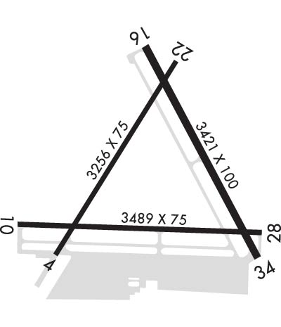
Airport Diagram might not be current. Facility Name: PALM BEACH COUNTY PARK City Name: WEST PALM BEACH County: PALM BEACH State abbrev: FL State Name: FLORIDA Ownership: PUBLICLY OWNED Use: OPEN TO THE PUBLIC Owner's Name: PALM BEACH COUNTY Address: DEPARTMENT OF AIRPORTS, 846 PBIA WEST PALM BEACH, FL 33406-1491 Owner's Phone: 561-471-7420 Manager's Name: LAURA BEEBE Address: 846 PALM BEACH INTL AIRPORT WEST PALM BEACH, FL 33406-1470 Phone: (561) 471-7420 FAA Region: SOUTHERN FAA Field Office: ORL
Runway Identifications Help
Runway Identification: 04/22 Length: 3256 ftWidth: 75 ftSurface: ASPHALT-FAIR CONDITIONEdge lights: Medium Intensity Treatment: NONEWeight: PCN 8 /F/A/Y/T Runway: 04 Runway: 22 Mag heading: 39° Mag heading: 219° Rwy Slope: .04% Up Rwy Slope: -.04% Down Approach: Approach: Pattern: Left Traffic Pattern: Left Traffic Markings: BASIC Markings: BASIC Marking Condition: FAIR Marking Condition: FAIR Arresting Dev: Arresting Dev: Lat & Long: N2635.4 W08005.4 Lat. & Long.: N2635.9 W08005.0 Elev: 12.5 ft. MSL Elev: 13.7 ft. MSL TCH: 41 ft. AGL TCH: 44 ft. AGL Visual Glide Path: 3.00 degrees Visual Glide Path: 3.00 degrees Displaced Threshold: No Displaced Threshold: No Touchdown Zone: YES Touchdown Zone: YES Touchdown Elev.: 14.2 feet Touchdown Elev.: 14.2 feet Visual Glide Slope: 2-Light PAPI on LEFT side of Runway Visual Glide Slope: 2-Light PAPI on LEFT side of Runway RVR Equipment: RVR Equipment: RVV Equipment: NO RVV Equipment: NO Approach Lights: Approach Lights: REIL: NO REIL: NO Centerline Lights: NO Centerline Lights: NO Touchdown lights: NO Touchdown lights: NO Runway Category: Runway with a Visual Approach Runway Category: Runway with a Visual Approach Declared Distances: Declared Distances: Obstructions: TREE Obstructions: BRUSH Marked: NOT Marked/Lighted Marked: NOT Marked/Lighted Clearance slope: 21:1 Clearance slope: 21:1 Obstruction height: 37 feet AGL Obstruction height: 16 feet AGL Dist. from runway: 970 feet Dist. from runway: 525 feet Centerline offset: Centerline offset: 70 feet left of centerline Comments: Comments:
Runway Identification: 10/28 Length: 3489 ftWidth: 75 ftSurface: ASPHALT-GOOD CONDITIONEdge lights: Medium Intensity Treatment: NONEWeight: PCN 10 /F/A/Y/T Runway: 10 Runway: 28 Mag heading: 99° Mag heading: 279° Rwy Slope: .01% Up Rwy Slope: -.01% Down Approach: Approach: Pattern: Left Traffic Pattern: Left Traffic Markings: BASIC Markings: BASIC Marking Condition: FAIR Marking Condition: FAIR Arresting Dev: Arresting Dev: Lat & Long: N2635.5 W08005.5 Lat. & Long.: N2635.5 W08004.8 Elev: 12.4 ft. MSL Elev: 12.7 ft. MSL TCH: 45 ft. AGL TCH: 45 ft. AGL Visual Glide Path: 4.00 degrees Visual Glide Path: 4.00 degrees Displaced Threshold: No Displaced Threshold: No Touchdown Zone: YES Touchdown Zone: YES Touchdown Elev.: 12.6 feet Touchdown Elev.: 13.3 feet Visual Glide Slope: 2-Light PAPI on LEFT side of Runway Visual Glide Slope: 2-Light PAPI on LEFT side of Runway RVR Equipment: RVR Equipment: RVV Equipment: NO RVV Equipment: NO Approach Lights: Approach Lights: REIL: NO REIL: NO Centerline Lights: NO Centerline Lights: NO Touchdown lights: NO Touchdown lights: NO Runway Category: Runway with a Visual Approach Runway Category: Runway with a Visual Approach Declared Distances: Declared Distances: Obstructions: TREES Obstructions: BRUSH Marked: NOT Marked/Lighted Marked: NOT Marked/Lighted Clearance slope: 20:1; RWY 28 APCH SLP 23:1 TO AER. Clearance slope: 15:1 Obstruction height: 42 feet AGL Obstruction height: 11 feet AGL Dist. from runway: 1045 feet Dist. from runway: 370 feet Centerline offset: 125 right of centerline Centerline offset: 50 feet left of centerline Comments: Comments:
Runway Identification: 16/34 Length: 3421 ftWidth: 100 ftSurface: ASPHALT-FAIR CONDITIONEdge lights: Medium Intensity Treatment: NONEWeight: PCN 15 /F/A/X/T Runway: 16 Runway: 34 Mag heading: 159° Mag heading: 339° Rwy Slope: -.02% Down Rwy Slope: .02% Up Approach: Approach: Pattern: Left Traffic Pattern: Left Traffic Markings: NONPRECISION INSTRUMENT Markings: NONPRECISION INSTRUMENT Marking Condition: FAIR Marking Condition: FAIR Arresting Dev: Arresting Dev: Lat & Long: N2635.9 W08005.1 Lat. & Long.: N2635.4 W08004.8 Elev: 13.7 ft. MSL Elev: 13.1 ft. MSL TCH: 43 ft. AGL TCH: 44 ft. AGL Visual Glide Path: 3.50 degrees Visual Glide Path: 3.50 degrees Displaced Threshold: No Displaced Threshold: No Touchdown Zone: YES Touchdown Zone: YES Touchdown Elev.: 14.2 feet Touchdown Elev.: 14.2 feet Visual Glide Slope: 2-Light PAPI on LEFT side of Runway Visual Glide Slope: 2-Light PAPI on LEFT side of Runway RVR Equipment: RVR Equipment: RVV Equipment: NO RVV Equipment: NO Approach Lights: Approach Lights: REIL: NO REIL: NO Centerline Lights: NO Centerline Lights: NO Touchdown lights: NO Touchdown lights: NO Runway Category: Runway with a Visual Approach Runway Category: Runway with a Non-precision Approach Declared Distances: Declared Distances: Obstructions: TREES Obstructions: BRUSH Marked: NOT Marked/Lighted Marked: NOT Marked/Lighted Clearance slope: 23:1; RWY 34 APCH SLP 25:1 TO AER. Clearance slope: 1:1 Obstruction height: 17 feet AGL Obstruction height: 5 feet AGL Dist. from runway: 600 feet Dist. from runway: 200 feet Centerline offset: 30 right of centerline Centerline offset: 150 feet right of centerline Comments: Comments: RWY 34 HAS 5 FT BRUSH 200 FT FM RWY END 150 FT RIGHT.