
| ||||||||||||||||||||||||||||||||||||||||||||
| ||||||||||||||||||||||||||||||||||||||||||||
| ||||||||||||||||||||||||||||||||||||||||||||
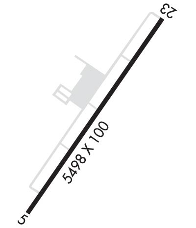
| Rwy | Rwy | |||||||
| 5498x100 | 5498' | 109.35 - 046° | 5498x100 | 5498' | ||||
| Runway ID | Single Wheel | Double Wheel | Double Tandem Wheel | Dual Double Wheel |
| 05/23 | 40,000 | 60,000 | N/A | N/A |
| These numbers are Advisory and are not limits. The Airport Manager should have more accurate Weight Limits | ||||
 Airport Diagram might not be current. | |
| Facility Name: | TRIANGLE NORTH EXEC |
| City Name: | LOUISBURG |
| County: | FRANKLIN |
| State abbrev: | NC |
| State Name: | NORTH CAROLINA |
| Ownership: | PUBLICLY OWNED |
| Use: | OPEN TO THE PUBLIC |
| Owner's Name: | FRANKLIN COUNTY |
| Address: | 113 MARKET STREET |
| LOUISBURG, NC 27549 | |
| Owner's Phone: | 919-554-1863 |
| Manager's Name: | BO CARSON |
| Address: | 440 AIRPORT DRIVE |
| LOUISBURG, NC 27549 | |
| Phone: | 919-496-1234 |
| FAA Region: | SOUTHERN |
| FAA Field Office: | MEM |
| Date | Sunrise | Sunset |
|---|---|---|
| 04/22/24 Monday | 6:30 | 19:54 |
| 04/23/24 Tuesday | 6:29 | 19:54 |
| 04/24/24 Wednesday | 6:28 | 19:55 |
| 04/25/24 Thursday | 6:27 | 19:56 |
| 04/26/24 Friday | 6:26 | 19:57 |
| 04/27/24 Saturday | 6:24 | 19:58 |
| 04/28/24 Sunday | 6:23 | 19:59 |
| 04/29/24 Monday | 6:22 | 20:00 |
| 04/30/24 Tuesday | 6:21 | 20:00 |
| 05/01/24 Wednesday | 6:20 | 20:01 |
| 05/02/24 Thursday | 6:19 | 20:02 |
| 05/03/24 Friday | 6:18 | 20:03 |
| 05/04/24 Saturday | 6:17 | 20:04 |
| 05/05/24 Sunday | 6:16 | 20:05 |
| Airport Attendance Schedule | 7 Days A Week 0800-1800; ARPT UNATNDD THANKSGIVING & CHRISTMAS. |
| Airport Status | OPERATIONAL (This Status can change at any time - please check NOTAMS) |
| Airport Lighting Schedule | ACTVT MALSR RWY 05; REIL RWY 23; HIRL RWY 05/23 - CTAF. PAPI RWY 05 & 23 OPER CONSLY. |
| Airport Storage Available | Tie Downs |
| Extra Services Available | Glider, Flight Instruction, Parachute Jumping, Aircraft Rental, Aircraft Sales, Glider Towing |
| Wind Indicator | YES - (lighted) |
| Control Tower | NO |
| CTAF Frequency | 123.000 |
| Unicom Frequency | 123.000 |
| Rotating Beacon Color | WG |
| Segmented Circle | YES |
| Landing Fee |
| Airport Inspected | STATE - performed by STATE AERONAUTICAL PERSONNEL |
| Inspection Date | 07/01/2023 |
| Type of Fuel Available | Grade 100LL, JET A-1 (icing inhibitor, freeze point -50C) |
| Airframe Repair Service | MAJOR |
| Power Plant Repair Service | MAJOR |
| Latitude | N3601.4 |
| Longitude | W07819.8 (ESTIMATED) |
| Arpt Elevation | 368ft (SURVEYED) |
| Magnetic Variation | 09W |
| 5 miles SW | of LOUISBURG |
| Traffic Pattern Altitude | |
| Sectional Chart | CHARLOTTE |
| Operations (Reported) | Yearly | Avg. Daily |
|---|---|---|
| General Aviation Transient | 18000 | 49 |
| General Aviation Local | 42300 | 116 |
| Air Taxi | 0 | 0 |
| Commerical | 0 | 0 |
| Commuter | 0 | 0 |
| Military | 2500 | 7 |
| Aircraft based on Field | |
|---|---|
| General Aviation Singles | 89 |
| General Aviation Multi | 3 |
| Jet Aircraft | 1 |
| General Aviation Helicopters | 7 |
| Military Aircraft | 0 |
| Gliders | 5 |
| Ultralights | 0 |
| FSS on field | NO |
| FSS tie-in | RALEIGH |
| FSS Phone | 1-800-WX-BRIEF |
| Who issues Notams | LHZ |
| Notam D service at airport | YES |
| ARTCC Name | WASHINGTON |
| Airport Certification | |
| Aircraft Rescue & Firefighting Index | None |
| Airport of Entry | No |
| Custom Landing Rights | No |
| Joint Civil/Military | No |
| Military Landing rights | No |
| NATIONAL PLAN OF INTEGRATED AIRPORT SYSTEMS (NPIAS) |
| GRANT AGREEMENTS UNDER FAAP/ADAP/AIP |
| ASSURANCES PURSUANT TO TITLE VI, CIVIL RIGHTS ACT OF 1964 |
| ARPT PHONE 919-496-1234; MAKE PRIOR ARNGMTS DRG FBO HOURS FOR SVCS AFTER HOURS. |
| BIRDS ON & INVOF ARPT. |
| HEL FLIGHT TNG DAILY PRIMRLY ON W SIDE OF ARPT AND TWY. |
| DAILY SKYDIVING OPS. |
| GLIDER ACT DALGT HRS WKENDS. |
| FOR CD CTC RALEIGH APCH AT 919-380-3144. |
Airport Communications & Frequencies:
| ||||||||||||||
| Runway: 05 | Runway: 23 | ||
| Mag heading: | 46° | Mag heading: | 226° |
| Rwy Slope: | -.71% Down | Rwy Slope: | .71% Up |
| Approach: | ILS/DME | Approach: | |
| Pattern: | Right Traffic | Pattern: | Left Traffic |
| Markings: | PRECISION INSTRUMENT | Markings: | NONPRECISION INSTRUMENT |
| Marking Condition: | GOOD | Marking Condition: | GOOD |
| Arresting Dev: | Arresting Dev: | ||
| Lat & Long: | N3601.0 W07820.2 | Lat. & Long.: | N3601.8 W07819.5 |
| Elev: | 367.9 ft. MSL | Elev: | 328.8 ft. MSL |
| TCH: | 42 ft. AGL | TCH: | 49 ft. AGL |
| Visual Glide Path: | 3.00 degrees | Visual Glide Path: | 3.00 degrees |
| Displaced Threshold: | No | Displaced Threshold: | No |
| Touchdown Zone: | YES | Touchdown Zone: | YES |
| Touchdown Elev.: | 368.0 feet | Touchdown Elev.: | 352.0 feet |
| Visual Glide Slope: | 4-Light PAPI on LEFT side of Runway | Visual Glide Slope: | 4-Light PAPI on LEFT side of Runway |
| RVR Equipment: | RVR Equipment: | ||
| RVV Equipment: | NO | RVV Equipment: | NO |
| Approach Lights: | MALSR - 1,400 foot medium intensity approach lighting system with runway alignment indicator lights | Approach Lights: | |
| REIL: | NO | REIL: | YES |
| Centerline Lights: | NO | Centerline Lights: | NO |
| Touchdown lights: | NO | Touchdown lights: | NO |
| Runway Category: | Precision Instrument Runway | Runway Category: | Runway with a Non-precision Approach having visibility minimums greater than 3/4 mile |
| Declared Distances: | Declared Distances: | ||
| Obstructions: | TREES | Obstructions: | TREES |
| Marked: | NOT Marked/Lighted | Marked: | NOT Marked/Lighted |
| Clearance slope: | 35:1 | Clearance slope: | 32:1 |
| Obstruction height: | 41 feet AGL | Obstruction height: | 41 feet AGL |
| Dist. from runway: | 1640 feet | Dist. from runway: | 1537 feet |
| Centerline offset: | 352 left of centerline | Centerline offset: | 502 feet left of centerline |
| Comments: | Comments: | 2 FT RISING GND 157 FT FM THR BOTH SIDES OF CNTRLN. |
