Current Weather/Notams (Metars, TAFs, Notams, NWS Forecast, PIREPS, and nearby weather)
Customs Information Send updates to Support@FltPlan.com
Customs Not Available
Database effective 05/16/2024
Airport Diagram might not be current.
|
| Facility Name: | WILLIAM T PIPER MEML |
| City Name: | LOCK HAVEN |
| County: | CLINTON |
| State abbrev: | PA |
| State Name: | PENNSYLVANIA |
| | |
| Ownership: | PUBLICLY OWNED |
| Use: | OPEN TO THE PUBLIC |
| Owner's Name: | CITY OF LOCK HAVEN |
| Address: | 20 EAST CHURCH STREET |
| | LOCK HAVEN, PA 17745 |
| Owner's Phone: | 570-893-5610 |
| | |
| Manager's Name: | DOUGLAS WENKER |
| Address: | 353 PROCTOR STREET |
| | LOCK HAVEN, PA 17745 |
| Phone: | 570-748-5123 |
| | |
| FAA Region: | EASTERN |
| FAA Field Office: | HAR |
Runway Identifications
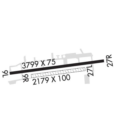
Runway Identification: 09L/27RLength: 3799 ft
Width: 75 ft
Surface: ASPHALT-GOOD CONDITION
Edge lights: Medium IntensityTreatment: NONE
| | Runway: 09L | | Runway: 27R |
| Mag heading: | 93° | Mag heading: | 273° |
| Rwy Slope: | .01% Up | Rwy Slope: | -.01% Down |
| Approach: | | Approach: | |
| Pattern: | Left Traffic | Pattern: | Right Traffic |
| Markings: | NONPRECISION INSTRUMENT | Markings: | NONPRECISION INSTRUMENT |
| Marking Condition: | GOOD | Marking Condition: | GOOD |
| Arresting Dev: | | Arresting Dev: | |
| Lat & Long: | N4108.1 W07725.8 | Lat. & Long.: | N4108.2 W07724.9 |
| Elev: | 554.7 ft. MSL | Elev: | 555.0 ft. MSL |
| TCH: | 49 ft. AGL | TCH: | 48 ft. AGL |
| Visual Glide Path: | 3.50 degrees | Visual Glide Path: | 4.00 degrees |
| Displaced Threshold: | No | Displaced Threshold: | 465 feet |
| Touchdown Zone: | YES | Touchdown Zone: | YES |
| Touchdown Elev.: | 555.5 feet | Touchdown Elev.: | 555.5 feet |
| Visual Glide Slope: | 2-Light PAPI on LEFT side of Runway; UNUSBL BYD 5 DEGS LEFT OF CNTRLN. | Visual Glide Slope: | 2-Light PAPI on LEFT side of Runway; UNUSBL BYD 6 DEGS LEFT & 8 DEGS RIGHT OF CNTRLN. |
| RVR Equipment: | | RVR Equipment: | |
| RVV Equipment: | NO | RVV Equipment: | NO |
| Approach Lights: | | Approach Lights: | |
| REIL: | YES | REIL: | YES |
| Centerline Lights: | NO | Centerline Lights: | NO |
| Touchdown lights: | NO | Touchdown lights: | NO |
| Runway Category: | Runway with a Visual Approach | Runway Category: | Runway with a Visual Approach |
| Declared Distances: | | Declared Distances: | |
| Obstructions: | TREES | Obstructions: | TREES |
| Marked: | NOT Marked/Lighted | Marked: | NOT Marked/Lighted |
| Clearance slope: | 16:1 | Clearance slope: | 5:1 |
| Obstruction height: | 74 feet AGL | Obstruction height: | 69 feet AGL |
| Dist. from runway: | 1440 feet | Dist. from runway: | 611 feet |
| Centerline offset: | 22 right of centerline | Centerline offset: | 96 feet right of centerline |
| Comments: | | Comments: | 14 FT BERM 84 FT OUT ON CNTRLN RWY 27R. |
Runway Identification: 09R/27LLength: 2179 ft
Width: 100 ft
Surface: GRASS-GOOD CONDITION
Edge lights: Treatment: NONE
| | Runway: 09R | | Runway: 27L |
| Mag heading: | 93° | Mag heading: | 273° |
| Rwy Slope: | .02% Up | Rwy Slope: | -.02% Down |
| Approach: | | Approach: | |
| Pattern: | Left Traffic | Pattern: | Right Traffic |
| Markings: | NONSTANDARD | Markings: | NONSTANDARD |
| Marking Condition: | GOOD; WHITE CONES MARK RWY EDGE AND THLD. | Marking Condition: | GOOD; WHITE CONES MARK RWY EDGE AND THLD. |
| Arresting Dev: | | Arresting Dev: | |
| Lat & Long: | N4108.1 W07725.6 | Lat. & Long.: | N4108.2 W07725.1 |
| Elev: | 553.3 ft. MSL | Elev: | 553.8 ft. MSL |
| TCH: | | TCH: | |
| Visual Glide Path: | | Visual Glide Path: | |
| Displaced Threshold: | No | Displaced Threshold: | No |
| Touchdown Zone: | YES | Touchdown Zone: | YES |
| Touchdown Elev.: | 553.8 feet | Touchdown Elev.: | 553.8 feet |
| Visual Glide Slope: | | Visual Glide Slope: | |
| RVR Equipment: | | RVR Equipment: | |
| RVV Equipment: | NO | RVV Equipment: | NO |
| Approach Lights: | | Approach Lights: | |
| REIL: | NO | REIL: | NO |
| Centerline Lights: | NO | Centerline Lights: | NO |
| Touchdown lights: | NO | Touchdown lights: | NO |
| Runway Category: | Runway with a Visual Approach | Runway Category: | Runway with a Visual Approach |
| Declared Distances: | | Declared Distances: | |
| Obstructions: | | Obstructions: | TREES |
| Marked: | | Marked: | NOT Marked/Lighted |
| Clearance slope: | 20:1 | Clearance slope: | 19:1 |
| Obstruction height: | | Obstruction height: | 66 feet AGL |
| Dist. from runway: | | Dist. from runway: | 1258 feet |
| Centerline offset: | | Centerline offset: | 79 feet left of centerline |
| Comments: | | Comments: | |

