
| ||||||||||||||||||||||||||||||||
| ||||||||||||||||||||||||||||||||
| ||||||||||||||||||||||||||||||||
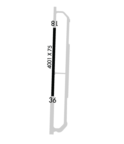
| Rwy | Rwy | |||||||
| 4001x75 | 4001' | 4001x75 | 4001' | |||||
| Runway ID | Single Wheel | Double Wheel | Double Tandem Wheel | Dual Double Wheel |
| 18/36 | 17,000 | N/A | N/A | N/A |
| These numbers are Advisory and are not limits. The Airport Manager should have more accurate Weight Limits | ||||
 Airport Diagram might not be current. | |
| Facility Name: | HEARNE MUNI |
| City Name: | HEARNE |
| County: | ROBERTSON |
| State abbrev: | TX |
| State Name: | TEXAS |
| Ownership: | PUBLICLY OWNED |
| Use: | OPEN TO THE PUBLIC |
| Owner's Name: | CITY OF HEARNE |
| Address: | 209 CEDAR ST. |
| HEARNE, TX 77859 | |
| Owner's Phone: | 979-279-3461 |
| Manager's Name: | ALANZO ECHAVARRIA; CITY/ARPT MGR. |
| Address: | 209 CEDAR ST. |
| HEARNE, TX 77859 | |
| Phone: | 979-279-3461 |
| FAA Region: | SOUTHWEST |
| FAA Field Office: | TEX |
| Date | Sunrise | Sunset |
|---|---|---|
| 04/19/24 Friday | 6:54 | 19:58 |
| 04/20/24 Saturday | 6:52 | 19:58 |
| 04/21/24 Sunday | 6:51 | 19:59 |
| 04/22/24 Monday | 6:50 | 20:00 |
| 04/23/24 Tuesday | 6:49 | 20:00 |
| 04/24/24 Wednesday | 6:48 | 20:01 |
| 04/25/24 Thursday | 6:47 | 20:02 |
| 04/26/24 Friday | 6:46 | 20:02 |
| 04/27/24 Saturday | 6:45 | 20:03 |
| 04/28/24 Sunday | 6:44 | 20:04 |
| 04/29/24 Monday | 6:43 | 20:04 |
| 04/30/24 Tuesday | 6:43 | 20:05 |
| 05/01/24 Wednesday | 6:42 | 20:06 |
| 05/02/24 Thursday | 6:41 | 20:06 |
| Airport Attendance Schedule | UNATTENDED |
| Airport Status | OPERATIONAL (This Status can change at any time - please check NOTAMS) |
| Airport Lighting Schedule | MIRL RWY 18/36 OPR VIA PHOTOCELL DUSK TO DAWN, PRESET LOW INTST; TO INCR INTST ACTVT - 123.3. |
| Airport Storage Available | Tie Downs |
| Extra Services Available | Crop Dusting |
| Wind Indicator | YES - (lighted) |
| Control Tower | NO |
| CTAF Frequency | 122.900 |
| Unicom Frequency | |
| Rotating Beacon Color | WG |
| Segmented Circle | YES |
| Landing Fee | NO |
| Airport Inspected | STATE - performed by PRIVATE CONTRACT PERSONNEL |
| Inspection Date | 04/09/2023 |
| Type of Fuel Available | Grade 100LL |
| Airframe Repair Service | None |
| Power Plant Repair Service | None |
| Latitude | N3052.3 |
| Longitude | W09637.3 (ESTIMATED) |
| Arpt Elevation | 284ft (SURVEYED) |
| Magnetic Variation | 04E |
| 1 miles SW | of HEARNE |
| Traffic Pattern Altitude | |
| Sectional Chart | HOUSTON |
| Operations (Reported) | Yearly | Avg. Daily |
|---|---|---|
| General Aviation Transient | 800 | 2 |
| General Aviation Local | 2400 | 7 |
| Air Taxi | 0 | 0 |
| Commerical | 0 | 0 |
| Commuter | 0 | 0 |
| Military | 0 | 0 |
| Aircraft based on Field | |
|---|---|
| General Aviation Singles | 8; THIS AIRPORT DID NOT REPORT THE N-NUMBERS FOR BASED AIRCRAFT. |
| General Aviation Multi | 0 |
| Jet Aircraft | 0 |
| General Aviation Helicopters | 1 |
| Military Aircraft | 0 |
| Gliders | 0 |
| Ultralights | 1 |
| FSS on field | NO |
| FSS tie-in | MONTGOMERY COUNTY |
| FSS Phone | 1-800-WX-BRIEF |
| Who issues Notams | LHB |
| Notam D service at airport | YES |
| ARTCC Name | HOUSTON |
| Airport Certification | |
| Aircraft Rescue & Firefighting Index | None |
| Airport of Entry | No |
| Custom Landing Rights | No |
| Joint Civil/Military | No |
| Military Landing rights | YES |
| NATIONAL PLAN OF INTEGRATED AIRPORT SYSTEMS (NPIAS) |
| SURPLUS PROPERTY AGREEMENT UNDER PUBLIC LAW 289 |
| FOR CD CTC HOUSTON APCH AT 281-443-5844 TO CNL IFR CALL 281-443-5888. |
Airport Communications & Frequencies:
| ||||||||||||
| Runway: 18 | Runway: 36 | ||
| Mag heading: | 177° | Mag heading: | 358° |
| Rwy Slope: | -.11% Down | Rwy Slope: | .11% Up |
| Approach: | Approach: | ||
| Pattern: | Left Traffic | Pattern: | Left Traffic |
| Markings: | NONPRECISION INSTRUMENT | Markings: | NONPRECISION INSTRUMENT |
| Marking Condition: | GOOD | Marking Condition: | GOOD |
| Arresting Dev: | Arresting Dev: | ||
| Lat & Long: | N3052.7 W09637.3 | Lat. & Long.: | N3052.0 W09637.3 |
| Elev: | 284.7 ft. MSL | Elev: | 280.1 ft. MSL |
| TCH: | TCH: | ||
| Visual Glide Path: | Visual Glide Path: | ||
| Displaced Threshold: | No | Displaced Threshold: | No |
| Touchdown Zone: | YES | Touchdown Zone: | YES |
| Touchdown Elev.: | 284.7 feet | Touchdown Elev.: | 283.5 feet |
| Visual Glide Slope: | Visual Glide Slope: | ||
| RVR Equipment: | RVR Equipment: | ||
| RVV Equipment: | NO | RVV Equipment: | NO |
| Approach Lights: | Approach Lights: | ||
| REIL: | NO | REIL: | NO |
| Centerline Lights: | NO | Centerline Lights: | NO |
| Touchdown lights: | NO | Touchdown lights: | NO |
| Runway Category: | D | Runway Category: | D |
| Declared Distances: | Declared Distances: |
