Current Weather/Notams (Metars, TAFs, Notams, NWS Forecast, PIREPS, and nearby weather)
Customs Information Send updates to Support@FltPlan.com
Customs Not Available
Database effective 04/18/2024
Airport Diagram might not be current.
|
| Facility Name: | LOGAN-CACHE |
| City Name: | LOGAN |
| County: | CACHE |
| State abbrev: | UT |
| State Name: | UTAH |
| | |
| Ownership: | PUBLICLY OWNED |
| Use: | OPEN TO THE PUBLIC |
| Owner's Name: | LOGAN CITY & CACHE CO |
| Address: | 199 N. MAIN |
| | LOGAN, UT 84321 |
| Owner's Phone: | (435) 755-1850 |
| | |
| Manager's Name: | JASON RIRIE |
| Address: | 199 N. MAIN |
| | LOGAN, UT 84321 |
| Phone: | (435) 752-8111 |
| | |
| FAA Region: | NORTHWEST MOUNTAIN |
| FAA Field Office: | DEN |
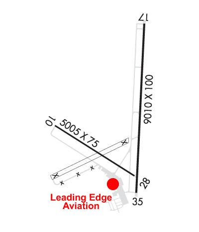
Runway Identifications
Runway Identification: 10/28Length: 4075 ft
Width: 60 ft
Surface: ASPHALT
Edge lights: Treatment: NONE
| | Runway: 10 | | Runway: 28 |
| Mag heading: | 111° | Mag heading: | 291° |
| Rwy Slope: | .24% Up | Rwy Slope: | -.24% Down |
| Approach: | | Approach: | |
| Pattern: | Left Traffic | Pattern: | Left Traffic |
| Markings: | BASIC | Markings: | BASIC |
| Marking Condition: | POOR | Marking Condition: | POOR |
| Arresting Dev: | | Arresting Dev: | |
| Lat & Long: | N4147.5 W11151.9 | Lat. & Long.: | N4147.1 W11151.1 |
| Elev: | 4440.1 ft. MSL | Elev: | 4449.7 ft. MSL |
| TCH: | | TCH: | |
| Visual Glide Path: | | Visual Glide Path: | |
| Displaced Threshold: | No | Displaced Threshold: | No |
| Touchdown Zone: | YES | Touchdown Zone: | YES |
| Touchdown Elev.: | 4447.7 feet | Touchdown Elev.: | 4449.7 feet |
| Visual Glide Slope: | | Visual Glide Slope: | |
| RVR Equipment: | | RVR Equipment: | |
| RVV Equipment: | NO | RVV Equipment: | NO |
| Approach Lights: | | Approach Lights: | |
| REIL: | NO | REIL: | NO |
| Centerline Lights: | NO | Centerline Lights: | NO |
| Touchdown lights: | NO | Touchdown lights: | NO |
| Runway Category: | Runway with a Visual Approach | Runway Category: | Runway with a Visual Approach |
| Declared Distances: | TORA:4075' TODA:4075' | Declared Distances: | TORA:4075' TODA:4075' |
| Obstructions: | | Obstructions: | RR |
| Marked: | | Marked: | NOT Marked/Lighted |
| Clearance slope: | 50:1 | Clearance slope: | 12:1 |
| Obstruction height: | | Obstruction height: | 23 feet AGL |
| Dist. from runway: | | Dist. from runway: | 485 feet |
| Centerline offset: | | Centerline offset: | B |
| Comments: | | Comments: | |
Runway Identification: 17/35Length: 9020 ft
Width: 100 ft
Surface: ASPHALT
Edge lights: High IntensityTreatment: NONE
Weight: PCN 55 /F/D/X/T
| | Runway: 17 | | Runway: 35 |
| Mag heading: | 172° | Mag heading: | 352° |
| Rwy Slope: | .00% Down | Rwy Slope: | .00% Up |
| Approach: | ILS/DME | Approach: | |
| Pattern: | Left Traffic | Pattern: | Left Traffic |
| Markings: | PRECISION INSTRUMENT | Markings: | PRECISION INSTRUMENT |
| Marking Condition: | GOOD | Marking Condition: | GOOD |
| Arresting Dev: | | Arresting Dev: | |
| Lat & Long: | N4148.4 W11150.9 | Lat. & Long.: | N4146.9 W11151.0 |
| Elev: | 4456.8 ft. MSL | Elev: | 4456.4 ft. MSL |
| TCH: | 45 ft. AGL | TCH: | 39 ft. AGL |
| Visual Glide Path: | 3.00 degrees | Visual Glide Path: | 3.00 degrees |
| Displaced Threshold: | No | Displaced Threshold: | No |
| Touchdown Zone: | YES | Touchdown Zone: | YES |
| Touchdown Elev.: | 4456.9 feet | Touchdown Elev.: | 4456.4 feet |
| Visual Glide Slope: | 2-Light PAPI on LEFT side of Runway | Visual Glide Slope: | 2-Light PAPI on LEFT side of Runway |
| RVR Equipment: | | RVR Equipment: | |
| RVV Equipment: | NO | RVV Equipment: | NO |
| Approach Lights: | MALSR - 1,400 foot medium intensity approach lighting system with runway alignment indicator lights | Approach Lights: | |
| REIL: | NO | REIL: | YES |
| Centerline Lights: | NO | Centerline Lights: | NO |
| Touchdown lights: | NO | Touchdown lights: | NO |
| Runway Category: | Precision Instrument Runway | Runway Category: | Runway with a Non-precision Approach having visibility minimums greater than 3/4 mile |
| Declared Distances: | TORA:9020' TODA:9020' ASDA:9020' LDA:9020' | Declared Distances: | TORA:9020' TODA:9020' ASDA:9020' LDA:9020' |
| Obstructions: | RR | Obstructions: | |
| Marked: | NOT Marked/Lighted | Marked: | |
| Clearance slope: | 15:1 | Clearance slope: | 50:1 |
| Obstruction height: | 23 feet AGL | Obstruction height: | |
| Dist. from runway: | 555 feet | Dist. from runway: | |
| Centerline offset: | 560 left of centerline | Centerline offset: | |
| Comments: | | Comments: | |

