Current Weather/Notams (Metars, TAFs, Notams, NWS Forecast, PIREPS, and nearby weather)
Customs Information Send updates to Support@FltPlan.com
Customs Not Available
Database effective 05/16/2024
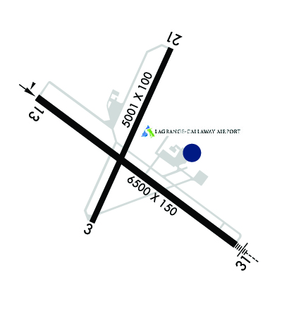
Airport Diagram might not be current. Facility Name: LAGRANGE/CALLAWAY City Name: LAGRANGE County: TROUP State abbrev: GA State Name: GEORGIA Ownership: PUBLICLY OWNED Use: OPEN TO THE PUBLIC Owner's Name: CITY OF LA GRANGE & TROUP CO Address: TROUP COUNTY, 100 RIDLEY AVE, CITY, 200 RIDLEY AVE LAGRANGE, GA 30241 Owner's Phone: 706-883-1610 Manager's Name: TROY ANDERSON Address: 200 AIRPORT PARKWAY LAGRANGE, GA 30240 Phone: 706-616-1553 FAA Region: SOUTHERN FAA Field Office: ATL
Runway Identifications Help
Runway Identification: 03/21 Length: 5000 ftWidth: 100 ftSurface: ASPHALT-FAIR CONDITIONEdge lights: Treatment: NONE Runway: 03 Runway: 21 Mag heading: 28° Mag heading: 208° Rwy Slope: .31% Up Rwy Slope: -.31% Down Approach: Approach: Pattern: Left Traffic Pattern: Left Traffic Markings: NONPRECISION INSTRUMENT Markings: NONPRECISION INSTRUMENT Marking Condition: GOOD Marking Condition: GOOD Arresting Dev: Arresting Dev: Lat & Long: N3300.3 W08504.6 Lat. & Long.: N3301.0 W08504.2 Elev: 677.9 ft. MSL Elev: 693.6 ft. MSL TCH: TCH: Visual Glide Path: Visual Glide Path: Displaced Threshold: No Displaced Threshold: No Touchdown Zone: YES Touchdown Zone: YES Touchdown Elev.: 684.2 feet Touchdown Elev.: 693.6 feet Visual Glide Slope: Visual Glide Slope: RVR Equipment: RVR Equipment: RVV Equipment: NO RVV Equipment: NO Approach Lights: Approach Lights: REIL: NO REIL: NO Centerline Lights: NO Centerline Lights: NO Touchdown lights: NO Touchdown lights: NO Runway Category: Runway with a Non-precision Approach having visibility minimums greater than 3/4 mile Runway Category: Runway with a Visual Approach Declared Distances: Declared Distances: Obstructions: TREES Obstructions: TREES Marked: NOT Marked/Lighted Marked: NOT Marked/Lighted Clearance slope: 14:1 Clearance slope: 11:1 Obstruction height: 81 feet AGL Obstruction height: 72 feet AGL Dist. from runway: 1334 feet Dist. from runway: 992 feet Centerline offset: 246 left of centerline Centerline offset: 230 feet right of centerline Comments: Comments:
Runway Identification: 13/31 Length: 6499 ftWidth: 100 ftSurface: ASPHALT-GOOD CONDITIONEdge lights: High Intensity Treatment: GROOVED Runway: 13 Runway: 31 Mag heading: 131° Mag heading: 310° Rwy Slope: -.19% Down Rwy Slope: .19% Up Approach: Approach: ILS Pattern: Left Traffic Pattern: Left Traffic Markings: PRECISION INSTRUMENT Markings: PRECISION INSTRUMENT Marking Condition: GOOD Marking Condition: GOOD Arresting Dev: Arresting Dev: Lat & Long: N3300.8 W08504.9 Lat. & Long.: N3300.2 W08503.9 Elev: 687.7 ft. MSL Elev: 675.3 ft. MSL TCH: 41 ft. AGL TCH: 40 ft. AGL Visual Glide Path: 3.00 degrees Visual Glide Path: 3.00 degrees Displaced Threshold: No Displaced Threshold: No Touchdown Zone: YES Touchdown Zone: YES Touchdown Elev.: 687.7 feet Touchdown Elev.: 680.6 feet Visual Glide Slope: 4-Light PAPI on LEFT side of Runway Visual Glide Slope: 4-Light PAPI on RIGHT side of Runway RVR Equipment: RVR Equipment: RVV Equipment: NO RVV Equipment: NO Approach Lights: Approach Lights: MALSR - 1,400 foot medium intensity approach lighting system with runway alignment indicator lights REIL: YES REIL: NO Centerline Lights: NO Centerline Lights: NO Touchdown lights: NO Touchdown lights: NO Runway Category: Runway with a Non-precision Approach having visibility minimums greater than 3/4 mile Runway Category: Precision Instrument Runway Declared Distances: Declared Distances: Obstructions: TREES Obstructions: TREES Marked: NOT Marked/Lighted Marked: NOT Marked/Lighted Clearance slope: 18:1 Clearance slope: 38:1 Obstruction height: 123 feet AGL Obstruction height: 143 feet AGL Dist. from runway: 2414 feet Dist. from runway: 5634 feet Centerline offset: 675 right of centerline Centerline offset: 592 feet right of centerline Comments: Comments: