Current Weather/Notams (Metars, TAFs, Notams, NWS Forecast, PIREPS, and nearby weather)
Customs Information Send updates to Support@FltPlan.com
Customs Not Available
Database effective 05/16/2024
Airport Diagram might not be current.
|
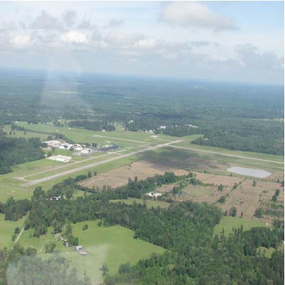
| Facility Name: | ANGELINA COUNTY |
| City Name: | LUFKIN |
| County: | ANGELINA |
| State abbrev: | TX |
| State Name: | TEXAS |
| | |
| Ownership: | PUBLICLY OWNED |
| Use: | OPEN TO THE PUBLIC |
| Owner's Name: | ANGELINA COUNTY |
| Address: | COUNTY COURTHOUSE |
| | LUFKIN, TX 75901 |
| Owner's Phone: | 936-634-5413 |
| | |
| Manager's Name: | GARY LETNEY |
| Address: | 800 AIRPORT BLVD. |
| | DIBOLL, TX 75941 |
| Phone: | 936-634-7511 |
| | |
| FAA Region: | SOUTHWEST |
| FAA Field Office: | TEX |
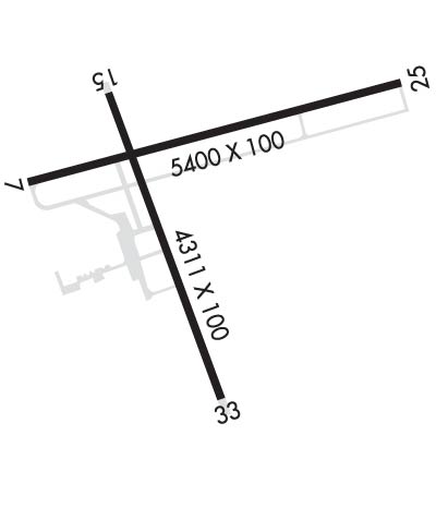
Runway Identifications
Runway Identification: 07/25Length: 5400 ft
Width: 100 ft
Surface: ASPHALT-GOOD CONDITION
Edge lights: Medium IntensityTreatment: NONE
| | Runway: 07 | | Runway: 25 |
| Mag heading: | 73° | Mag heading: | 253° |
| Rwy Slope: | .21% Up | Rwy Slope: | -.21% Down |
| Approach: | ILS | Approach: | |
| Pattern: | Left Traffic | Pattern: | Left Traffic |
| Markings: | PRECISION INSTRUMENT | Markings: | NONPRECISION INSTRUMENT |
| Marking Condition: | GOOD | Marking Condition: | GOOD |
| Arresting Dev: | | Arresting Dev: | |
| Lat & Long: | N3114.1 W09445.4 | Lat. & Long.: | N3114.3 W09444.4 |
| Elev: | 284.1 ft. MSL | Elev: | 295.6 ft. MSL |
| TCH: | | TCH: | 45 ft. AGL |
| Visual Glide Path: | | Visual Glide Path: | 3.00 degrees |
| Displaced Threshold: | No | Displaced Threshold: | No |
| Touchdown Zone: | YES | Touchdown Zone: | YES |
| Touchdown Elev.: | 286.6 feet | Touchdown Elev.: | 295.6 feet |
| Visual Glide Slope: | | Visual Glide Slope: | 4-Light PAPI on LEFT side of Runway |
| RVR Equipment: | | RVR Equipment: | |
| RVV Equipment: | NO | RVV Equipment: | NO |
| Approach Lights: | MALSR - 1,400 foot medium intensity approach lighting system with runway alignment indicator lights | Approach Lights: | |
| REIL: | NO | REIL: | NO |
| Centerline Lights: | NO | Centerline Lights: | NO |
| Touchdown lights: | NO | Touchdown lights: | NO |
| Runway Category: | Precision Instrument Runway | Runway Category: | Runway with a Non-precision Approach having visibility minimums greater than 3/4 mile |
| Declared Distances: | | Declared Distances: | |
| Obstructions: | TREE | Obstructions: | TREES |
| Marked: | NOT Marked/Lighted | Marked: | NOT Marked/Lighted |
| Clearance slope: | 37:1 | Clearance slope: | 21:1 |
| Obstruction height: | 84 feet AGL | Obstruction height: | 67 feet AGL |
| Dist. from runway: | 3315 feet | Dist. from runway: | 1660 feet |
| Centerline offset: | 230 left of centerline | Centerline offset: | 505B |
| Comments: | | Comments: | |
Runway Identification: 16/34Length: 4311 ft
Width: 100 ft
Surface: ASPHALT-GOOD CONDITION
Edge lights: Medium IntensityTreatment: NONE
| | Runway: 16 | | Runway: 34 |
| Mag heading: | 158° | Mag heading: | 338° |
| Rwy Slope: | -.36% Down | Rwy Slope: | .36% Up |
| Approach: | | Approach: | |
| Pattern: | Left Traffic | Pattern: | Left Traffic |
| Markings: | NONPRECISION INSTRUMENT | Markings: | NONPRECISION INSTRUMENT |
| Marking Condition: | GOOD | Marking Condition: | GOOD |
| Arresting Dev: | | Arresting Dev: | |
| Lat & Long: | N3114.2 W09445.2 | Lat. & Long.: | N3113.5 W09444.9 |
| Elev: | 289.2 ft. MSL | Elev: | 273.6 ft. MSL |
| TCH: | 48 ft. AGL | TCH: | 55 ft. AGL |
| Visual Glide Path: | 3.00 degrees | Visual Glide Path: | 3.00 degrees |
| Displaced Threshold: | No | Displaced Threshold: | 107 feet |
| Touchdown Zone: | YES | Touchdown Zone: | YES |
| Touchdown Elev.: | 289.3 feet | Touchdown Elev.: | 286.4 feet |
| Visual Glide Slope: | 4-BOX VASI ON LEFT SIDE OF RUNWAY | Visual Glide Slope: | 4-BOX VASI ON LEFT SIDE OF RUNWAY |
| RVR Equipment: | | RVR Equipment: | |
| RVV Equipment: | NO | RVV Equipment: | NO |
| Approach Lights: | | Approach Lights: | |
| REIL: | NO | REIL: | NO |
| Centerline Lights: | NO | Centerline Lights: | NO |
| Touchdown lights: | NO | Touchdown lights: | NO |
| Runway Category: | Runway with a Non-precision Approach having visibility minimums greater than 3/4 mile | Runway Category: | Runway with a Non-precision Approach having visibility minimums greater than 3/4 mile |
| Declared Distances: | | Declared Distances: | |
| Obstructions: | TREE | Obstructions: | TREES |
| Marked: | NOT Marked/Lighted | Marked: | NOT Marked/Lighted |
| Clearance slope: | 7:1 | Clearance slope: | 19:1; APCH SLOPE 24;1 TO DSPLCD THR. |
| Obstruction height: | 58 feet AGL | Obstruction height: | 38 feet AGL |
| Dist. from runway: | 640 feet | Dist. from runway: | 930 feet |
| Centerline offset: | 203 right of centerline | Centerline offset: | 200 feet right of centerline |
| Comments: | | Comments: | |