Current Weather/Notams (Metars, TAFs, Notams, NWS Forecast, PIREPS, and nearby weather)
Customs Information Send updates to Support@FltPlan.com
Customs Not Available
Database effective 05/16/2024
Airport Diagram might not be current.
|
| Facility Name: | AUBURN/LEWISTON MUNI |
| City Name: | AUBURN/LEWISTON |
| County: | ANDROSCOGGIN |
| State abbrev: | ME |
| State Name: | MAINE |
| | |
| Ownership: | PUBLICLY OWNED |
| Use: | OPEN TO THE PUBLIC |
| Owner's Name: | CITIES OF AUBURN & LEWISTON |
| Address: | 80 AIRPORT DR |
| | AUBURN, ME 04210 |
| Owner's Phone: | 207-786-0631 |
| | |
| Manager's Name: | JONATHAN LABONTE; AUBURN CITY TRANSPORTATION DIR. |
| Address: | 80 AIRPORT DR |
| | AUBURN, ME 04210 |
| Phone: | 207-786-0631 |
| | |
| FAA Region: | NEW ENGLAND |
| FAA Field Office: | NONE |
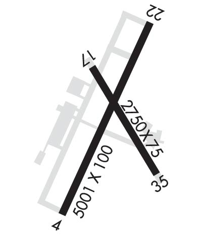
Runway Identifications
Runway Identification: 04/22Length: 5001 ft
Width: 100 ft
Surface: ASPHALT
Edge lights: High IntensityTreatment: GROOVED
| | Runway: 04 | | Runway: 22 |
| Mag heading: | 41° | Mag heading: | 221° |
| Rwy Slope: | -.15% Down | Rwy Slope: | .15% Up |
| Approach: | ILS/DME | Approach: | |
| Pattern: | Left Traffic | Pattern: | Left Traffic |
| Markings: | PRECISION INSTRUMENT | Markings: | NONPRECISION INSTRUMENT |
| Marking Condition: | GOOD | Marking Condition: | GOOD |
| Arresting Dev: | | Arresting Dev: | |
| Lat & Long: | N4402.5 W07017.3 | Lat. & Long.: | N4403.3 W07016.8 |
| Elev: | 270.4 ft. MSL | Elev: | 263.1 ft. MSL |
| TCH: | 49 ft. AGL | TCH: | 35 ft. AGL |
| Visual Glide Path: | 3.00 degrees | Visual Glide Path: | 3.50 degrees |
| Displaced Threshold: | No | Displaced Threshold: | No |
| Touchdown Zone: | YES | Touchdown Zone: | YES |
| Touchdown Elev.: | 270.4 feet | Touchdown Elev.: | 269.7 feet |
| Visual Glide Slope: | 4-Light PAPI on LEFT side of Runway | Visual Glide Slope: | 4-Light PAPI on LEFT side of Runway |
| RVR Equipment: | | RVR Equipment: | |
| RVV Equipment: | NO | RVV Equipment: | NO |
| Approach Lights: | MALSR - 1,400 foot medium intensity approach lighting system with runway alignment indicator lights | Approach Lights: | |
| REIL: | NO | REIL: | YES |
| Centerline Lights: | NO | Centerline Lights: | NO |
| Touchdown lights: | NO | Touchdown lights: | NO |
| Runway Category: | Precision Instrument Runway | Runway Category: | Runway with a Non-precision Approach having visibility minimums greater than 3/4 mile |
| Declared Distances: | | Declared Distances: | |
| Obstructions: | TREES | Obstructions: | TREES |
| Marked: | NOT Marked/Lighted | Marked: | NOT Marked/Lighted |
| Clearance slope: | 42:1 | Clearance slope: | 10:1 |
| Obstruction height: | 100 feet AGL | Obstruction height: | 62 feet AGL |
| Dist. from runway: | 4450 feet | Dist. from runway: | 849 feet |
| Centerline offset: | 450 right of centerline | Centerline offset: | 340 feet right of centerline |
| Comments: | | Comments: | 13 FT POLE 100 FT FM RWY END, 375 FT R, +5 FT ROADWAY 0-200 FT FM RWY END 0-350 FT R. |
Runway Identification: 17/35Length: 2750 ft
Width: 75 ft
Surface: ASPHALT
Edge lights: Medium IntensityTreatment: NONE
| | Runway: 17 | | Runway: 35 |
| Mag heading: | 165° | Mag heading: | 345° |
| Rwy Slope: | 1.16% Up | Rwy Slope: | -1.16% Down |
| Approach: | | Approach: | |
| Pattern: | Left Traffic | Pattern: | Left Traffic |
| Markings: | BASIC | Markings: | BASIC |
| Marking Condition: | GOOD | Marking Condition: | GOOD |
| Arresting Dev: | | Arresting Dev: | |
| Lat & Long: | N4403.1 W07017.1 | Lat. & Long.: | N4402.7 W07016.8 |
| Elev: | 255.5 ft. MSL | Elev: | 287.5 ft. MSL |
| TCH: | | TCH: | |
| Visual Glide Path: | | Visual Glide Path: | |
| Displaced Threshold: | No | Displaced Threshold: | No |
| Touchdown Zone: | YES | Touchdown Zone: | YES |
| Touchdown Elev.: | 287.5 feet | Touchdown Elev.: | 287.5 feet |
| Visual Glide Slope: | | Visual Glide Slope: | |
| RVR Equipment: | | RVR Equipment: | |
| RVV Equipment: | NO | RVV Equipment: | NO |
| Approach Lights: | | Approach Lights: | |
| REIL: | NO | REIL: | NO |
| Centerline Lights: | NO | Centerline Lights: | NO |
| Touchdown lights: | NO | Touchdown lights: | NO |
| Runway Category: | Runway with a Visual Approach | Runway Category: | Runway with a Visual Approach |
| Declared Distances: | | Declared Distances: | |
| Obstructions: | TREE | Obstructions: | TREE |
| Marked: | NOT Marked/Lighted | Marked: | NOT Marked/Lighted |
| Clearance slope: | 17:1 | Clearance slope: | 15:1 |
| Obstruction height: | 73 feet AGL | Obstruction height: | 58 feet AGL |
| Dist. from runway: | 1508 feet | Dist. from runway: | 1077 feet |
| Centerline offset: | 240 left of centerline | Centerline offset: | 199 feet right of centerline |
| Comments: | | Comments: | |

