Current Weather/Notams (Metars, TAFs, Notams, NWS Forecast, PIREPS, and nearby weather)
Customs Information Send updates to Support@FltPlan.com
Phone 352-787-4217Fax 352-787-2176Comments * Hours of Operations 0800-1630 ET Monday-Friday * User Fee Airport *
Database effective 04/18/2024
Airport Diagram might not be current. Facility Name: LEESBURG INTL City Name: LEESBURG County: LAKE State abbrev: FL State Name: FLORIDA Ownership: PUBLICLY OWNED Use: OPEN TO THE PUBLIC Owner's Name: CITY OF LEESBURG Address: PO BOX 490630 LEESBURG, FL 34749-0630 Owner's Phone: 352-516-7236 Manager's Name: TRACEY DEAN Address: PO BOX 490630 LEESBURG, FL 34749 Phone: (352) 728-9801; EXT 1130 OR 352-728-9786. FAA Region: SOUTHERN FAA Field Office: ORL
Runway Identifications Help
Runway Identification: 03W/21W Length: 15000 ftWidth: 2000 ftSurface: WATEREdge lights: Treatment: NONE Runway: 03W Runway: 21W Mag heading: N/A Mag heading: N/A Rwy Slope: .00% Rwy Slope: .00% Approach: Approach: Pattern: Left Traffic Pattern: Left Traffic Markings: Markings: Marking Condition: Marking Condition: Arresting Dev: Arresting Dev: Lat & Long: Lat. & Long.: Elev: 63.0 ft. MSL Elev: 63.0 ft. MSL TCH: TCH: Visual Glide Path: Visual Glide Path: Displaced Threshold: No Displaced Threshold: No Touchdown Zone: NO Touchdown Zone: NO Touchdown Elev.: Touchdown Elev.: Visual Glide Slope: Visual Glide Slope: RVR Equipment: RVR Equipment: RVV Equipment: NO RVV Equipment: NO Approach Lights: Approach Lights: REIL: NO REIL: NO Centerline Lights: NO Centerline Lights: NO Touchdown lights: NO Touchdown lights: NO Runway Category: Runway Category: Declared Distances: Declared Distances:
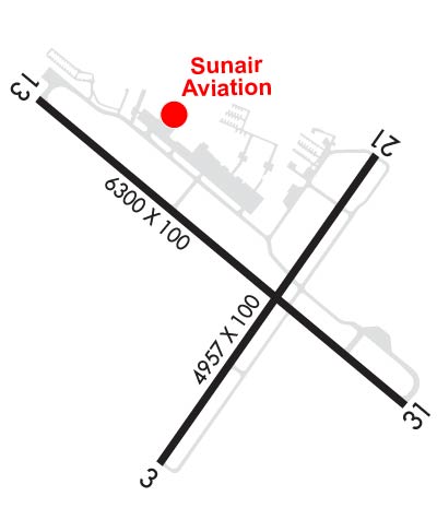
Runway Identification: 04/22 Length: 4957 ftWidth: 100 ftSurface: ASPHALT-GOOD CONDITIONEdge lights: Medium Intensity Treatment: NONEWeight: PCN 14 /F/B/Y/T Runway: 04 Runway: 22 Mag heading: 40° Mag heading: 220° Rwy Slope: .17% Up Rwy Slope: -.17% Down Approach: Approach: Pattern: Left Traffic Pattern: Left Traffic Markings: NONPRECISION INSTRUMENT Markings: BASIC Marking Condition: POOR; MARKINGS FADED. Marking Condition: POOR; MARKINGS FADED. Arresting Dev: Arresting Dev: Lat & Long: N2849.0 W08148.7 Lat. & Long.: N2849.6 W08148.2 Elev: 66.7 ft. MSL Elev: 75.2 ft. MSL TCH: 45 ft. AGL TCH: 45 ft. AGL Visual Glide Path: 3.00 degrees Visual Glide Path: 3.00 degrees Displaced Threshold: No Displaced Threshold: 310 feet Touchdown Zone: YES Touchdown Zone: YES Touchdown Elev.: 70.4 feet Touchdown Elev.: 73.8 feet Visual Glide Slope: 4-Light PAPI on LEFT side of Runway Visual Glide Slope: 4-Light PAPI on RIGHT side of Runway RVR Equipment: RVR Equipment: RVV Equipment: NO RVV Equipment: NO Approach Lights: Approach Lights: REIL: NO REIL: NO Centerline Lights: NO Centerline Lights: NO Touchdown lights: NO Touchdown lights: NO Runway Category: Runway with a Non-precision Approach Runway Category: Runway with a Visual Approach Declared Distances: TORA:4957' TODA:4957' ASDA:4688' LDA:4688' Declared Distances: TORA:4957' TODA:4957' ASDA:4647' LDA:4957' Obstructions: TREES Obstructions: BERM Marked: NOT Marked/Lighted Marked: MARKED and LIGHTED Clearance slope: Clearance slope: 1:1; APCH SLOPE 21:1 TO DSPLCD THR. Obstruction height: 38 feet AGL Obstruction height: 11 feet AGL Dist. from runway: 100 feet Dist. from runway: 81 feet Centerline offset: 235 left of centerline Centerline offset: Comments: 25 FT TREES 235 FT LEFT OF CNTRLN 100 FT FM RWY END. Comments: 11 FT BERM FULL WID OF RWY 81 FT FM RWY END.
Runway Identification: 13/31 Length: 6300 ftWidth: 100 ftSurface: ASPHALTEdge lights: Medium Intensity Treatment: GROOVEDWeight: PCN 17 /F/B/Y/T Runway: 13 Runway: 31 Mag heading: 135° Mag heading: 315° Rwy Slope: -.09% Down Rwy Slope: .09% Up Approach: Approach: Pattern: Left Traffic Pattern: Left Traffic Markings: NONPRECISION INSTRUMENT Markings: NONPRECISION INSTRUMENT Marking Condition: GOOD Marking Condition: GOOD Arresting Dev: Arresting Dev: Lat & Long: N2849.8 W08149.0 Lat. & Long.: N2849.1 W08148.1 Elev: 72.1 ft. MSL Elev: 66.3 ft. MSL TCH: 40 ft. AGL TCH: 40 ft. AGL Visual Glide Path: 3.00 degrees Visual Glide Path: 3.00 degrees Displaced Threshold: 290 feet Displaced Threshold: 400 feet Touchdown Zone: YES Touchdown Zone: YES Touchdown Elev.: 76.0 feet Touchdown Elev.: 73.5 feet Visual Glide Slope: 4-Light PAPI on LEFT side of Runway Visual Glide Slope: 4-Light PAPI on LEFT side of Runway RVR Equipment: RVR Equipment: RVV Equipment: NO RVV Equipment: NO Approach Lights: Approach Lights: REIL: YES REIL: YES Centerline Lights: NO Centerline Lights: NO Touchdown lights: NO Touchdown lights: NO Runway Category: Runway with a Non-precision Approach having visibility minimums greater than 3/4 mile Runway Category: Runway with a Non-precision Approach having visibility minimums greater than 3/4 mile Declared Distances: TORA:6300' TODA:6300' ASDA:5500' LDA:5211' Declared Distances: TORA:6300' TODA:6300' ASDA:6000' LDA:5600' Obstructions: TREES Obstructions: BRUSH Marked: NOT Marked/Lighted Marked: NOT Marked/Lighted Clearance slope: 26:1; APCH SLOPE 34:1 TO DSPLCD THR. Clearance slope: 1:1; APCH SLOPE 22:1 TO DSPLCD THR. Obstruction height: 68 feet AGL Obstruction height: 15 feet AGL Dist. from runway: 1982 feet Dist. from runway: 215 feet Centerline offset: 250 left of centerline Centerline offset: 10 feet left of centerline Comments: Comments: