Current Weather/Notams (Metars, TAFs, Notams, NWS Forecast, PIREPS, and nearby weather)
Customs Information Send updates to Support@FltPlan.com
Customs Not Available
Database effective 05/16/2024
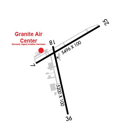
Airport Diagram might not be current. Facility Name: LEBANON MUNI City Name: LEBANON County: GRAFTON State abbrev: NH State Name: NEW HAMPSHIRE Ownership: PUBLICLY OWNED Use: OPEN TO THE PUBLIC Owner's Name: CITY OF LEBANON Address: 51 N PARK ST LEBANON, NH 03766 Owner's Phone: 603-298-8878 Manager's Name: CARL GROSS Address: 5 AIRPARK RD WEST LEBANON, NH 03784 Phone: 603-298-8878 FAA Region: NEW ENGLAND FAA Field Office: NONE
Runway Identifications Help
Runway Identification: 07/25 Length: 5496 ftWidth: 100 ftSurface: ASPHALT-GOOD CONDITIONEdge lights: Medium Intensity Treatment: GROOVED Runway: 07 Runway: 25 Mag heading: 75° Mag heading: 255° Rwy Slope: .21% Up Rwy Slope: -.21% Down Approach: Approach: Pattern: Left Traffic Pattern: Left Traffic Markings: NONPRECISION INSTRUMENT Markings: NONPRECISION INSTRUMENT Marking Condition: GOOD Marking Condition: GOOD Arresting Dev: Arresting Dev: Lat & Long: N4337.6 W07218.7 Lat. & Long.: N4338.0 W07217.7 Elev: 562.5 ft. MSL Elev: 573.8 ft. MSL TCH: 50 ft. AGL TCH: 51 ft. AGL Visual Glide Path: 4.00 degrees Visual Glide Path: 4.00 degrees Displaced Threshold: No Displaced Threshold: No Touchdown Zone: YES Touchdown Zone: YES Touchdown Elev.: 564.1 feet Touchdown Elev.: 573.9 feet Visual Glide Slope: 4-Light PAPI on LEFT side of Runway Visual Glide Slope: 4-Light PAPI on RIGHT side of Runway RVR Equipment: RVR Equipment: RVV Equipment: NO RVV Equipment: NO Approach Lights: Approach Lights: REIL: YES REIL: YES Centerline Lights: NO Centerline Lights: NO Touchdown lights: NO Touchdown lights: NO Runway Category: Runway with a Non-precision Approach having visibility minimums greater than 3/4 mile Runway Category: Runway with a Non-precision Approach having visibility minimums greater than 3/4 mile Declared Distances: Declared Distances: Comments: Comments: 7 FT BRUSH 174 FT FM RWY, 152 FT R.
Runway Identification: 18/36 Length: 5200 ftWidth: 100 ftSurface: ASPHALT-GOOD CONDITIONEdge lights: High Intensity Treatment: GROOVED Runway: 18 Runway: 36 Mag heading: 184° Mag heading: 4° Rwy Slope: .77% Up Rwy Slope: -.77% Down Approach: ILS/DME Approach: Pattern: Left Traffic Pattern: Left Traffic Markings: PRECISION INSTRUMENT Markings: PRECISION INSTRUMENT Marking Condition: GOOD Marking Condition: GOOD Arresting Dev: Arresting Dev: Lat & Long: N4337.8 W07218.4 Lat. & Long.: N4336.9 W07218.2 Elev: 563.5 ft. MSL Elev: 603.3 ft. MSL TCH: TCH: 34 ft. AGL Visual Glide Path: Visual Glide Path: 3.75 degrees Displaced Threshold: No Displaced Threshold: No Touchdown Zone: YES Touchdown Zone: YES Touchdown Elev.: 572.7 feet Touchdown Elev.: 603.3 feet Visual Glide Slope: Visual Glide Slope: 4-Light PAPI on LEFT side of Runway RVR Equipment: RVR Equipment: RVV Equipment: NO RVV Equipment: NO Approach Lights: Approach Lights: REIL: YES REIL: NO Centerline Lights: NO Centerline Lights: NO Touchdown lights: NO Touchdown lights: NO Runway Category: Precision Instrument Runway Runway Category: Runway with a Non-precision Approach having visibility minimums greater than 3/4 mile Declared Distances: Declared Distances: Obstructions: TREES Obstructions: TREES 4000 FT W OF EOR, 970 FT MSL, OBST LGTD. TREES 1500 FT SW OF EOR, 800 FT MSL, OBST LGTD. Marked: NOT Marked/Lighted Marked: NOT Marked/Lighted Clearance slope: 6:1 Clearance slope: 34:1 Obstruction height: 14 feet AGL Obstruction height: Dist. from runway: 287 feet Dist. from runway: Centerline offset: 287 right of centerline Centerline offset: Comments: FENCE 125 FT FM RWY END, 425 FT R. Comments: