Click here for more info on on SMS!

KLCK

RICKENBACKER INTL
COLUMBUS
OH
Time Zone: Eastern
Lat: N 3948.8
Long: W 08255.7
Elev: 744
Var: +07
Longest Runway: 12103
Clr Del: 125.27
Dept. ATIS: 132.75
Arr. ATIS: 132.75
AWOS: 132.75
Ground: 125.27
Tower: 120.05

FBO & Flight Services info for KLCK

FBOs: Update your Fuel Prices

RICKENBACKER AVPh: 614-409-3660 Fax: 614-409-3659 Freq: 122.95
Service
Jet
100LL
SAF
MoGas
Fuel Avail: JET A w/PRIST ADD $0.05/gal.
Full5.716.00    Last Update: 04/24/2024 07:48
PRICES GUARANTEED by FBO.
Self        
 Address: 2295 JOHN CIRCLE DR,   COLUMBUS, OH 43217
AWOSPh: 614-492-2441
-
Freq: 132.75  
If you are an FBO, call 1-203-262-1700 to update your info or email: FltPlan.Advertising@garmin.com
Advertise your FBO on FltPlan.com

Runway & Approach Info for KLCK
Rwy
Length
Land Dist**
Approach*
  Rwy
Length
Land Dist**
Approach*
05L
11902x150  11004'          
ILS/DME
 110.55 - 052°  
  
23R
  11902x150  10913'          
 
05R
12103x200  12103'          
ILS/DME
 110.10 - 052°  
  
23L
  12103x200  12103'          
ILS
 110.10 - 232°  
 * only ILS, LOC, LDA, and SDF approaches to a specific runway are shown
** For any Declared Landing Distance Available, please see A/FD or Approach plates
Runway Weight Capability (lbs.) Help
Runway IDSingle WheelDouble WheelDouble Tandem WheelDual Double Wheel
05L/23R75,000190,000320,000825,000
05R/23L75,000210,000380,000850,000
These numbers are Advisory and are not limits.   The Airport Manager should have more accurate Weight Limits
Approach Charts
Approaches    
Current Weather/Notams
Customs Information Send updates to Support@FltPlan.com
Phone 614-497-1865
Fax 614-497-3559

Comments Mon-Fri 0830-1700 *2 hr advance notice required. Call for hours of service. *Maximum passengers per flight: 15 *Call prior to 1700 on preceding weekday. *Weekend arrivals call prior to 1700 on preceding Friday
Database effective 05/16/2024
Airport Diagram of KLCK
Airport Diagram might not be current.

Facility Name: RICKENBACKER INTL
City Name: COLUMBUS
County: FRANKLIN
State abbrev: OH
State Name: OHIO
   
Ownership: PUBLICLY OWNED
Use: OPEN TO THE PUBLIC
Owner's Name: COLUMBUS RGNL AIRPORT AUTHORITY
Address: 4600 INTERNATIONAL GTWY
 COLUMBUS, OH 43219-1779
Owner's Phone: 614-239-4000
  
Manager's Name: JOSEPH NARDONE
Address: 7250 STAR CHECK DR
 COLUMBUS, OH 43217-1025
Phone: 614-239-4000
   
FAA Region: GREAT LAKES
FAA Field Office: DET


Sunrise / Sunset times for RICKENBACKER INTL

DateSunriseSunset
04/23/24 Tuesday6:4220:19
04/24/24 Wednesday6:4020:20
04/25/24 Thursday6:3920:21
04/26/24 Friday6:3820:22
04/27/24 Saturday6:3620:23
04/28/24 Sunday6:3520:24
04/29/24 Monday6:3420:25
04/30/24 Tuesday6:3220:26
05/01/24 Wednesday6:3120:27
05/02/24 Thursday6:3020:28
05/03/24 Friday6:2920:29
05/04/24 Saturday6:2820:30
05/05/24 Sunday6:2620:31
05/06/24 Monday6:2520:32

Airport Facilities

Airport Attendance ScheduleCONTINUOUS
Airport Status OPERATIONAL (This Status can change at any time - please check NOTAMS)
Airport Lighting Schedule
Airport Storage AvailableTie Downs, Hanger
Extra Services AvailableFlight Instruction, Aircraft Rental
Wind IndicatorYES - (lighted)
Control TowerYES
CTAF Frequency
Unicom Frequency122.950
Rotating Beacon ColorWG
Segmented CircleNO
Landing FeeYES

Airport Inspection Data

Airport InspectedFEDERAL - performed by FAA AIRPORTS FIELD PERSONNEL
Inspection Date07/12/2023

Airport Services

Type of Fuel AvailableGrade 100LL, JET A (freeze point -40C)A++
Airframe Repair ServiceMAJOR
Power Plant Repair ServiceMAJOR

Geographic Data

LatitudeN3948.8
LongitudeW08255.7 (ESTIMATED)
Arpt Elevation743ft (SURVEYED)
Magnetic Variation07W
10 miles Sof COLUMBUS
Traffic Pattern Altitude
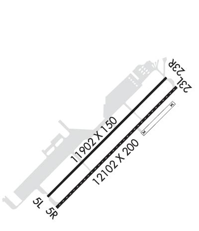
TPA FOR LIGHT ACFT WEIGHING 12500 LBS OR LESS 656'; TPA FOR ACFT GREATER THAN 12500 LBS 1156'; TPA FOR OVERHEAD TFC 1656'.
Sectional ChartCINCINNATI

Aircraft Data

Operations (Reported)YearlyAvg. Daily
General Aviation Transient 836923
General Aviation Local 00
Air Taxi 00
Commerical 1248134
Commuter 00
Military 33189
Aircraft based on Field
General Aviation Singles 4
General Aviation Multi 4
Jet Aircraft 10
General Aviation Helicopters 0
Military Aircraft 32
Gliders 0
Ultralights 0

FAA Services

FSS on field NO
FSS tie-in DAYTON
FSS Phone 1-800-WX-BRIEF
Who issues Notams LCK
Notam D service at airport YES
ARTCC Name INDIANAPOLIS

Federal Status

Airport CertificationAIRPORT RECEIVING SCHEDULED AIR CARRIER SERVICE FROM CARRIERS CERTIFICATED BY THE CIVIL AERONAUTICS BOARD; CLASS I, ARFF INDEX B. INDEX E ARFF EQUIP AVBL UPON REQUEST, CTC ARPT OPNS (614) 374-1869.
Aircraft Rescue & Firefighting IndexAIRPORT HAS A CERTIFICATE UNDER CFR PART 139
Airport of EntryNo
Custom Landing RightsYES; TO REQUEST LANDING RIGHTS CTC US CUSTOMS BTN 0730-2200 MON-FRI AT 614-497-1865.
Joint Civil/MilitaryNo
Military Landing rightsYES

Federal Agreements

NATIONAL PLAN OF INTEGRATED AIRPORT SYSTEMS (NPIAS)
SURPLUS PROPERTY AGREEMENT UNDER PUBLIC LAW 289
ASSURANCES PURSUANT TO TITLE VI, CIVIL RIGHTS ACT OF 1964

Remarks

RSTD: ALL F/W MIL ACFT REQUIRING PARKING AND/OR SERVICE ON 121 ARW RAMP MUST HAVE PPR NR 48 HR PRIOR FR BASE OPS CALL DSN 696-4595 OR C614-492-4595.
RSTD; AMC ACFT OPR RSTD DUR BIRD WATCH CONDITION MODERATE (TKOF AND LDG PERMS ONLY WHEN DEP/ARR RTE AVOID IDENT BIRD ACT, NO LCL IFR/VFR TFC PAT) AND SEVERE(TKOF AND LDG PROH WO OG/CC APVL). CTC COMD POST FOR CURRENT BIRD WATCH COND CODE.
ANG; 121 ARW KC-135 R COMD POST DSN696-4468. LTD TRAN SVC AVBL , WKD 1200-2000++ EXE HOL. LTD TRAN FUEL/PRK, TRAN AIRCREW MUST ASSIST/PERFORM REFUEL OPR. FUEL AVBL ON ANG RAMP ON PRIOR REQ ONLY. ACFT SUPPORT NOT COORD BY PPR 48 HR PRIOR WITH 121 ARW MAY NOT BE AVBL.
ARNG; OPR 1200-2100Z++ WKD EXC HOL. NO TRAN SVC AFTER 1900Z++, DSN346-6411,C614-336-6411.
REMARK; SEE FLIP AP/1 SUPPLEMENTARY ARPT
LGT; BDRY LGT AVBL.
JASU: 6(A/M32A-86) 9(B809) 4(AM32-95).
FLUID: SP PRESAIR LHOX.
OIL; O-128.
TRAN ALERT: LTD SVC AVBL BUT NO PPR RQR. NO ANG TRAN SVC OFF ANG RAMP.
ARNG; CTC C-26 OPS PRIOR TO ENTERING C-26 RAMP/PARKING AREA. DSN346-6473, C6143366473.
BIRDS ON & INVOF ARPT.
CONTACT GND CTL FOR CLNC PRIOR TO PUSHBACK ONTO TWY 'A' FM CARGO RAMP 2.
NOISE ABATEMENT PROC IN EFCT FM 2300-0700; DEP RWY 23L & 23R WINDS 10 KNOTS OR LESS; ARR RWY 05L & 05R WINDS 10 KNOTS OR LESS; ARPT OPS 614-374-1869.
Airport Communications & Frequencies:
ATIS Frequencies:   Hours(local) of Operation: CONTINUOUS
132.75
RICK TOWER Tower Frequencies:   Hours(local) of operation: CONTINUOUS   
120.05
348.4
RICK TOWER Ground Frequencies:
125.275
275.8
Clearance Delivery Frequencies:
125.275
275.8
Emergency Frequencies:
121.5
243.0
Unicom Frequency:
122.950
Remarks
  • CTC GND CON FOR CLNC PRIOR TO PUSHBACK ON CARGO RAMP 2.
  • COLUMBUS Primary Approach Frequencies:  
    134.0
    279.6
    COLUMBUS Primary Departure Frequencies:  
    134.0
    279.6
    Runway Identifications
    Runway Identification: 05L/23R
    Length: 11902 ft
    Width: 150 ft
    Surface: ASPHALT-FAIR CONDITION
    Edge lights: High Intensity

    Treatment: GROOVED
    Weight: PCN 69 /F/B/W/T

     Runway: 05L   Runway: 23R
    Mag heading: 52°Mag heading: 232°
    Rwy Slope: .02% UpRwy Slope: -.02% Down
    Approach: ILS/DMEApproach:
    Pattern: Left TrafficPattern: Left Traffic
    Markings: PRECISION INSTRUMENTMarkings: PRECISION INSTRUMENT
    Marking Condition: GOODMarking Condition: GOOD
    Arresting Dev: Arresting Dev:
    Lat & Long: N3948.2  W08256.6Lat. & Long.: N3949.6  W08254.8
    Elev: 735.5 ft. MSLElev: 737.3 ft. MSL
    TCH: 70 ft. AGLTCH: 79 ft. AGL
    Visual Glide Path: 3.00 degreesVisual Glide Path: 3.00 degrees
    Displaced Threshold: 898 feetDisplaced Threshold: 989 feet
    Touchdown Zone: YESTouchdown Zone: YES
    Touchdown Elev.: 743.9 feetTouchdown Elev.: 742.8 feet
    Visual Glide Slope: 4-Light PAPI on LEFT side of RunwayVisual Glide Slope: 4-Light PAPI on LEFT side of Runway
    RVR Equipment: RVR Equipment:
    RVV Equipment: NORVV Equipment: NO
    Approach Lights: MALSR - 1,400 foot medium intensity approach lighting system with runway alignment indicator lightsApproach Lights:
    REIL: NOREIL: YES
    Centerline Lights: NOCenterline Lights: NO
    Touchdown lights: NOTouchdown lights: NO
    Runway Category: Precision Instrument RunwayRunway Category: D
    Declared Distances: TORA:11902' TODA:11902' ASDA:11902' LDA:11004'Declared Distances: TORA:11902' TODA:11902' ASDA:11902' LDA:10913'
    Runway Identification: 05R/23L
    Length: 12103 ft
    Width: 200 ft
    Surface: CONCRETE ASPHALT
    Edge lights: High Intensity

    Treatment: GROOVED
    Weight: PCN 92 /R/C/W/T

     Runway: 05R   Runway: 23L
    Mag heading: 52°Mag heading: 232°
    Rwy Slope: .04% UpRwy Slope: -.04% Down
    Approach: ILS/DMEApproach: ILS
    Pattern: Left TrafficPattern: Left Traffic
    Markings: PRECISION INSTRUMENTMarkings: PRECISION INSTRUMENT
    Marking Condition: GOODMarking Condition: GOOD
    Arresting Dev: Arresting Dev:
    Lat & Long: N3948.1  W08256.5Lat. & Long.: N3949.5  W08254.7
    Elev: 734.8 ft. MSLElev: 739.5 ft. MSL
    TCH: 69 ft. AGLTCH: 78 ft. AGL
    Visual Glide Path: 3.00 degreesVisual Glide Path: 3.00 degrees
    Displaced Threshold: NoDisplaced Threshold: No
    Touchdown Zone: YESTouchdown Zone: YES
    Touchdown Elev.: 735.8 feetTouchdown Elev.: 739.5 feet
    Visual Glide Slope: 4-Light PAPI on LEFT side of RunwayVisual Glide Slope: 4-Light PAPI on LEFT side of Runway
    RVR Equipment: TOUCHDOWNRVR Equipment: TOUCHDOWN
    RVV Equipment: YESRVV Equipment: YES
    Approach Lights: ALSF2 - standard 2,400 foot high intensity approach lighting system with sequenced flashers, Category II or IIIApproach Lights: MALSR - 1,400 foot medium intensity approach lighting system with runway alignment indicator lights
    REIL: NOREIL: NO
    Centerline Lights: YESCenterline Lights: YES
    Touchdown lights: YESTouchdown lights: NO
    Runway Category: Precision Instrument RunwayRunway Category: Precision Instrument Runway
    Declared Distances: TORA:12103' TODA:12103' ASDA:12103' LDA:12103'Declared Distances: TORA:12103' TODA:12103' ASDA:12103' LDA:12103'
    C:23/P: